Thursday, June 28, 2012

Hope Point Climb--Hope, AK

Pink lupine were a special treat.
We were feeling a bit beaten up by all the tough mountain biking we'd done, and we'd biked all the trails we'd set as our goal for this trip, so for our final day we decided to drive up to Hope (about a 40 min. drive from Cooper Landing) and climb Hope Point. 

This was not going to be a cakewalk:  the trail description said there was an elevation gain of 3,630 feet in 2.2 miles.  That would make this our biggest climb yet--ever!  But after all we'd been through the past 8 days (3-5 hours a day of vigorous exercise) we knew we were in as good of shape as we were going to be in.  Plus, it was just a hike!  How hard could a hike be compared to biking it?!

Up through the meadow.  It was a lot worse coming down!
The trailhead, at the end of the road in Hope, just before the Porcupine Campground on the left, was so new there was still a shovel and broom sitting out for cleanup.  The trail starts off graveled and wide.  After crossing a small bridge the trail splits, with Gull Rock trail veering off to the right and Hope Point heading left along a rushing mountain stream.

So, of course, this trail went UP!  And up and up.  What did we expect?  Well, it was steep.  And in the most beautiful section, we broke out of the trees into a glorious mountain meadow covered in a profusion of wildflowers:  lupine, geraniums, and on and on.  Hope was already far away, way down there, and Turnagain Arm was spreading out to our right.  Through this meadow the trail was gravel on top of hard-packed earth, with a pretty darn close to vertical incline.  It was challenging going, and I found myself taking lots of breaks.  Partly, though, the breaks were because the view was so stunning.  Of all the hikes I have been on in Alaska, this one TOPS my list for beautiful.  I'm afraid I have used too many superlatives in the blog entries describing this vacation, and maybe it was a result of large quantities of endorphins flooding my system from all the exercise, but the beauty just stunned me, and my family concurred.

Our route was up that ridge straight ahead, then left along the snow.  We thought we were going to the peak seen here, but it is the one hidden in the clouds.
Spectacular views of Turnagain Arm
Up, up, and up.  We kept looking up, wondering where the trail would lead us.  Once we got high enough we could see the trail traversing the slopes above us, but then we would lose it in the snow or the clouds.  It was all single track, with loose rocks aplenty.  The technique for getting up these climbs is one step at a time.  Breaks and water are good too.  One thing we did right was bring lots of water:  our hydration packs were filled to the max of 2 and 3 liters respectively, and Douglas and Aurora each had waterbottles as well.  By climb's end we'd have drunk nearly all our water.

Above the meadow the trail leveled out as it followed the top of a ridge.  Below us spread out Turnagain Arm.  We could see Anchorage to our left, the Seward Highway wound around the cliffs of the Turnagain, and far to the right was the head of the arm and the start of the Kenai Peninsula.  Of all the hikes we have taken, this was seemed the most remote, which is ironic because we were in sight of the major population center of the state.  Or perhaps because we were in sight of and yet so far away from all that busy-ness.  It was a perspective that really turned things around.

Heading down--back along the spine of the ridge ahead of us.

At one point we were following a snow chute up, hiking alongside the snow.  When we got to the top, Aurora was waiting for us, eagerly pointing out the mountain goats she'd seen.  We watched them for awhile and then pressed on.  We'd thought we were near the top, but the trail, rather than jogging left across the snowdrift to a peak, continued up to the right across the saddle and into the clouds.

We saw up to 14 mountain goats at one time:  sleeping, playing, fighting, grazing.  It was a treat!

By this time we'd been on the trail over 2 hours, climbing steadily up for probably about 3200-3400 feet.  The signs of fatigue were there:  Douglas was not drinking a lot of water, crabbiness, fuzzy-headedness, lack of decision-making.  The kids were rarin' to go and didn't want to stop, but finally I insisted on a food break.  It was our last day of camping and our snack supply was depleted so we didn't have the hearty lunches we'd had other days:  tuna or ham sandwiches, sausage and cheese.  All we had were crackers, carrot sticks, pudding and granola bars.  I had gotten onto the trail hungry that morning, so I was ravenous by this time.  The kids weren't that hungry and were just begging to push on.  Douglas was getting nervous because the clouds were rolling in quite thickly so visibility was cut way down.  We could no longer see the summit or even any false peaks above us, and below us was all clouds with occasional openings through which we could see the mountain goats wandering the snowfields and meadows below us.  Turnagain Arm was out of sight.

View of Anchorage (not much a view with the clouds)
View towards the head of Turnagain Arm.  Hope is in the bottom right corner of this picture.
We hemmed.  We hawed.  Douglas wanted to turn back.  The kids wanted to keep going.  I wanted to keep going but I was also aware of how tired Douglas and I were, how little the kids had eaten, and how far we had to go back down.  We figured we had to be pretty close to the summit, but we'd thought that a few times before and we discovered we weren't even close.  Finally I decided:  "We're heading down."  The kids were so bummed.  I was bummed too, but it felt like the best choice for the circumstances.

Down we went.  Back past the mountain goats, past the snow chute, down out of the clouds, along the ridge, through the meadow, along the stream to the trailhead.  When Douglas and I walked up to the car, the kids looked like zombies.  They were tired.  On a clear day, with better food we might have pressed on, but for that day, it was what it was.  The view was stupendous, the mountain goats were a treat, the workout was beyond words and the sense of remoteness disquieting.  The kids and I made a pact to come back and complete it--all the way to the top.  It was a stunning and awesome grand finale to our vacation.

Up Snug Harbor Road: Cooper, Russian & Rainbow Lakes


 A couple weeks ago Denver and I had driven up Snug Harbor Road in search of the other end of the Russian Lakes Trail.  We were stymied a mile or two short of our destination as the road still had a foot or more of snow on it so we'd been unable to reach the trailhead.  After biking the Resurrection/Bean Trails we were ready for some mellow activity, so we headed up the Snug Harbor Road to explore.

Ten miles up the road (give or take) was the Rainbow Lake Trailhead.  It looked so beautiful and inviting we just had to stop.  We ate a snack and checked out the trail specs:  1/2 mile, 50 feet elevation gain.  We could handle this!  Out of habit we threw on our hydration packs and away we went.  The Rainbow Lake trails is a sweet, fun little hike.  The trail looks to be handicap accessible and is gravel the whole way.  The views of the surrounding mountains were beautiful.  At Rainbow Lake there was a picnic table and we chatted with the fisherman sitting there, a guy from South Carolina with the thickest accent I've ever heard!  Just down the trail 50 feet was another lake in another picturesque spot.  I have tucked these into my file of "picnic spots" that I want to go back to someday.

Rainbow Lake Trailhead, off Snug Harbor Road

Back to the car we continued up the road. A bit further we reached the Russian Lakes Trail--the other end of it.  We'd driven 2 cars on this vacation in the hope of doing a point-to-point bike ride or two.  Unsure as to whether the snow had melted and the road was accessible, we'd not come back up here to see.  The snow was melted (off the road anyways) and we saw a couple of people jogging down the Russian Lakes Trail.  If we'd done this it would be 20 miles from here down to the Russian River Falls Trailhead, more downhill than up from what I hear.  It is on my bucket list!

Cooper Lake
A mile further along, at the end of the road, was Cooper Lake.  We got out to explore, only to be greeted by some vicious dogs that seemed ready to attack us.  We backtracked hastily and found another spot to check out.  This lake is at a fairly high elevation.  It is dammed up, and I suspect that the beautiful gravel road we'd driven up was built for the purpose of building and servicing the dam and perhaps hydroelectric power as well.  We didn't actually see where the dam was, though our rafting guide had told us where to park for the 6 mile hike from Cooper Landing up to the dam (also on my bucket list).

Bean Creek & Resurrection Pass-Biking Them

This was supposed to be our 'off' or easy workout day.  It ended up being yet another intense one.  Seems like we just can't help ourselves....

In exploring Cooper Landing backroads, we'd discovered a trailhead sign labeled Bean Creek Trail.  It was a rough road, and we drove it till it got too rough to drive (.7 miles up it), and then resolved we would come back and bike it to see where it went.  Meanwhile, we found out that the Bean Creek Trail connects with the Resurrection Pass Trail, which we also wanted to bike.  The Resurrection Pass trailhead is right in Cooper Landing (south end) so we knew it wouldn't be too far.  The question was, how hard was the trail?  It had gotten to the point that everyone laughed at me when I gave my opinion about the difficulty of trails because I kept saying, "It's easy" but it ended up being a killer (Honestly, most trails we biked were pretty darn difficult and not your typical beginner or kid trails.).  So I said, "I think the Bean Trail is pretty easy," and everyone rolled their eyes and laughed.  The reality was it was....uhhhh...a bit rough. 

The road part of the trail ends about a mile past the trailhead sign, which is up Slaughter Ridge Road (which is off Bean Road, the road you take to Kenai Princess Lodge).  That first part was uphillish, but hard packed so pretty easy.  Then it turns into a 4-wheeler type trail.  It was still uphill but not too bad.  Then it turns into a single-track trail that is either massive mud and/or covered with tree roots...AND it is still going uphill.  I cannot believe we made it a mile on a trail like that.  There were spots that had been improved and were smooth, wide and graveled, and I suppose those spots gave us hope. 

Resurrection Falls
Two miles from the trailhead we reached the Resurrection Trail.  Only two miles.  The sign said Resurrection Falls to the left, or Trout Lake/Juneau Lake to the right.  Oh what the heck.  Even Denver was willing to go right and see if we could get to the falls.  Bigish downhill on the way....we are all thinking about biking back up that.  Was this a mistake?  When we got to the falls we realized it was the best decision of the day.  The falls was stupendous.  There was so much water going through it, and we had it all to ourselves, and we could feel the spray even though the falls was falling hundreds of feet into the chasm and we were across from it.  Wow.  I love that falls, but especially with so much water coming through.

We ate lunch and headed back.  At the Bean Trail turn-off we had a pow-wow.  Aurora wanted to keep biking.  Denver and Douglas had had enough.  I didn't like splitting up, but all week I'd stopped short of how far I really wanted to go, and I knew this was our last ride of the vacation.  I said yes, I'd bike 2 more miles with Aurora.  Douglas and Denver headed down the bumpy, muddy Bean Trail, and we headed north towards the Devil's Pass intersection and Hope.

Turnoff to Trout Lake
The trail in that direction was comfortable:  wide enough, gently rolling, not too bumpy and no bear scat.  Pretty soon we'd gone the two miles I'd said I'd go.  We were going at 8-10 mph, making good time and feeling good.  We opted to keep going.  Another mile down the trail we got to the Trout Lake turnoff.  It was 2 more miles to Juneau Lake, which was definitely further than I wanted to go though it was where Aurora had wanted to go.  Trout Lake was a mere half mile off the main trail, so we opted to go there.  Really, it was my curiosity that was spurring me on at that point.  I love to explore and see new places.  A little ways down that trail I saw a black bear print in the mud; ah, time to make some noise. 

Trout Lake Cabin
The Trout Lake cabin is sweet!  It is two stories, with 2 queen beds upstairs (just the wooden platforms, no bedding), a bunkbed downstairs, along with the woodstove, kitchen counter and picnic table.  It is new, with a handicap ramp even.  I most definitely want to come back and stay there sometime.  Aurora waded, we ate the last of our food and drank lots of water and headed back.  The 5.5 miles back to the car was insanely fast and fun.  We were pushing hard, bombing the hills, mud flying, ripping right over the tree roots.  Aurora was in the lead and going fast, but there were still times I had to slow down on the downhills.  The amount of mud on us and our bikes was amazing.  Not an inch of us was not covered, including face and helmets.

Trout Lake
Two die-hard mountain bikers I know say the Resurrection Pass Trail is their favorite for biking.  Now I can see why as it was very do-able.  My uncle had just told me a story of his biking from Hope to Cooper Landing on the Resurrection and a brown bear was on the trail in front of them on the section of trail we were on.  It was too far to turn around and go back to Hope so they just waited for the bear to wander off the trail and then bike on, but my uncle recalls being pretty freaked out.  So I whistled a lot and prayed some that this wouldn't be the day we ran into a bear.

It was a beautiful day to be biking and it felt good and we were each able to get our fill of adventure and exercise. All I can say about the Resurrection Trail is:  I'll be back!

Devil's Pass--Biking It

As we discovered on this trip, biking a trail is very different than hiking it.  Thus, I've included the 'biking it' in the title because I've evaluated the trail specifically on its bikeability.  Devil's Pass was a challenging ride.  The trail starts with a nice little downhill, and then begins to climb.  And climb.  And climb.  And climb.  For the most part it climbs for 5 miles.  The trail itself is in pretty good shape:  it was fairly wide (couple feet) and relatively (note the relatively!) free of roots and rocks, particularly in the first 3 miles before you actually get into the pass.  There weren't a lot of muddy spots.  The drop-offs weren't scary.  There was no bear scat.  It was a really nice trail, besides that it went up and up and up (gradually, though!).

This is at about mile 3 of the Devil's Pass trail.
Denver was tired.  We were only 2 miles in and he was saying, "I'm whipped."  We cajoled.  He kept on.  We met a lady and her dog backpacking from the head of the pass.  We asked her about the upcoming trail.  She'd stayed overnight at the Resurrection/Devil's Pass intersection and said she'd crossed 35 snowfields since that morning, coming down Devil's Pass.  That was not including all the small ones.  She said there was a scary stream crossing coming up.  We got on our bikes and kept going. 

Shortly thereafter Denver was out of gas.  He'd biked pretty much 3.5 miles uphill and his biking muscles just couldn't go any further.  The rest of us were so not ready to turn back.  I proposed a compromise:  Denver and I would stash our bikes and hike; Douglas and Aurora would keep biking.  We'd all meet for lunch somewhere up the trail.  All agreed, so I stashed our bikes, covering them with ferns.  We handed over one hydration pack to Douglas and Aurora and away they went.  The funny thing is that you can be totally tired from biking but get off and walk and your legs feel fresh, so Denver and I were feeling good.

This was a challenging stream crossing with the bikes!
Not long after that we started getting to avalanche chute crossings and snow.  The first crossing was a little dicey.  The snow was melted where the waterfall was coming down, and we had to scootch over the snow so we wouldn't slide down the waterfall, then drop over the edge into the stream and cross it.  Douglas said it was challenging with the bikes.  The trail continued to wind upward gradually.  After two miles, near the first campsite on the trail, Douglas and Aurora stopped and waited for us.  I guess we weren't that far behind despite the fact we were hiking and they were biking.  We ate lunch, watched the mountain sheep or goats (too far away to tell which) on the mountain above us, then headed back.
Snow on the trail, about mile 5.5, just before campsite and lunch break.

Going downhill, Douglas and Aurora made really good time and they had to wait a long time for us.  They got our bikes out and waited (and waited and waited!) for us.  When we got there they took off.  We all agreed to meet at the trailhead, though Denver and I ended up catching up to them and passing Douglas on that final uphill.

Aurora and Douglas, all ready to go after lunch.  They were so ready for the downhill!
That downhill was incredible!  All those miles we'd gone up we now went down.  I didn't pedal for miles.  I held on and braked!  It was insane!  It was a blast!  It was such an adrenaline rush!  And when I was done my arms felt like they were going to drop off!  We were muddy.  We were wiped out.  But that is the trail I would do again in a heartbeat!  How to describe it?  It defies words. 

I appreciated that the trail itself was in good shape, without the bumpity bump of a kazillion rocks and tree roots, so I was able to enjoy the ride more.  Yes, once again I was disappointed that we didn't get further up the pass.  It is 10 miles from the Seward Highway to the Resurrection Pass intersection, and I knew we wouldn't get that far, but I'd hoped we'd get further.  I just remind myself that we can do this again, and hopefully Denver will grow and get stronger.

Aurora's muddy legs!  I love those glowing, white feet.
Summit Lake Lodge is just 10 minutes from Devil's Pass so we headed up there for dinner, after letting Aurora swim in Summit Lake to clean off!

Wednesday, June 27, 2012

Crescent Creek Trail--Biking It


The Crescent Creek Trail, found 3.4 miles off the Sterling Highway in Cooper Landing down Quartz Creek Road (very bumpy!!) is rated an easy trail, so we did this on a Sunday late afternoon.  That morning Aurora had done a 10 mile run on that road, and Douglas and Denver had biked it to get Aurora an accurate mileage reading, so they'd already biked 7 miles.  We decided to just bike from the Quartz Creek Campground, where we were now camping after a weekend in the Sunrise Inn Motel.  Between all that early exercise, combined with the added miles from the campground, this was the family's least-favorite bike of our entire week, though not mine since I was fresh and rarin' to go, having stayed back and done laundry and packed up our stuff in the motel.

The road from the campground to the trailhead is a very gradual uphill--so gradual you wouldn't know it until you turn around and FLY back down.  I was expecting the Crescent Creek Trail to be...easy...like it was rated, but it was NOT easy for mountain biking.  I would say the first mile was all uphill, with hairpin turns, and some roots and rocks to hop on the trail.  Then the trail leveled out into a sweet, comfortably wide (couple feet), flat, smooth trail for awhile, albeit with a dropoff to our right.  I'm getting used to ignoring those dropoffs!

Douglas kept getting way behind us, even on the flat parts, which was weird.  Finally we stopped and waited and discovered he was having serious shifting problems.  I was envisioning our whole biking trip derailed  because of derailleur issues (pun intended!).  Douglas was frustrated but game to keep going, so we got going again, but then started meeting other bikers coming from the other direction.  The trail had narrowed and gotten very rocky by this time, so it was impossible to bike past.  The other bikers got off the trail and we dismounted and walked by them.

Shortly after that Douglas ended up going over his handlebars into the brush in a spectacular fall that we missed, and then Denver started sliding down a shale slope towards the rushing river when the trail threaded its way between an embankment up on one side and shale slope to the river on the other.  Even our "up for anything" Aurora was tired and had no energy and wanted to turn back.  We'd only gone about 3 miles from the trailhead, 6 miles from the campground.  I was disappointed, but like I mentioned earlier in the week, I'd begun to recognize signs of fatigue, and biking on these trails is just too dangerous to be biking very tired (along with the kids' inexperience).  Just after the picture above, taken along Crescent Creek, we turned back.  It would have been 6+ miles to reach Crescent Lake, which was my goal, but no one but me was up for it.

The ride back was stunningly fast.  Although Denver led our biking all week and set the pace, for the downhill we let Aurora and Douglas go ahead because their weight would propel them downhill faster than Denver.  It was challenging going that fast and making split-second judgements about just how fast we could take the hairpin turns.  Denver biffed it on one, taking it a bit too fast, but after that he had better judgement about it.  It is more challenging for the person following because they cannot see the trail ahead and basically have to follow the path the person ahead chooses.  I was impressed with Denver's choices, and although he is a pretty conservative rider, he still went quite fast.  It was fun and I got my share of adrenaline rush, despite disappointment with turning back.

This is the one ride of our entire week I am just itching to go and complete.  I have wanted to do it for years--hike it, bike it, whatever--and I was really hoping this would be the day to do it.  Ah well.  Gives us a great excuse to return!  I can't wait!

Tuesday, June 26, 2012

Rafting the Kenai River

The day after the Slaughter Trail we'd opted to raft the Kenai River, figuring we'd need a break physically.  While we weren't as sore as we'd expected, it was still nice to take a break from our daily 3-5 hours of strenuous exercise.

There are 3 major and a bunch of minor rafting companies in Cooper Landing.  We'd picked up brochures for all of them.  Many specialized in fishing float trips, and we weren't at all interested in those.  I appreciated the brochure for the Alaska Rivers Company because they had their rates published in their brochure, and they had the most different trips to choose from.  Of the ones we were interested in, it would have been a 3 hour float from Cooper Landing to Jim's Landing, all along the Sterling Highway, or the 7 hour "adventure" that included class III rapids, a float through the Kenai River Canyon to Skilak Lake, lunch on the beach of Skilak Lake and then either a boat ride across Skilak Lake or hike up Hidden Creek Trail.  Although 7 hours sounded like a really long day, it sounded more exciting than a 'float' so we opted for that one.

All geared up with rainwear, rubber boots and PFDs.


We didn't need to bring anything with us as they supplied wet gear, rubber boots, life preservers, sunscreen and lunch.  However, we brought some of our own wet gear, extra snacks and water, as well as a camera.  Come 11:00, the 9 of us on this trip walked down to the dock and hopped into the boat one by one. 

The rafts hold up to 12 people.  There were 9 on our trip.

I knew this wasn't going to be a wildly exciting day, but I was curious about the view from the river, as we've driven by the Kenai River so many times on our way to Anchorage.  A view of the Russian River Ferry was one of the things I'd hoped to see, and I got a good view of it.  It takes the ferry about 1-2 minutes to get across the Kenai River, and they charge $11 per person to go across (round trip, I assume), ferrying fishermen to the prime fishing spots on the non-road side of the river.  The ferry used to run 24 hours a day, taking advantage of long daylight hours, but after a person got mauled by a bear along the river in this area last year they now close at 11 p.m., though fishing does continue 24 hours.

The Russian River Ferry shuttles fishermen across the river.

Fisherment lined both sides of the Kenai River

The fishing season just opened June 14th for the first run of salmon, and it was a Saturday, so the river was packed, with shoulder to shoulder fishermen for miles it seemed.  Our trip guide was telling us of a time that he and his buddies had fished in this area and they caught a fish with every single cast.  That is the thrall of fishing the Kenai, though I suspect that people who come here must not mind or actually like the crowds.  Personally, I found a strange fascination with floating by hundreds of fishermen and seeing them casting, again and again, only feet from the next person.  Some people had boats, others had a whole family on shore behind them.   Some were eating, some drinking.  Some people had hip waders, while most had chest waders.  Some looked very experienced, while others were quite inexperienced even by my untrained eye.  There were youth all the way up to the very old, male and female.  There were many nationalities and body sizes.  It was by far the most interesting part of the trip seeing the fishermen close up.

Crowded boat launch

The boat landings were busy too, though we stopped at Jim's Landing for a bathroom break and, according to our guide, sometimes it is difficult to find a spot to land.  With the current ripping along at 4-6 mph, it takes some skill to guide a raft into a small spot on a launching dock.

Heading into Kenai Canyon and slightly rougher waters.

The Class III rapids were not all that exciting.  Water sloshed into the boat a few times, and that was the extent of the excitement.  The closer we got to Skilak Lake the wider and slower the river got.  For us the other interesting and valuable part of the day was our guide, nicknamed Torch.  He was born in Kodiak and grew up in Soldotna and has been guiding on the river for 8 years.  Just the day before he'd climbed one of the peaks in Cooper Landing and snowboarded down it (obviously, one with snow on it!), and then in the evening climbed the Slaughter Trail, for a total of 7000 feet of climbing.  He'd hiked and biked and adventured plenty and knew the trails and had lots of stories to tell, so we were thoroughly entertained.  And as with any time adventuresome Alaskans get together, stories are swapped, exchanging information on the level of daring, skill and conditioning of the storytellers.  While we've only been in Alaska 5 years, we still have our share of stories to tell.

I did ask Torch the most exciting or dangerous situation he'd been in in the 8 years of guiding and he had two to tell.  One time he took the raft down a side stream because there was an eagle on a tree along it.  As they were floating along they suddenly saw a brown bear in the middle of the stream.  The channel was narrow enough that they only way to get past it was to run it over so Torch rowed to shore, had everyone get out (with the bear right there!) and he pulled the raft upstream back to the main channel and got everyone back in.  Another time he was going along when a float plane came up the river at him for a take-off.  The only problem was there were powerlines above his raft, and there was no way the plane would be able to get above the wires in time.  He started to row to shore but there wasn't enough time.  The plane took off, squeaking by under the lines and almost within touching distance of the raft.


When we got to Skilak Lake, another raft (this one with a motor and dog!) met us.  They tied the two boats together and headed for the beach for lunch.  Until now it had been a sunny day and we'd been comfortable in our rain gear.  Now the wind picked up and sun disappeared.  We went from comfy to freezing in a matter of minutes.  We had some extra clothes we'd brought along, so we put it all on--jackets, hats, gloves--and added more raingear on top of our own raingear.

Lunch was simple:  deli ham or turkey on your regular, store-bought bread, carrot sticks and hot cocoa.  After we ate we were given the choice:  we could ride the motorized raft 5 miles across Skilak Lake to the Upper Skilak Lake boat launch, or we could hike the Hidden Creek Trail up to Skilak Lake Road and get picked up there.  We've hiked that trail before and can do so any time, so we opted for the boat ride.  I was glad we did.  We had a different guide to get to know, swap Alaska adventure stories with and quiz about trails.  Come to find out he'd been at the Sea to Ski triathalon in Homer this spring along with our guide Torch and another guide, and they thought they remembered Aurora.  We also got to place the many hikes up peaks around the lake that we've been on, from the lake perspective, giving us a better feel for the lay of the land.


Our guide said he has seen Skilak Lake go from glassy calm to 10 foot swells in 15 minutes.  This lake is the deadliest lake in Alaska, with more people having died on it than any other.  It is a combination of being glacially fed (very cold; low survival time) and surrounded by mountains, as well as winds coming off the glaciers.  Sometimes people don't get a choice about whether they hike or ride if the lake is too choppy.  A few summers ago there were 12 days that the lake was too rough to boat after a trip.  In that case they stash the rafts and get them later once the lake calms down.  That summer, though, there were so many consecutive days of bad weather that all of their rafts were stashed and they had no rafts left to give trips on.  Bad weather or not, they had to get some of them out of there, which was a hairy enterprise, but obviously our guide was still there to tell us about it!

At the boat launch at the Upper Skilak Lake Campground boat launch our guide got both rafts out of the water and the other two women who'd chosen to ride the boat (from New Jersey and Holland) and our family clambered into the van for the 30-45 minute ride back to Cooper Landing.  Shortly after we turned onto Skilak Lake Road from the campground road we saw a black bear a little ways off the road.  We stopped and watched it before it wandered out of sight.  Just minutes later we saw a young black bear, probably a 2-year-old, scarfing down dandelions on the side of the road.  We watched it for a few moments before it dashed out of sight.  And then just minutes later we saw a third black bear along the road.  This one was large and we got a great view of it (no pictures!  I'm sorry!).  Seeing 3 black bear ended up being one of the highlights of our trip.

Overall we all agreed that we enjoyed the day, that it wasn't too slow paced (it helped that we were tired out from yesterday's hike), and that it was worth it--once.  We would recommend it to others, but it would not be worth doing again ourselves at $150 each (half price for kids 12 and under).  The lunch was disappointing and was a bit late (after 3:00!), but the weather and guides made up for it.  And it is one of those things that you just have to experience.  I say you don't truly know Cooper Landing until you've been out on the Kenai River--whether it be rafting or fishing.  We got to cross that one off our bucket list!

Slaughter Trail--Cooper Landing

The view of Kenai Lake from part-way up Slaughter Trail in Cooper Landing
Over the years a couple of people have glowingly mentioned the Slaughter Trail in Cooper Landing.  When in town camping with Denver a few weeks ago I'd driven every road in town in search of the trailhead, but with no luck.  Finally I found a map of Cooper Landing in the Visitor's Center that showed the Slaughter Trail starting somewhere about halfway up Bean Road, with the trail forking, turning into two trails.  We'd scoured every road and trail off both Bean Road and Slaughter Ridge Road with no luck.  It was now time to turn to the locals.  I scored on my first try.  A clerk at Wildman's replied to my inquiry, "Well, I know how I access the Slaughter Trail."  My heart leaped!  The trailhead (unmarked, of course) started just up a little road behind Wildman's, something I would have discovered if I'd just Googled it and clicked on the right source (Even the online sources conflict about the trailhead location.  I suspect originally the trailhead was supposed to be somewhere different.).

I reported back to the family and we planned our day:  after 2 days of mountain biking we were ready to rest those muscles and work our climbing muscles.  Friday of our vacation was chosen.  We lucked out with more good weather.  We parked in the little turnaround up the gravel road past Wildman's.  The trail started out innocently enough, with a single-file, pine-covered path.  It quickly gave way to rocky sections, then some gravel.  The trail is about a 2700 foot climb, as we discovered the next day when we consulted a topographical map.  It starts at about 500 feet and rises to 3200 or so.  

You can get a sense for the steep middle section of this trail.

The steep middle section was the most physically challenging part of the hike.  Footing was relatively good (for hikes like this, where loose gravel is the hiker's bane), but it sure felt and looked like an almost vertical climb in places.  After about 1500 feet we reached a knoll.  The trail was still covered with snow in the shade (though that was the only place on the trail we encountered snow), and there was a glade a evergreen trees, twisted and growing out of rocks, a perfect place for a break, but we weren't in the mood for breaks.  From there the trail turned left, parallel with the Kenai River, and followed the ridge up over another 1000 feet.  False peak after false peak appeared, and we were never quite sure if we were actually "there."  The kids were up ahead of us leading the way and every so often they would wait up for us.  I tried to ignore the steep dropoff on my left, plummeting down.  It wasn't a cliff, but rather a very steep alpine meadow.  A slip would have meant a very long tumble, and while I'm not normally uneasy with heights, I was very aware of what a misstep could lead to.

Steep drop-offs along the upper part of the trail were a bit disconcerting.

We made it up to the top in a little over 2 hours, which was good time for us.  We didn't take any long breaks, just 1-2 minute standing breaks.  Generally when we hike up a peak a frosty wind greets us at the top, so we had a backpack full of extra layers.  Today, however, we didn't need them.  A light wind buffeted us at the top of the ridge, and, unusually, it was a warm wind.  We were comfortable, so we sat down and enjoyed our lunch, breaking for 15-20 minutes--not typical for us!  The view was amazing.  We've climbed the Skyline trail just a few ridges to the south, but this view was so much more beautiful with Kenai Lake and more extensive mountains all around us.  

Going down the kids went on ahead again, stopping at points to wait up for us.  We'd warned them, "No running!" because of the steepness of the trail (sometimes it's because of bear, but we'd seen no scat the entire hike so we weren't particularly concerned about bear), though we know they both love to run down mountains.  Aurora actually asked us what the definition of running was, worried that she might have been running inadvertently!  Going down can be as excruciating as going up--more muscularly than on the heart.  We made it down in an hour and ten minutes, which is just about right (we usually come down in half the time it takes us to get up).  I'm putting this hike down as one of my favorites, above the crowds of Skyline any day.

Someone on my Facebook page asked me why it is called Slaughter Ridge.  I asked around town and one story I got was this:  a group of men from Cooper Landing had a contest with a group of men from Seward.  Each group would kill as many animals as they could in a few days and the group that killed the most would win.  Supposedly the group from Cooper Landing slaughtered 50 Dall sheep in a few days on this ridge as part of that contest.  The other story I got also involved the slaughter of large numbers of Dall sheep, so even if the details are not accurate, that is probably the kernel of truth to this sad story.

Sunday, June 24, 2012

Carter Lake Trail

Every time we've driven to Seward I've seen the Carter Lake Trailhead sign and said, "I want to hike that trail."  It was only a few hundred yards up the road from the Johnson Pass Trailhead, so after we were done biking I talked to family into hiking.  We already had our hydration packs full of water and snacks and a pack full of extra clothes, so it was a simple matter of ditching the helmets and adding bug spray and hats.

The trailhead sign said it was 3.3 miles to Carter Lake, steeply uphill the first 1 1/2 miles, and mountain bikes not recommended.  It started off as a wide, smooth trail so we kept saying, "Why don't they recommend mountain bikes?  This would be a blast to bike down!"  The higher we got the rougher the trail.  It narrowed, got rocky, the trail was a streambed in places, there were tricky stream crossings that required agility and great leaps, and as we got higher there was the mud and then snow a couple feet deep).

 In the picture with snow we are probably at about 1 1/2 miles, just where it was leveling out.  Douglas and I had just worn tennis shoes (dumb!) so our feet were soaked and we were not prepared to hike through snow.  Up there, just 1000 feet higher than the road, the pushki was just coming out of the ground, whereas down at the bottom the pushki was at least 2 feet high already.  It struck me, as it often does, how you can walk from one climate to another, and we did so many times throughout the week.

This trail can actually be a point to point hike from Carter Lake, along Crescent Lake and then descending to the Crescent Creek Trailhead over in Cooper Landing, though it is a rough trail and "not recommended for children, horse or bike" due to the rough trail and tall grasses.  Of course I want to try it someday!


Like the Johnson Pass bike ride we'd just done, I was disappointed to turn back without reaching our goal (Carter Lake), but we simply were not prepared for it.  And while we'd only biked 7.5 miles, we were still tired from that.  So at the top of the rise pictured here we stopped, had a snack, let Aurora run ahead a little ways to see what she could see, and then headed down.  Gee, down is so much easier!  The kids actually exclaimed on the way (Note:  ours are not 'exclaiming' type kids!) that "This is fun!" about the trail.  It kind of reminded me of an obstacle course, as we were crossing logs over streams, leaping the streams, picking our way around bogs or snow or whatever.  It kept it interesting, and obviously the kids were enjoying themselves.  Partly it was an easy enough hike that they could actually breathe, which I can't say about the other hikes we did during this vacation!


I don't usually take pictures of the trailhead signs, but on a whim decided to for this trail. If you like it, comment and let me know and I will do so more often.


Johnson Pass-Biking It

Last summer we'd backpacked the 23 mile Johnson Pass in 2 days from the south end.  We knew what the trail was like but memory is selective, and my memory edited out the rocky, hilly section along the lake in the first 2 miles.  And biking a trail is nothing like backpacking it, as we discovered shortly after starting out on the Johnson Pass Trail-south end-the second day of our trip.

We got pretty good at our routine for maneuvering around downed trees.

Everything was either up or down (sometimes steeply), muddy, or extremely rocky.  Denver was the youngest so we put him in the front to set the pace.  The problem was he was also inexperienced with mountain biking etiquette and technique, and he had the least muscle mass so he could not power up hills that the rest of us could get up.  So it was a frustrating day for us as we had to keep slowing down or walking our bikes when Denver went slowly or couldn't get up hills, and then brake on the downhills as he was the lightest and therefore the slowest on the downhills as well.  The first 2 miles was just up, down, mud or rock.  When we started getting to the downed trees we were already tired.

The first tree, ok.  The second, oh well.  Sometimes we had to drag our bikes under the tree.  Other times we handed them over.  Sometimes we had to dismount and walk under them.  Other times we could dismount and walk them over the tree.  In the third mile there were like 8 downed trees.  The trail was by this time improving, but we were fed up.  Each tree we would say, "Just one more," and the one more would be only 50 yards further.  So after 3.75 miles, we'd had it.  We were whipped.  Even our very game-for-anything Aurora had had enough.  We stopped for lunch, gazed longingly at the upcoming smooth, wide trail, but turned around and headed back, knowing that we had a rough ride back.

The trail here looks so beautiful and inviting...but so many downed trees!

It was our shortest day, and while the trees actually provided us with breaks, they were mentally tiring and we couldn't get into a groove.  When the trees have been cleared it will be a more enjoyable ride, though I think next time perhaps we'll start from the north as there is a longer "nice" section (4 miles or so I think) before getting to the rocky section on that end. 

We chalked this up to more experience and conditioning, and decided to go for a hike since the bike ride was so short!  Next blog post!

Russian River Falls and Lakes Trail-Biking It

So we decided to do the Russian River Falls and Lake trail for our first foray into mountain biking in Alaska, probably because we've hiked it (partly anyways) before and were familiar with it, plus it was close to the Cooper Creek Campground.  So we geared up:  hydration packs with snacks and water, a backpack full of extra clothes, bug dope, and bike repair stuff, waterbottles on the holders on the bikes, helmets, biking gloves, biking shorts (just for Douglas and I).....we hoped we had it all.  Even in our mountain biking days back in college we'd never done "big" trips like this--off road, in the wilderness, with few people around, for many hours.  So it was a leap into the unknown for us--and we didn't know how the kids would do as we'd never done stuff like this when we were 12 and 14 years old....

It rained the entire previous night and that morning right up to the time we left the campground, so we were curious how muddy the trail would be.  The 2-something mile trail from the Russian River Campground trailhead to the falls is graveled with gentle hills (albeit one long one!) so it was a fun, comfortable ride.


The Russian River Falls are awesome, but even cooler is seeing the salmon jumping up the falls!  We  saw one jump 10 feet.  It is amazing what those fish can do!


After leaving the falls we biked back up the trail 1/2 mile to the turnoff to the Russian Lakes trail.  We crossed the bridge and continued on the easy, gravel trail.  We took the turn-off to Barber Cabin along the Lower Russian Lake, intending to stop and get a snack there and rest.  In the picture above an avalanche had come down to the lake and we were able to squeeze by between the snow and the lake along that trail.  The cabin is the same as when we stayed there 3 March's ago.  No one was in it yet though the sign said it was occupied.  We had a quick bite and turned around to head back about a mile to the turnoff to the Upper Russian Lake trail (all clearly marked).


As soon as we turned onto the Upper Russian Lakes trail things got interesting.  First we came across the avalanche we'd met at the bottom by the lake, except here there was a drop-off into the stream and a steep snow slope to cross.  We put Aurora on the far side, me standing in the stream (balanced on rocks for dry feet!), and Denver shoved the bikes across the snow to me as Douglas handed the bikes to him.  I would carry the bike partway across the stream where Aurora would meet me and carry them the rest of the way.

In addition, the trail became narrow with large rocks poking out instead of the smooth gravel.  So what was a relaxing ride in the woods with mild exercise became strenuous quickly.  It was a great deal of uphill, though gradual.  The alpine meadows full of wildflowers were amazing!  My only regret is that we were going so fast and had to keep our eyes on the trail so I couldn't look around much.  Every time I tried, I'd practically bike off the trail, which was a dangerous thing to do because the downhill side of the trail was steep downhills!  Many times when I would get nervous at the dropoffs I would mentally remind myself to just stay focused on the trail.  I really had to trust that the kids could handle it, and they proved that they could, because it was challenging.


At some point we were all feeling pretty tired.  We'd gone 11 miles according to the odometer on Aurora's bike, and if we turned around we would have another 4.5 miles back to the trailhead.  We stopped and talked it over and agreed to go 30 minutes more OR a good spot to stop for lunch OR a view of the Upper Russian Lake (this was our real goal and hope).  Just 10 minutes after that we came across this bridge over a river that had a campsite near it.  It seemed like the perfect place to stop.

We made the kids eat a sandwich each.  It was difficult to eat because we were physically exerting ourselves and we didn't "feel" hungry, but I knew from experience that I was becoming mentally fuzzy, and on mountain bikes in mountains that is a dangerous state to be in.  As the week wore on I became more and more sensitive to not only my own symptoms of fatigue but those of others as well.  Certain signs would clue me off:  not being able to make it up small hills that normally we could, not drinking enough, making stupid judgement mistakes about maneuvering on the trail.  We kept reminding the kids to drink, drink, drink more water.  On this first day I knew food and water were issues because 10 minutes after we were back on our bikes heading to the trailhead my mind was clear and alert again.

It must have been more uphill than we realized because the ride back was fast and relatively easy, despite being tired.  All told we did 15.5 miles that day, and that final 1/2 mile was an amazing, fast adrenaline-pumping joy of a ride.  I was really proud of the kids for achieving that, and actually, I was proud of myself because I think that was the longest off-road biking ride I've ever done in my life too!  We'd seen lots of fairly fresh bear scat but no bears (something I was nervous about considering how fast we were going, and the fact Denver was in the lead and we weren't making a lot of noise).  It was a good start to our week!  And it was a sweet way to celebrate the day we arrived in Alaska 5 years ago!

Saturday, June 23, 2012

An Inside Look at Cooper Landing

Our original plan for the summer included a road trip to the Lower 48 northwest, but rising gas prices made us think twice.  When we started looking at how long it takes to get to, say, Montana, and our timeframe of 3 weeks, we decided we didn't want to be in the car that much.  Denver recently started working on his Cycling Merit Badge for Boy Scouts so we'd recently gotten back into biking.  From the camping trip Denver and I took a few weeks earlier, I had the bright idea of basing out of Cooper Landing and biking many of the great trails that are within 10-15 minutes of town.  After running the idea by the family, we decided we would camp, bike, hike and raft in the Cooper Landing area, and part of the deal was trying every restaurant in town (there are 3).  This blog post will be an overview of some of the amenities and features of Cooper Landing:  restaurants, lodging, convenience stores and other miscellaneous places.

Lodging:
There are 6 public (National Forest Service and state) campgrounds in Cooper Landing:  Russian River Ferry, Russian River, Cooper Creek North and South, Quartz Creek and Crescent Creek.  The Russian River Campground was full with a waiting list when we came into town on Tuesday afternoon in mid-June, which worried me.  We pressed on to the next campground along the Sterling Highway from the south, Cooper Creek South.  Of 25 or so sites, only a handful were available for 3 days, and none were available starting on Friday since they are on a reservation basis, so we chose a site that we could stay at for 3 nights.

Come Friday we headed over to Quartz Creek Campground, but they were already full on Friday morning.  Crescent Creek still had sites available, but that was 3 miles down a very bumpy, rutted road and we had no desire to drive up and down that multiple times a day.  We opted to check out the 
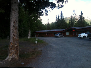
Sunrise Inn Motel on the Sterling Highway at the Quartz Creek turnoff.  It was $130/night for 3 beds, 4 people, which is pretty much the going rate for the other motel and many of the local cabins for rent.  We were very pleased with this motel:  it was the nicest motel I've ever stayed in in my life (motels tend to be old and run-down or cheap).  It was nicely decorated, smelled nice, was spacious and had a great shower (important after camping!).

After a weekend of luxury watching TV and charging all our various electronic devices, we headed over to the Quartz Creek Campground just down the road from the motel.  It had plenty of spots open on Sunday morning, though we would find that nearly every spot would be taken by evening.  I would say 95% of all sites were occupied by RV's, campers and fifth wheels.  If there was a tent, it was a supplement to the camper.  This campground was like a village in the country, with lots of people, lots of traffic, lots of noise, which contrasted with Cooper Creek South where there was some traffic and it was very quiet, partly because it was smaller but the sites were very private there.  The kids liked Quartz Creek more because it was large enough to go biking and exploring in.

Restaurants:
We checked out Sunrise Inn Cafe first.  It is part of the Sunrise Inn Motel on the corner of Quartz Creek Road and the Sterling Highway.  It had good food (not raving good, but solidly good), comfortable service, reasonable prices and a homestyle restaurant atmosphere sporting an amazing collection of salt and pepper shakers.  We went there for both a dinner and breakfast and we would gladly go there again.

I'm going to mention Summit Lake Lodge's restaurants (pizzaria/ice cream/espresso and a sit-down) here even though they are about 15 minutes from Cooper Landing towards Anchorage on the Seward Highway.  We went there 3 times in a week.  The pizza there would rate #1 for us if it was in Homer--we were totally impressed with it.  The sit-down restaurant had a very nice, open atmosphere, felt new, and had $10-11 burgers.  We all got burgers for lunch the day we were there and we were all pleased with them.  Service was great, strawberry lemonade was divine, and even the fries were tasty.  

Sackett's was our next night and the pizza was such a disappointment after Summit Lake Lodge's.  My pulled pork sandwich was good.  The seating was a little odd (three different rooms, some tables, some picnic table).  The building looks like it is 3 different restaurants so I think each "room" represents a different restaurant.  I wouldn't put this one on my go-back-to list.

The Kingfisher Roadhouse was the brunt of our jokes all week.  We put it off because it looks like a dump from the outside/road side.  However, we finally went online and all the reviews said the food was excellent or very good, so Douglas and I went there for Father's Day dinner.  The food is indeed very good, but it is the atmosphere that enchanted me.  It was typical Alaskan with room after room added on helter skelter, but it was so artfully and tastefully decorated that it was fascinating.  The porch had a clear corrugated plastic ceiling which let in a lot of light, and of course it sounds awful but it "fit".  The burgers were $16, and were the cheapest entrees on the menu, so prices were a bit higher than your normal fare.  I would happily go there again, though sans kids.

Convenience Stores:
It cracks me up that I would even write about the convenience stores, but there were only 5 so we could actually check them all out and in spending 10 days in town we knew which one to get what (particularly desserts!!).

Wildman's appears to be the most popular store in town.  It has nice restrooms, showers, a laundromat, ice cream, hot soups and food, espresso, a liquor store and the usual convenience store sundries and snacks.  It has a porch where people were always hanging out, and the inside felt clean and spacious.

Hamilton's was crowded, didn't have a great selection of items and the sales clerk wasn't very friendly, so even though they had a laundromat and gas as well, we wouldn't want to go back there unless we had to.

Almost across the street from Hamilton's was Cooper Landing Grocery (not sure about the name!) and it was our second favorite, with ice cream, pizza (we didn't try but heard it takes a long time), more groceries than any other store in town (not saying much) and souvenirs. 

Gwinn's used to have a resturant but turned that section into a store so it seemed a little barren.  It was dark and didn't have much.  

Right next door to Gwinn's was another store...not sure the name...and it was heavy on the fishing supplies.  Doug said they had a really good selection of snacks there!

Church and Cemetery:

The Catholic church, St. John Neumann, has some very nice grounds for a small church.  They have a shrine for handicapped people, outdoor stations of the cross that is handicapped accessible, the church, a rectory/social hall, another tiny building that might be storage or an office, graves scattered about and a hiking path up a 200-300 foot ridge to a cross overlook.  We found this a very peaceful, inviting place and returned a number of times during our vacation, including for church on Sunday.  Ironically, mass was presided by a priest from Seward, a local deacon and a archdiocesan seminary student!  

A 5-10 minute climb brings you to this peaceful overlook.


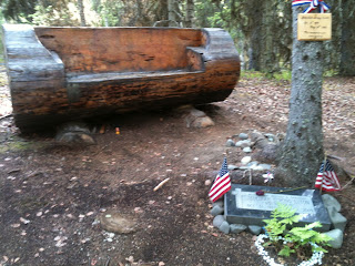
This was one of the graves in the Cooper Landing Cemetery.
In searching for the Slaughter Trail, which we'd heard about and saw on one map of Cooper Landing, we stopped at the Cooper Landing Cemetery, thinking the trail from the parking lot might be the trail we were looking for.  It was not, but the steep trail did lead to the most unusual cemetery I've ever seen.  The graves were dug in the woods here and there.  Footpaths wound randomly throughout the area, leading from one site to the next.  All were very natural, with the landscape hardly disturbed in this heavily treed area.  It felt like...a park.  As we were exploring it, gunshots started going off at close range.  It was disconcerting until we remembered that the local rifle range was right next door!  What kind of sense of humor must a community have to put the cemetery right next door to the shooting range??!!

I'll be honest:  Cooper Landing has never once raised a blip on my radar of "places to go" before.  However, I am smitten.  Although most people come for the fishing, we found 6 easy to challenging mountain biking trails within minutes of Cooper Landing, plus mountains to climb and trails to hike.  I would say we thoroughly explored this little town that boasts 235 or so year-round residents.  Next time we come to visit we will make sure we have reservations to the campground of choice, particularly if it is a weekend.  Besides that, it was 10 days of one of the best vacations I have been on:  enjoying the amazing outdoors of Alaska!

Note:  I will blog about each of the trails we went on separately to avoid one overwhelmingly long blog post!

Friday, June 22, 2012

Exploring Turnagain Arm Area

The last week of May Aurora had a 5-day basketball camp in Anchorage.  Douglas was still working so Denver and I planned on camping in Girdwood, hiking and biking, and then pick up Aurora after the camp was over.  It didn't turn out as planned, as weather and snow interfered!  Nevertheless, we had a great time exploring, so I thought I'd share some of our discoveries.


 About 10 minutes south of Anchorage, you come around a curve and see a pipe sticking out of the cliff with water gushing out.  This is good water, and very cold, so we usually stop and fill up any empty waterbottles we might have in the car.  It is a popular stop, and many locals fill up with water there as well.  I have seen people with a bunch of jugs or 5 gallon containers (done that myself!).  So if you're inclined to try this water and brave running across the highway, check it out!


 I figured that there had to be other campgrounds in Girdwood besides the parking lot at Crow Creek Mine, but I was wrong!  With the Bird Creek Campground still closed (the one we were going to camp at--though we could have pitched  our tent in the overflow area that is still open, but which is basically a parking lot), off we went to Crow Creek Mine.  The last week of May the road was still frozen with a kazillion potholes, so the 2-3 miles back to the mine were torturous.  But the plan was to bike the bike path from Girdwood to Indian, and this was to be the only base for that.  

This is not a 'campground' in any sense of the word.  It is a parking lot that they charge $10 a night for (up from $5/night just 2 years ago) you to park or set up your tent, with a bank of 4 portapotties available to use.  There is no water or electricity, firepits or even picnic tables.  I would go there again...if I had to.  At 5 bucks a night it seemed reasonable, but 10?  Just to park my car and pitch a tent between a bunch of campers?  Argh.  I think the next time I'll drive the extra 10-15 miles to the Portage Glacier turnoff and camp at Williwaw or Black Bear.


 One of the hikes we really wanted to do was to the top of Crow Pass, a nice day hike of probably 4 miles, all uphill 2 miles up to the pass and then 2 miles back down.  However, we'd enquired about it at the Girdwood Ranger Station and they said there was still snow on the road to the trailhead, but we were welcome to try it.  The Crow Pass Trailhead is just pass Crow Creek Mine on the Crow Creek Road, so after we set up our tent we drove up there to see for ourselves.  Sure enough, there was still at least a foot or two of snow on the road to the trailhead, and it was soft snow--not fun for hiking on--since it was raining.  So that nixed one of our plans.


It was raining when we got to Girdwood and it continued to rain all night.  When we got up the next morning we had to come up with yet another alternative plan since we didn't want to bike in the rain and wind.  We decided to go to Whittier, about 15-20 miles away.  We hadn't been there since 5 years ago in August when we'd had a glorious hike--one of the most beautiful I've been on in Alaska.  That memory spurred us on.  We drove to the staging area to drive through the 2-mile tunnel, waited 5 minutes and drove through, observing the rough-hewn stone interior of this car/train tunnel and trying to avoid driving right on the railroad tracks.


Upon exiting the other side we realized immediately that we would NOT be doing any hiking.  There were 3 trails I'd wanted to explore:  the Portage Glacier Trail that goes up over the mountain we'd just come through, and then a couple on the other side of town.  The snow was deep--like, over our car deep.  Remember, this is May 30th.  So we drove through town and gazed longingly at the trailheads.  It was still raining and the snow was soft and mushy and of course we hadn't brought our snowshoes (duh!  How could we have forgotten them??!!) so we drove through the whole town (takes like 10 minutes), gaped at the old bombed-out looking abandoned building that once was the largest building in Alaska, housing troops stationed in Whittier, and at our lunch in the car at a cute little park by a stream.  We drove back to the staging area and waited half an hour for the next time through (once an hour each way) as we'd just missed the last one.  But it was rainy and miserable out and we had nothing much better to do.

Let me backtrack.  Before we came to Whittier we stopped on the mainland side of the tunnel at the Portage Glacier Interpretive Center.  While there we saw a graphic relief model of the entire Chugach Mountains, which extends from north of Anchorage on the Kenai Peninsula.  What amazed me is that although the mountain passes were not labeled, I recognized and have been on many of the passes on various hikes (Resurrection, Crow, Johnson), and could name the passes that I haven't been on.  Two things especially hit me:  how mountainous this section of Alaska is and how every single pass has either a road through it or a trail.  Not a pass is left untouched. 

From Whittier Denver and I headed south, thinking perhaps it wasn't as rainy further south.  We hiked a few miles in Devil's Pass (just a little snow left on the trail), explored all sorts of side roads in Cooper Landing in search of good hikes and bike rides, camped in Cooper Landing that night (some rain), then headed yet further south in search of no rain.  We hiked the Skyline Trail (1 mile, 2000 vertical feet; 1 1/2 hours up; 45 minutes down was pushing it!). We ended up at Lower Skilak Lake Campground, which is a gem (sorry, no pictures!  My phone charge was long gone by then and no car charger!).  It is right on Skilak Lake, is free, and was very quiet as the boat launch was closed for repairs.  Best of all, it didn't rain!!!  We hiked a couple hours along the rocky shore (Denver found about 20 old fishing line with hooks in the rocks!), had dinner and read our books while snuggled in the tent (It was chilly!  I wore my hat and neckwarmer, long underwear and other layers each night and still got a bit chilled).

Denver had a Boy Scout campout in Kenai for the weekend, so Friday we headed to Kenai to good weather and did a 10-mile bike ride on the paved bike path from Kenai to Soldotna.  We met the rest of the Scouts at Spirit Lake for the district Camporee.  There the scouts were busy kayaking, running around in the woods and doing whatever scouts do at campouts.  I stayed overnight with them before heading back to Anchorage the next morning to pick up Aurora.

Of all the times I have seen Turnagain Arm, I don't think I've ever seen it glassy--until the morning I headed up to Anchorage.  I was driving along marveling at how calm it was, and though I was pressed for time, I decided I absolutely HAD to stop and ride the bike path that just days before Denver and I hadn't been able to due to awful weather.  As you can see from the picture above (taken from the bike path), it was one gorgeous day!  There are certain days or moments that stand out in my memory from all my adventures in Alaska, and this one hour on the bike path was one of those idyllic memories I crave to replicate.  It was sunny, dead calm, comfortably cool and the bike path was almost deserted (I saw 4 people in one hour).  Flowers were blooming and the peace was palpable.  It was amazing.


In the above picture I was heading back to Girdwood from my 10-mile ride and when I realized I had a perfect shot of Alyeska I had to stop and get a picture.  The entire bowl that you see here is Alyeska, with the tram running up the slope on the left kind of where the trees are, and with skiers going as high as the peaks (heli-skiing).  The lift goes almost to the top of the ridge on the left, before it turn and goes right.

Anyways, it was fun few days of exploring, with a bit more flexibility with just two of us.  It was a great scouting trip as we were checking out the quality and access of trails for our biking trip that was only one week away!