Tuesday, June 22, 2010

Mt. Marathon

Mt. Marathon offers superb views of the Seward Harbor.

Monday I dropped Denver off at the Challenger Center for space camp and stopped by to see my cousin Ronna. They were going over to Seward to climb Mt. Marathon that afternoon since 3 of their kids are doing the July 4th race, and she invited me along. Never one to pass up an adventure, I ran to the store to buy a pair of shorts and a little after noon we were on our way, braving summer Alaska traffic for the 2 hour drive from Kenai to Seward.

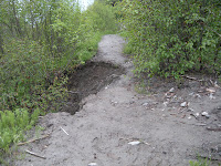
Minutes after we headed up the trail, I mentally began shaking my head. Who would let their 9-year-old kid race up a cliff?? I was a bit nervous myself as I saw the "trail," and I couldn't imagine letting 300 kids at it, unsupervised, to run 3/4 mile up a not-quite-vertical-but pretty-darn-close-to-it slope covered with loose rocks and mud. Hm. Obviously I'm not truly Alaskan or tough enough. You see the picture to the left. What do you think?? As we continued up I got a little more comfortable with the trail. "Trail," singular, is an oxymoron. There is more like 2 or 3 or 4 or more trails one can take up, so it is constantly a multiple choice. Which one is best? All of them were overhung with Devil's Club, pushki and whatnot. Some were slicker than others from the rain over the weekend. All were steep.

Let me pause for a moment and fill you in. This "race" is up the 3000 foot (give or take), 1 1/2 mile (one way) Mt. Marathon every year on July 4. If you're under 18 you're considered a junior and only have to go halfway, which still gets you above treeline. The race starts in town and there's about 7-10 blocks of running uphill on pavement before getting to the base of the mountain and the trail. Each year 300 kids, 300 women and 300 men are allowed to race to the top to see which maniac is fastest at managing not to kill or maim themselves and still get to the top and back down. So many people want the honors to run this race that there is a lottery held each year. Applications must be in by March 31. If you've run the race the previous year, ever won the race, or raced it more than 10 times you are exempt from the lottery and can get in. What spots are left are up for grabs.

Well, it took us an hour of f
requent stops to catch our breath, admire the view of Resurrection Bay and the Seward Harbor and attempt to ignore our burning calves to reach the half-way mark. We had to help 7-year-old Sonora and 9-year-old Darius up the cliff section, and they managed to not whine or complain too much. Then for the descent. Coming down is certainly faster than going up, but in some ways more nervewracking since the trail was loose scree, snow, and a creek. The "down" route follows a creek. The fastest way would probably be to plow right through the middle of the creek, though one would need to be cautious of slippery rocks. But then, I imagine that anyone who is serious about getting down fast doesn't care too much about falling on slippery rocks anyways. There was another little section of rock climbing that took a good 15 minutes to get the kids down, coaching them on every hand and foothold so they wouldn't go tumbling and take us out too. We walked through the creek part of the way as well.

People take this race very seriously. The parking lot just behind the Seward Hospital was full. There were old women in jogbras with not an ounce of spare flesh on them, parents interrogating their kids on how they did on their training run, and moms with kids in baby backpacks. Higher up people were practicing their descent technique. My cousin kept up a commentary much of the way up, coaching her 9-year-old on the right path to take, when to go fast, when to go slow, and more, since this will be his first time racing it. It all seemed a bit overwhelming. When we were done Ronna invited me to come and watch the race with them on July 4. I am curious and can't quite imagine it so we just might do it!

Gorgeous view of Resurrection Bay from partway up Mt. Marathon.

Wednesday, June 16, 2010

T.R.A.I.L.S. Work Day Across the Bay

View of part of Halibut Cove from the Alpine Ridge Trail with the Homer Spit in the background.


Two years ago we participated in the T.R.A.I.L.S. Work Day at Kachemak Bay State Park across the bay. It got us a cheap boat ride across the bay for a day of hiking and no work. This year we chose a different trail, hoping to get some work! Work we got, and the boat ride was even cheaper: $15 for adults and $5 for kids, for a grand total of $40 for the family, round-trip (as compared to $240 water taxi rates for the family). It was well worth it!

The work: We chose to help with some light brushing and trail work on the Saddle Trail off of Halibut Cove. A couple of Fish & Wildlife Service guys were waiting for us at our drop-off point. After teaching us the names, purposes and use of the tools we were to use, we all grabbed some and headed up the trail.

The Saddle Trail is a series of switchbacks that heads up a rugged slope above Halibut cove. After years of use the trail gets worn down and when it rains the water runs down the trail rather than across it. which can wash the trail right out. Our goals were to 1-clear brush from the sides of the trail and 2-flatten the trail so the water would run across it rather than down it. With a crew of 7 (9 including the Fish and Game guys) we fixed up the trail in 2 1/2 hours. Denver and I had loppers and lopped Devil's Club, elderberry, cranberry and alders up the half mile, while the rest of the crew grabbed shovels, rakes and whatnot and smoothed out the trail. A major project to reduce the steepness of the trail is in the works, extending the switchbacks for more gradual corners. That is a heavier job than we were equipped for so we just helped fix up the part of the trail that will continue to exist after being fixed up.

The hike: After we got done working at 11:30, the rest of the day was ours to explore as we liked till pickup by the water taxi at 4:30. We ate our lunch, then decided to check out the Lagoon Trail that roughly follows the shoreline from a few hundred feet up off the water's edge. It was quite a trek, with a hardly visible trail, fallen trees that we had to crawl under and bear scat every 50 feet or so (some quite fresh!). We didn't go far before we decided to turn back and explore another trail. The Alpine Ridge Trail is a 2.2 mile out and back trek. We probably only made it out a half mile or so. It was all steeply uphill and grueling for the person who was wearing the backpack (in this case, Doug). Not being accustomed to the climbing or the heat (it was probably 65 or so) we got some good pictures of Halibut Cove and then decided to head to the Grewingk Glacier and glacier lake.

Another view of Halibut Cove--the inside part at low tide. At high tide all the mud flats in the middle of the picture are covered with water, but it is still not passable by most boats except through the channel on the right side (hidden in this pic by the tree).

An easy, mostly level 1.1 mile hike got us from the top of the Saddle Trail to the Grewingk Glacier Lake. This is probably one of the more popular across the bay destinations, and as you can see from the picture, there were lots of people there that day! The kids waded in the water, played with icebergs, threw rocks, climbed rocks and enjoyed the warm, sunshiney day. Weather-wise, it was an awesome treat, as the last time we'd come on the TRAILS Day it was cool, blustery and rainy and we'd huddled under a tarp.


Halibut Cove has a year-round village (an artist's enclave), oyster farms, a restaurant, shopping, camping, Kachemak Bay State Park, awesome kayaking, sealife and more. Homes like the one picture here get supplies on ropes from the water. It is another world over there and a very neat place to visit. If we wanted to go more often we would have to buy a boat or be good friends with someone who owns a boat since ferry prices are prohibitive. We just saw the backcountry part of Halibut Cove on this trip; the village would be a many-hour hike away from where we were.

We got back to the Homer Harbor and saw Halibut Cove's namesake lying in the back of a truck. That is one big fish, though I doubt any halibut are left there anymore.

Wednesday, June 9, 2010

Climbing the Ridge


Ever since we moved to Homer 3 years ago I have wanted to climb the ridge that rises 1000 feet above the town of Homer. Also known as "the bench," we now live at the base of this ridge. I hear there are several trails up the ridge, though they start on private property so you need to know where there are and have the permission of the owners to cross their land. On one of our walks last year a neighbor told us that one trail starts on their property and they invited us to use it whenever we wanted. Aurora has bugged me to climb the ridge since we moved to our house, but the timing was never right. We were too busy in the fall, I had no desire to go up it in the winter, and then it was too mucky in the spring. Then the bears were coming out of hibernation and no one recommended going up there until they'd been out of hibernation a bit and had found food. We haven't had rain in a couple weeks and the pushki and other plants aren't too big yet so I decided today was the day.


We found the trail with no problem as our neighbors had marked it with a flag and weed-wacked the first 50 feet or so. After that first 50 feet, the trail was gone and we pretty much had to forage our own route up. If we climbed in the ravine there was more pushki and possibly boggy land. We opted to climb one of the spines of the ridge. In some places this was a nearly vertical climb. We were surrounded by pushki at the lower elevation and thorny wild rose bushes higher up. We would lose our balance at times and grab at the nearest shrub and discover we'd grabbed a handful of thorns. Ouch!

I was amazed to discover that the plants on the ridge were significantly further along than the plants in our yard. Lupine, forget-me-nots, wild geraniums and wild roses were blooming in profusion (the lupine has just come up in my yard), creating a beautiful mountain meadow feel. Even the pushki was a foot taller than just a few hundred feet lower at our place. This is probably because of the south-facing slope.

We took plenty of breaks as we planned our route up and scanned for bear or moose who might be crabby about our invading their territory. We got to the 'top' only to discover that the 'top' was a false one and we'd have a much longer hike if we wanted to get all the way up to Skyline Drive. The kids opted to enjoy the view, eat a snack and head back down.

Three years of itching to climb the ridge is thoroughly out of my system. Even the kids, who were so keen on the hike, said they don't want to do it again for awhile. One neighbor said their kids and grandkids snowboard the ridge in the winter. Aurora likes the thought, but I can't quite imagine climbing it with snow if it was that difficult climbing without snow! I'm out on the count on whether I'm going to let that happen!

The view from on the ridge.
Grewingk Glacier is on the far left of the Kenai Mountain Range.

Sunday, June 6, 2010

Diamond Creek Trail

Diamond Creek near the beach

One of our favorite hikes around Homer is the Diamond Creek Trail a few miles north out of Homer on the Sterling Highway. An unmarked gravel track across the road from the Diamond Ridge Rd. traverses a mile or so down and around to a trailhead. Oftentimes the parking lot is full and we've had to find a parking spot up the road at a pull-off.

The trail begins in an alder and pine forest with no view, but once you head around the first curve the panorama of Cook Inlet spreads out in front of you as the trail opens up with the gorge Diamond Creek cuts through. Over the past couple years mudslides have wiped out the trail a couple times and now erosion is cutting away at the trail, eating away at it. The first time we took this trail we were nervous as the trail drops off 50 feet or more down to the creek with no guardrail. With time we got used to the dropoff and just enjoyed the view.

Part of the fun of Diamond Creek is the geology. As you descend, you can see the different layers of stone in the cut. Another part of the fun is where the creek comes out onto the beach at the bottom. It is a kiddie playland, with logs criss-crossing the stream, big rocks, waterfalls and more. It is a common occurance to see sea otters a few feet off the shore while we sit and take in the sunshine, as well as eagles, cormorants and other birds. The kids love climbing the cliffs, though that could be a risky enterprise as 'slumps' are common when part of the cliff just drops off (in fact, a friend had one fall right over her head; close call!) and heads the direction of the beach.

The hike back up is a good workout, but not so long that it wipes us out. This is a favorite trail in part because many of the trails around Homer are boggy and take awhile to dry out enough to hike, but this one manages to be hikeable earlier than most. The kids enjoy the beach and this hike can be extended to whatever length one wants by hiking out and back on the beach either towards Homer or towards Anchor Point.