 |
| The trail starts off with level gravel |
 |
| But in places it gets narrow and rocky |
The official trail map shows these features, which I got pictures of:
 |
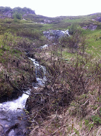
| The bridge, at .8 mile, has a typical rushing Alaskan stream |
 |
| Marmot Meadows acutally does have marmots. I saw three, but was not quick enough or close enough to get pictures. |
 |
| Looking at the bottom of the cliffs |
We had planned to hike to the Top of the Cliffs. The map says it's at 2.4 miles, a couple thousand feet elevation from the Visitor's Center. Piece of cake. We'd be back to Seward to pick up Aurora in a few hours, after her climb up Mt. Marathon. Either we were really tired that day, or that hike was harder than we expected, but by time we reached the top of Marmot Meadows, we were ready to turn back. There was a nice overlook there !where I got a video of Exit Glacier, and by that point we'd gotten on jackets to ward off the chilly wind.
 |
| Exit Glacier from top of Marmot Meadows |
We would do this hike again, but will be more prepared for a challenging hike (4000 foot climb over 4 miles, one way), for crossing snowfields, and for lots of people!
This video starts at the base of Exit Glacier and has a view of the Cliffs.
No comments:
Post a Comment