Our introduction back into civilization after camping, hiking and biking for 3 days was the pull-off at the bridge where the road to Hope cuts off. There is an 8-mile or so stretch of beautifully paved bike path from the Hope Bridge (I don't know if that's the formal name but I'm going to call it that), following alongside the Seward Highway from the cutoff to the Johnson Pass trailhead. I've often wanted to bike it but have never had my bike or the time to do it. We decided it would be a nice, mellow thing to do before we headed home. The bike ride was mellow and fun, but the parking area was insane!
We've driven by and noticed two coffee trucks parked in that parking area before and wondered how they ever got enough business to sustain themselves way out there, well over an hour south of Anchorage and in the middle of, quite literally, nowhere. Now we know. From the time we pulled into that parking lot, tour bus after tour bus stopped, spit out folks who queued up for either the bathrooms or the coffee shops, snapped a few pictures, got back on their bus and away they flew up the road to Anchorage or down the road to Seward. RV after RV, campers, cars and more streamed in with people getting their pictures taken with the view. Doug and I looked at each other, puzzled. The view was so boring compared to most views we see in Alaska--rolling hills (not even mountains) with a river rushing by (which you couldn't see in the picture anyways). No peaks, no snow, no cliffs--none of the stuff we would expect someone to get a picture of.
So we crashed this tourist party with our grimy, smokey selves, got on our bikes and enjoyed the ride. As long as you can ignore the highway with tons of traffic zooming by (day after the Fourth, and a Friday, and the beginning of dipnetting season on the Kenai Peninsula), it is a very pleasant ride. We had a headwind the whole way out so I was looking forward to turning around and getting that wind on my back. There were rolling hills and then flat sections, which we discovered when we finally did turn around that the flat sections were actually gradual uphills, so gradual we hadn't realized we were going uphill. So when we turned around we cruised. It was so sweet!!
We went almost 7 miles out and then back, so a nice 14 miles. It was just about right. Granite Creek Campground is right along this section of paved trail and Johnson Pass is at one end of it so we very well may be back again. I don't know if I have ever, in 6 years of driving along here, have seen anyone biking or walking on this bike path. But then, when I'm driving I only go by for a few minutes every month or so so I could easily miss other users. We had it to ourselves. I don't think I'd want to rollerblade it: we were going 20 mph on our bikes and I just don't see myself braking that on rollerblades!
Monday, July 8, 2013


Palmer Creek Road: Old Mine and Waterfalls
Our style of exploring new places is to drive down random roads that look interesting to see where they go. The first time we drove down Palmer Creek Road, it was only my stubbornness that kept us going the 7 miles to the campground (Coeur d'Alene). I'm glad I was stubborn because in chatting with a lady at the campground we discovered that the road, that continues 5 miles past the campground (though significantly rougher), heads up to an old mine and a waterfall. Thus, after hiking 10 miles out to Gull Rock, getting some food in us back in camp, the restless kids talked us into driving back up Palmer Creek Road to check out the mine.
Trails.com has a wonderful, succinct description of this area that I copy here:
"High in the hills above the old mining community of Hope is the scenic valley of Palmer Creek. Here, waterfalls and weathered hemlocks punctuate the rolling tundra. Higher yet, a hanging valley cradles two alpine lakes. This is a delightful day trip for children and agile grandparents alike. The only sobering note is the last 5 miles of road—high, narrow, winding, and slow, but normally drivable in dry weather by passenger cars. The road is unsafe for large campers and trailers but is good for mountain bikes. Gold was first discovered along Palmer Creek by George Palmer in 1894. A rush to the Turnagain goldfields took place in 1896. Two towns, Hope and Sunrise, grew out of the rush, and as many as 5,000 people were reported living in the area in 1898. Palmer Creek was the site of early placer mining and, later, lode mining, beginning in 1911 with the Lucky Strike vein. The Lucky Strike and Hirshey Mines figure in the hikes offered here. Active mining continued into the 1930s, and some people still have claims in the area today."
 |
| The view towards the mine from where the road was blocked off and we hiked. |
"High in the hills above the old mining community of Hope is the scenic valley of Palmer Creek. Here, waterfalls and weathered hemlocks punctuate the rolling tundra. Higher yet, a hanging valley cradles two alpine lakes. This is a delightful day trip for children and agile grandparents alike. The only sobering note is the last 5 miles of road—high, narrow, winding, and slow, but normally drivable in dry weather by passenger cars. The road is unsafe for large campers and trailers but is good for mountain bikes. Gold was first discovered along Palmer Creek by George Palmer in 1894. A rush to the Turnagain goldfields took place in 1896. Two towns, Hope and Sunrise, grew out of the rush, and as many as 5,000 people were reported living in the area in 1898. Palmer Creek was the site of early placer mining and, later, lode mining, beginning in 1911 with the Lucky Strike vein. The Lucky Strike and Hirshey Mines figure in the hikes offered here. Active mining continued into the 1930s, and some people still have claims in the area today."
 |
| A stream crossing aided by old mining paraphernalia. The trail up to the falls goes right up this slope. |
 |
| Leftovers from the old mine. A couple pipes were alternately buried and exposed on the hillside up to the mine. |
 |
| A view of the valley we'd just come up (driven and hiked), from just below the mine entrance. |
 |
| The mine was up 2 more switchbacks from where we stopped (14 miles of hiking that day took their toll on me!). |
 |
| The mountains above us were shrouded in fog, with an old stone building in the foreground. |
Gull Rock Trail in Hope, AK
We woke up to our first morning in Hope to scattered showers as well as to sore, tired muscles. We'd all slept in late and it didn't look like Hope Point was going to happen so we considered some alternatives: Gull Rock hike or the old mine up Palmer Creek Road. Turns out we would do both, but at the time we didn't know that.
From the Porcupine Campground, a very nice, graveled trail connects to the Gull Rock trail, a 5-mile trek out to, we assumed, Gull Rock. What the significance of the rock was, we didn't know. Because the beginning of the trail was so nice and Aurora was itching for another long run (15 miles the day before on the Lost Lake Trail wasn't enough apparently), we decided we would bike it and Aurora would run.
It was somewhere between mile 1 and 2 that we ditched our bikes in the woods on the side of the trail and decided to hike the rest of the way. Once again, rocks and roots were our demise. It would have been a difficult trail to bike as there were talus slopes to cross, boggy sections, and overgrown spots. There was about an 800 foot elevation change over the course of the trail, but they were long, gradual climbs or descents mostly so that was less of an issue. But we were tired from the day before and had less patience with climbing off our bikes often. There was one section that was very sweet--a pine-needle-covered gradual trail that was smooth, though there was not much room for error as one side was a steep drop down towards Turnagain Arm.
It was a long 5 miles. Some trails just zip along and feel like quick jaunts, but this felt long. When we arrived at Gull Rock we were disappointed. There were no gulls, and there was no special view or scenery or rocks or anything. It seemed underwhelming. We walked all the way out to the point, ate our lunch (we'd been thinking this would be a quick little 10 mile bike ride so had just thrown yesterday's leftovers in a backpack), snapped the obligatory I-did-this-and-I-can-prove-it picture, and headed back, threading past a few camping sites. In fact, the scenery was so unimpressive we didn't even take a picture of the view.
The trek back felt just as long as the way out, though was better because we knew how far we had to go. This is one of those hikes that we would only do again if we were absolutely desperate for a hike. There were no impressive views since though we followed the shore the trees blocked the scenery. When we did get a peek, it was incongruous to see the Seward Highway across Turnagain Arm. It felt like we were so far away from civilization, and yet just across from Gull Rock we could see Anchorage, and jets flew over regularly as they headed into the airport there. This would be a hike just to hike, and definitely not a bike!
From the Porcupine Campground, a very nice, graveled trail connects to the Gull Rock trail, a 5-mile trek out to, we assumed, Gull Rock. What the significance of the rock was, we didn't know. Because the beginning of the trail was so nice and Aurora was itching for another long run (15 miles the day before on the Lost Lake Trail wasn't enough apparently), we decided we would bike it and Aurora would run.
It was somewhere between mile 1 and 2 that we ditched our bikes in the woods on the side of the trail and decided to hike the rest of the way. Once again, rocks and roots were our demise. It would have been a difficult trail to bike as there were talus slopes to cross, boggy sections, and overgrown spots. There was about an 800 foot elevation change over the course of the trail, but they were long, gradual climbs or descents mostly so that was less of an issue. But we were tired from the day before and had less patience with climbing off our bikes often. There was one section that was very sweet--a pine-needle-covered gradual trail that was smooth, though there was not much room for error as one side was a steep drop down towards Turnagain Arm.
It was a long 5 miles. Some trails just zip along and feel like quick jaunts, but this felt long. When we arrived at Gull Rock we were disappointed. There were no gulls, and there was no special view or scenery or rocks or anything. It seemed underwhelming. We walked all the way out to the point, ate our lunch (we'd been thinking this would be a quick little 10 mile bike ride so had just thrown yesterday's leftovers in a backpack), snapped the obligatory I-did-this-and-I-can-prove-it picture, and headed back, threading past a few camping sites. In fact, the scenery was so unimpressive we didn't even take a picture of the view.
 |
| Lunch break on Gull Rock. |
Sunday, July 7, 2013
Hope, Alaska
We've been through Hope before, but have never stayed there. Last year on our vacation we'd climbed Hope Point, but hadn't quite made it to the peak of the 3630 foot climb. Ever since Denver has been bugging us to get back there and do it again--making it to the top this time--so after we did the Lost Lake/Primrose Trail we headed up to the Porcupine Campground in Hope to camp for a few days, hoping the rain on the forecast would lighten enough for us to attempt the climb. Hope Point was encased in fog nearly all of our time in town, though ultimately it was our strenuous schedule and physical fatigue that kept us from attempting it. However, it was a great trip because we got to explore Hope!
First of all, there is virtually nothing to Hope, Alaska. There might have been something like a convenience store, but not a grocery store. They have a library that also appeared to be a secondhand store, ice cream shop and espresso shop. They have a lot of OLD buildings--like, from the early to mid-1900's, which is rare in Alaska. There are 3 restaurants (maybe 4--one might be open only in the winter; it is called Winter Cafe). There are 3 campgrounds (more on that later), 2 ATM's apparently (that's a long story how I know that--our campground neighbors arrived without money expecting the campground would take credit cards.....so off they went in search of an ATM!), and a gas station that I was pretty doubtful about (it looked like a wooden shack that maybe had a pump inside?? There was a Tesoro sign out front and they said they had gas but it wasn't quite clear where to go to get it....). They have a school, but last I heard they only had 7 students and if they didn't get their enrollment up to like 10 they were going to close the school. Not sure what happened to it, but obviously the school building is still there.
The big thing that I think keeps Hope alive is Resurrection Pass, which traverses 38 miles from Cooper Landing to Hope and is a popular recreational path for mountain bikers, runners, hikers, backpackers, horseback riders, hunters and in the winter, snowmachiners.
Whenever we explore these little towns, trying the restaurants is high on our list. On Main Street we found a cafe (I'm afraid I didn't get the name of it as it just said, "Cafe" on the outside) that was one of those very old buildings. It certainly had a lot of character, and I was startled to see an entire wall devoted to a bookshelf filled with books when we first walked in. The tables were large, the prices were reasonable and the food just okay. My veggie burger was undoubtedly out of a box, the Coke was in a can, and they had bean-less chili which fascinated my daughter so much she ordered it.
We also wanted to try Discovery Cafe, but it closed at 3 p.m. the days we were there and we were always out and about adventuring past 3 so we never made it back in time. We'll put that one on our list for "next time" (and there will be a next time!). It is also in an old building--very quaint looking--along the main road into town.
Porcupine Campground was closed last year for remodeling. It was very nice with a paved road and paved parking at each site, bear boxes for the tent campers, and new restrooms. It was $18/night, and they charged $5 per extra vehicle, so it was $46 to stay there 2 nights. The campground is in a birch forest with the usual profusion of bushes and shrubbery so it was fairly private, particularly the tent sites that were down little trails from the parking spot. The RV spots are on a reservation basis and when I'd check a week before we went they were 100% booked. However, I noticed that there were tent-only sites that were on a first-come, first-serve basis so we'd decided to take our chances and hope we got a spot. When we pulled in in late afternoon on the day before the Fourth, we got the second to last spot available out of the 24. Whew! The other nearby campground was on Main Street with no trees for protection from the winds ripping along Turnagain Arm.
Coeur d'Alene is a free campground with 6 sites, but it is 7 miles down Palmer Creek Road, way off the beaten path. It is a cute little place, with a stream running through the campground, a bridge over it, tucked into a little knoll. I could see going out there if I really wanted a wilderness experience and didn't want to run into town to check out the restaurants or if I wanted to explore the nearby mountains.
So that is Hope. I think the hope for gold is what started this little village. Few people drive the 15 miles off the Seward Highway to check it out, but it is a cute little place with some good hiking (Gull Rock, Hope Point, the Resurrection Trail and the old mine and falls). We'll be back because we need to climb Hope Point, we may want to explore the old mine and mountains above it (more on that in another blog post), and we'll be doing Resurrection Pass again sometime. Plus we have to check out Discovery Cafe!
 |
| Old, picturesque buildings are an attraction in Hope. This one, built around the turn of century, has been updated with a covered entryway (and car!) |
First of all, there is virtually nothing to Hope, Alaska. There might have been something like a convenience store, but not a grocery store. They have a library that also appeared to be a secondhand store, ice cream shop and espresso shop. They have a lot of OLD buildings--like, from the early to mid-1900's, which is rare in Alaska. There are 3 restaurants (maybe 4--one might be open only in the winter; it is called Winter Cafe). There are 3 campgrounds (more on that later), 2 ATM's apparently (that's a long story how I know that--our campground neighbors arrived without money expecting the campground would take credit cards.....so off they went in search of an ATM!), and a gas station that I was pretty doubtful about (it looked like a wooden shack that maybe had a pump inside?? There was a Tesoro sign out front and they said they had gas but it wasn't quite clear where to go to get it....). They have a school, but last I heard they only had 7 students and if they didn't get their enrollment up to like 10 they were going to close the school. Not sure what happened to it, but obviously the school building is still there.
The big thing that I think keeps Hope alive is Resurrection Pass, which traverses 38 miles from Cooper Landing to Hope and is a popular recreational path for mountain bikers, runners, hikers, backpackers, horseback riders, hunters and in the winter, snowmachiners.
Whenever we explore these little towns, trying the restaurants is high on our list. On Main Street we found a cafe (I'm afraid I didn't get the name of it as it just said, "Cafe" on the outside) that was one of those very old buildings. It certainly had a lot of character, and I was startled to see an entire wall devoted to a bookshelf filled with books when we first walked in. The tables were large, the prices were reasonable and the food just okay. My veggie burger was undoubtedly out of a box, the Coke was in a can, and they had bean-less chili which fascinated my daughter so much she ordered it.
We also wanted to try Discovery Cafe, but it closed at 3 p.m. the days we were there and we were always out and about adventuring past 3 so we never made it back in time. We'll put that one on our list for "next time" (and there will be a next time!). It is also in an old building--very quaint looking--along the main road into town.
Porcupine Campground was closed last year for remodeling. It was very nice with a paved road and paved parking at each site, bear boxes for the tent campers, and new restrooms. It was $18/night, and they charged $5 per extra vehicle, so it was $46 to stay there 2 nights. The campground is in a birch forest with the usual profusion of bushes and shrubbery so it was fairly private, particularly the tent sites that were down little trails from the parking spot. The RV spots are on a reservation basis and when I'd check a week before we went they were 100% booked. However, I noticed that there were tent-only sites that were on a first-come, first-serve basis so we'd decided to take our chances and hope we got a spot. When we pulled in in late afternoon on the day before the Fourth, we got the second to last spot available out of the 24. Whew! The other nearby campground was on Main Street with no trees for protection from the winds ripping along Turnagain Arm.
Coeur d'Alene is a free campground with 6 sites, but it is 7 miles down Palmer Creek Road, way off the beaten path. It is a cute little place, with a stream running through the campground, a bridge over it, tucked into a little knoll. I could see going out there if I really wanted a wilderness experience and didn't want to run into town to check out the restaurants or if I wanted to explore the nearby mountains.
So that is Hope. I think the hope for gold is what started this little village. Few people drive the 15 miles off the Seward Highway to check it out, but it is a cute little place with some good hiking (Gull Rock, Hope Point, the Resurrection Trail and the old mine and falls). We'll be back because we need to climb Hope Point, we may want to explore the old mine and mountains above it (more on that in another blog post), and we'll be doing Resurrection Pass again sometime. Plus we have to check out Discovery Cafe!
Ptarmigan Creek Trail and Campground

As a base close to the Lost Lake/Primrose Trails, Ptarmigan Creek Campground worked out very well, just 10 minutes or so from the Primrose Trailhead. It is a quiet little campground--16 fairly private sites and not very busy the night we were there a couple days before the 4th of July. We stayed in this campground before years ago, maybe even on our visit to Alaska before we moved here, and I recalled a trail heading out of the campground that I wanted to check out. So once we got registered for the night, we packed up a backpack with snacks and rain gear and headed out.
We didn't know how long the trail was...or how difficult. Luckily the trail was very moderate with just rolling hills as it traversed first the river bottom along Ptarmigan Creek and then the hillsides as the trail cut across mountains towards the source of the creek: Ptarmigan Lake. The first section of the trail was in amazing condition: a fresh bed of gravel contained by wood boards on each side. I can think of only a few trails that are this nice of all the trails I've hiked in Alaska. After a cutoff to either the lake or a mine road, the trail became the typical Alaska trail: a single dirt track with lots of plants hanging over it--Alaska's summer jungle. Some overgrowth is worse than others (like pushki that causes blister burns, or grass that towers over our heads), but this was not bad and we only noticed it in a few places.
It was evening, we hadn't had dinner yet and we didn't know how far the trail went, but with our typical stubbornness, we persisted. Having hiked in the mountains before, we saw the signs that looked like there was a lake around the next curve of the mountain. Sure enough, it was, there, but it still took us 30 minutes to get there from the time we spotted it.
 |
| Ptarmigan Lake--a gorgeous, glacial blue alpine lake 3 1/2 miles long |
Honestly, though, this trail is going to be on my destination list again. It is a gem. The trail is easy and the lake is beautiful, with hanging glaciers gracing the peaks above it. Even Denver told me to remind him to bring it up with his Boy Scout troop as a potential trip. So our evening excursion proved fruitful and enjoyable, and the rain which had been pelting us when we pulled into the campground held off so we stayed dry. This little adventure ended well.
Lost Lake-Primrose Trail--Running and Biking It!
A couple years ago when we backpacked Johnson Pass, Aurora got it in her head that she wanted to run it--23 miles! Last summer was too busy, but we decided this summer we would make it happen. My motherly prudence told me we ought to try something a little shorter first, so I thought the Lost Lake/Primrose Trail near Seward would be perfect: I'd backpacked it last year and the trail was in good condition and it was only 15 miles (14.8 to be exact). Ha. Well, it was quite the ride. Here's the story.
We started by dropping Douglas and Aurora off at the southern end, the Lost Lake Trail, which begins nearly in Seward. I'm not sure why we decided to do it south to north, but it ended up being a very good thing for Douglas, though not so good for Denver and I, as you will soon read about. Douglas was the one loaded up: food, water, extra clothes, gear for the bike. It seemed like an epic to make sure we had everything. The night before we'd each packed a ziplock bag with our food of choice: granola/energy bars, dried fruit, nuts, apples, fruit smoothie, summer sausage/cheese/crackers. The Camelback was filled with water with a couple water bottles to supplement it. The bike pump was attached. Everything was checked, double checked, and after a quick picture to commemorate the event, away they went.
Denver and I promptly hopped in the car and drove to their ending place, which was to be our starting spot. We were going to bike up the north end, or the Primrose Trail (for some reason the trail names change at the halfway point so it is the Lost Lake Trail on the southern 7.3 miles and the Primrose Trail for the northern 7.5 miles) and meet them.
When backpacking last summer on the section we were going to bike, I recalled the trail being smooth and easy, with only a few steep spots up near the top before breaking out of the trees. I must have only recalled the first 20 minutes of hiking, which was delightfully smooth. Soon enough, though, the trail got rocky with large roots protruding across the trail. It didn't take us long to let our egos take the back seat and we just hopped off our bikes when an intimidating hill loomed ahead of us: uphill, criss-crossed by roots and pocked by rocks.
We've biked a little bit this summer, but not heavy duty backcountry trails. Plus we'd just gotten off a month of fairly sedentary vacation, so we were not in shape. Nor were we mentally prepared for the rough ride. We just kept getting off our bikes and walking up or around the unbikeable sections. We took frequent breaks, sometimes just standing by our bikes gasping, other times plopped down in the moss along the trail. At one point we stopped and checked out an old cabin along the trail. We skipped the trail turnoff to the waterfall, marked by a 3-rock cairn, not wanting to take a break quite that long.
We decided that our goal was to get above treeline. Just minutes after we broke out of the trees, Aurora came running at us from the south, and then Douglas came over the rise, biking through the misting rain. Aurora was in fine shape--not tired and very happy. Douglas was tired. Apparently nearly the entire trail from the beginning to the point where they met us was uphill besides a few small downhills (some that had to be walked down!). I think he was too tired to chew me out for underestimating how far uphill it was. Aurora was ahead of him the whole way, besides the times he made her push the bike! It was a long 1800 foot climb for him, though it was smoother for him than it had been for us and he'd rarely had to get off.
We all took a break and Denver and I had our lunch (read: more substantial snack). Then we turned around and headed back the way we'd come. Aurora took off, her running pace being far faster than our biking pace even downhill. In the first 10 minutes we were off our bikes quite a few times, walking down slick, muddy rocks, over patches of snow and dropoffs below tree roots. Aurora patiently would wait up for us every so often. We hardly had to pedal the whole way down it seemed (think--1800 feet in 5 1/2 miles), but we had to brake nearly constantly the whole way down too.
Even with controlling our speed it was a wild ride. I fell off my pedals a number of times while standing on them going over the big roots (very grateful I am a female--hitting that middle bar is not comfortable either way!). My 29" tires, which are great for going over things, are not as great at maneuvering around rocks and such, so it was a bit gnarly. We all made it down in one piece, though as we found out later, our bikes did sustain some damage. Our bike mechanic shook his head when he heard of our adventure and said, "That is one trail that is faster to run than bike!
So Douglas and Aurora did the whole thing in just over 4 hours including breaks, and Denver and I did about 11 miles (5 1/2 out, 5 1/2 back) in just under 4 hours. It was....an adventure! I don't have any inclination to do that again, but this blog entry will be my memory-jogger in case I ever do consider it!
I will say that when you're mountain biking a trail like this your complete attention is on the trail at all times so we had no time to look around and enjoy the scenery. It was fast, intense and engaging, but we gave up some of the appreciation of the area by doing it that way. I think that I would not want to do a trail like this only mountain biking. I would want to hike it too in order to actually feel it and see it as opposed to just traverse its length. And next time I hike a trail I'll notice the trail in terms of it's bikeability. I totally did not notice those roots and rocks when I backpacked this trail just one year ago. If I had, we might not have biked it!
We started by dropping Douglas and Aurora off at the southern end, the Lost Lake Trail, which begins nearly in Seward. I'm not sure why we decided to do it south to north, but it ended up being a very good thing for Douglas, though not so good for Denver and I, as you will soon read about. Douglas was the one loaded up: food, water, extra clothes, gear for the bike. It seemed like an epic to make sure we had everything. The night before we'd each packed a ziplock bag with our food of choice: granola/energy bars, dried fruit, nuts, apples, fruit smoothie, summer sausage/cheese/crackers. The Camelback was filled with water with a couple water bottles to supplement it. The bike pump was attached. Everything was checked, double checked, and after a quick picture to commemorate the event, away they went.
Denver and I promptly hopped in the car and drove to their ending place, which was to be our starting spot. We were going to bike up the north end, or the Primrose Trail (for some reason the trail names change at the halfway point so it is the Lost Lake Trail on the southern 7.3 miles and the Primrose Trail for the northern 7.5 miles) and meet them.
When backpacking last summer on the section we were going to bike, I recalled the trail being smooth and easy, with only a few steep spots up near the top before breaking out of the trees. I must have only recalled the first 20 minutes of hiking, which was delightfully smooth. Soon enough, though, the trail got rocky with large roots protruding across the trail. It didn't take us long to let our egos take the back seat and we just hopped off our bikes when an intimidating hill loomed ahead of us: uphill, criss-crossed by roots and pocked by rocks.
 |
| One of the sections of trail, nearing the top where we broke out of the trees. |
We've biked a little bit this summer, but not heavy duty backcountry trails. Plus we'd just gotten off a month of fairly sedentary vacation, so we were not in shape. Nor were we mentally prepared for the rough ride. We just kept getting off our bikes and walking up or around the unbikeable sections. We took frequent breaks, sometimes just standing by our bikes gasping, other times plopped down in the moss along the trail. At one point we stopped and checked out an old cabin along the trail. We skipped the trail turnoff to the waterfall, marked by a 3-rock cairn, not wanting to take a break quite that long.
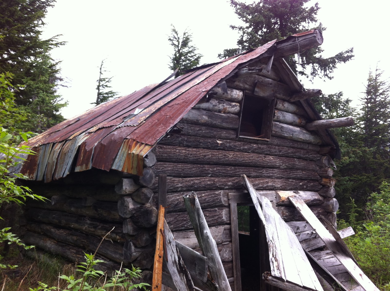 |
| An old cabin along the Primrose Trail. |
 |
| The first patch of snow we come across in the summer is always cause for a snowball or two! |
Even with controlling our speed it was a wild ride. I fell off my pedals a number of times while standing on them going over the big roots (very grateful I am a female--hitting that middle bar is not comfortable either way!). My 29" tires, which are great for going over things, are not as great at maneuvering around rocks and such, so it was a bit gnarly. We all made it down in one piece, though as we found out later, our bikes did sustain some damage. Our bike mechanic shook his head when he heard of our adventure and said, "That is one trail that is faster to run than bike!
So Douglas and Aurora did the whole thing in just over 4 hours including breaks, and Denver and I did about 11 miles (5 1/2 out, 5 1/2 back) in just under 4 hours. It was....an adventure! I don't have any inclination to do that again, but this blog entry will be my memory-jogger in case I ever do consider it!
I will say that when you're mountain biking a trail like this your complete attention is on the trail at all times so we had no time to look around and enjoy the scenery. It was fast, intense and engaging, but we gave up some of the appreciation of the area by doing it that way. I think that I would not want to do a trail like this only mountain biking. I would want to hike it too in order to actually feel it and see it as opposed to just traverse its length. And next time I hike a trail I'll notice the trail in terms of it's bikeability. I totally did not notice those roots and rocks when I backpacked this trail just one year ago. If I had, we might not have biked it!
Monday, July 1, 2013
Bear Viewing...NOT!
Some relatives were visiting us last week from the Lower 48 and wanted to go on a Bear Viewing tour. I called around and worked out a good deal with one of the companies to take the five of us to Katmai National Park last Friday. We were to arrive there at 7:30 a.m., but told to call first in case there were weather delays.
Well, weather delays there were. The cloud cover was too low over at Katmai when I called at 7:15 a.m. so they said call back in an hour. I called back in an hour and got the same report. I called back another hour after that, and another hour after that. In Homer it was perfectly calm out, which is usually great for flying but it meant the cloud cover was too stable and not moving, and with the float planes, they need good visibility, combined with just the right tides since they land on the ocean.
Finally they said Katmai was off for the day, but they could take us to Lake Clark instead. The pilot would be our guide instead of the permanent on-ground staff, and the plane ride would be 45 minutes instead of an hour. We would still get 3 hours on the ground viewing the bears. By time I consulted with my cousins and then called back the company, the cloud cover had lowered and a float plane that had just tried to land at Lake Clark was unable to land so that was called off too.
It seemed a bit grueling to have our day on hold like that, wondering hour by hour if we were going to be able to go. We could have tried for Saturday but the weather report was not optimistic and my relatives didn't feel like going through that again. I can see that there are a lot of things to factor in with these trips: weather in Homer, weather across Cook Inlet, tides, wind, cloud cover.....plenty of things could conspire to call off a trip. This was one of the things my relatives really wanted to do on their trip to Alaska so I was very disappointed for them. On the other hand, it might give them an excuse to come back to Alaska and visit again! As for me, I was looking forward to a really cool blog post with awesome pictures of bears, but I guess that will have to wait till some other relatives come to visit and give me an excuse to do this again!
Well, weather delays there were. The cloud cover was too low over at Katmai when I called at 7:15 a.m. so they said call back in an hour. I called back in an hour and got the same report. I called back another hour after that, and another hour after that. In Homer it was perfectly calm out, which is usually great for flying but it meant the cloud cover was too stable and not moving, and with the float planes, they need good visibility, combined with just the right tides since they land on the ocean.
Finally they said Katmai was off for the day, but they could take us to Lake Clark instead. The pilot would be our guide instead of the permanent on-ground staff, and the plane ride would be 45 minutes instead of an hour. We would still get 3 hours on the ground viewing the bears. By time I consulted with my cousins and then called back the company, the cloud cover had lowered and a float plane that had just tried to land at Lake Clark was unable to land so that was called off too.
It seemed a bit grueling to have our day on hold like that, wondering hour by hour if we were going to be able to go. We could have tried for Saturday but the weather report was not optimistic and my relatives didn't feel like going through that again. I can see that there are a lot of things to factor in with these trips: weather in Homer, weather across Cook Inlet, tides, wind, cloud cover.....plenty of things could conspire to call off a trip. This was one of the things my relatives really wanted to do on their trip to Alaska so I was very disappointed for them. On the other hand, it might give them an excuse to come back to Alaska and visit again! As for me, I was looking forward to a really cool blog post with awesome pictures of bears, but I guess that will have to wait till some other relatives come to visit and give me an excuse to do this again!
Subscribe to:
Posts (Atom)