Thursday, October 9, 2014

Final Harvest


Early October garden harvest

We have had a couple weeks of sunshine recently after a 6-week stretch of rain, rain, rain in August and September. Clear nights have meant cold nights and frost, leading to the impending harvest that must happen soon! Every year the state cross-country running meet happens the first weekend of October, which is the perfect time to harvest. So each year I've had to decide:  harvest the week before state or chance frozen ground the week after? This year I decided to spread my chances, partly because I've been very busy and finding time to harvest the whole garden is next to impossible. With both the kids in sports and not getting home till late each night, plus a heavy load of homework and their being gone every weekend, there was no chance of their help.

So a few days before heading to the state XC meet last week I dug 4 rows of potatoes. They were short rows; each 2 rows filled up a 5-gallon bucket. Every year I waffle between washing the potatoes and then drying them and putting them away, or just pulling them out of the ground and storing them dirty. There are pros can cons both ways. This year time was my deciding factor; it was all I could do to dig them, so the buckets went into the bathroom in my cabin (not quite a root cellar temperature, but pretty chilly) with a towel to cover and protect them from sunlight. I pulled up the remaining 15 or so onions; we've been harvesting onions from the garden since July so we've gotten 3 months of onions out of it. I just love being able to run to the garden to get an onion and not deal with the mess and mold of onions going bad in my cupboard! The final beets were pulled and cooked up for the kids' pre-race meal (a tradition we began this season; I need to plant more beets next year as I had to supplement ours with other folks' to keep my kids in beets).

Pulling up the broccoli and zucchini plants which had been frosted in the garden took only a moment.  In the greenhouse the zucchinis, green beans, lettuce, parsley and final head of cabbage were still looking good so I left them, pulling out the tomato plants. All the green tomatoes are on a tray in my kitchen and are ripening a few a day.

After an exciting and eventful weekend, with the Homer girls winning the state championship and the boys taking third, I was back home to a garden and greenhouse that had been heavily frosted. Outdoors the carrots had finally drooped a little and the potato plants were skeletons. The hardy kale continues on indifferent to the temperatures. I heard someone threw a tarp over their kale in Homer last winter and had fresh kale all winter long. That is my goal (as you can see in the picture--the tarp is on a section of the row)! I love massaged kale (olive oil, lemon juice, pepper, salt and cayenne pepper massaged into the kale till it is half the size; sprinkle with toasted pecans and craisens) and was craving it in the 4 days I was away from home over the weekend. Only problem will be shoveling a path through the snow to get through the moose fence into the garden area!

I dug the final 2 rows of potatoes and had to crack the frosted, frozen ground off them. Most of the carrots came sliding right out of the ground--except in a few places where the ground was frozen hard and deeper and it took some work with the shovel to detach the carrots from their home. Time was of essence once again and so the carrots stayed in the wagon in the lean-to for a few days covered with a towel until I could snap off the tops. Lazy year means they are not washed either, so we'll have to do that when we have more time. We ended up with 3 full 5-gallon buckets of potatoes, which will get us through till April or so probably, and 1 full 5-gallon bucket of carrots, which will probably last a couple months along with the 40 pounds we bought from the McNeil Canyon School carrot fundraiser.

The greenhouse was also pretty much toast, with only the parsley and lettuce (surprisingly!) still looking perky. That too took only moments to clean out, and the plants all went into the compost bin with some water dumped on them to help along the decaying process.


The morning of our first frost last week, with the yard ringed in fluffy fireweed
So the kale is staying in all winter and I'm excited about that. I'll keep picking parsley till it is frosted beyond use; have to remember to water it every now and again as it is all that's left in the greenhouse after I picked the lettuce plants clean last night by headlamp. It's that time of year when things are getting darker and I might be able to hunker down and get some things processed at night.

Once again--a successful garden season!

Saturday, September 6, 2014

Tyvek Camper--Strange Things in Homer

Every so often I see things that, even 7 years after moving here, I think, "That is so Homer!" or "That is so Alaska!" 

Driving through Barb's Video parking lot the other week, even the kids said, "You should blog about that, mom!" when they saw the Tyvekked camper. So here it is--just a picture of one of those weird things you might not see just anywhere!

Had to chuckle at this

Jakolof Revisted and Biking to Seldovia

A friend from Anchorage was coming down to visit for Labor Day weekend so I thought it would be fun to stay at the Wharf Cottage across the bay in Jakolof, and maybe pick some berries, and do some tidepooling. I had the bright idea of taking the bikes and biking to Seldovia from Jakolof. I wanted to load my friend up with memories and adventures, and I think that is just what happened. Here's how it worked out.

The Wharf Cottage just off the dock at Jakolof Bay
The weather dawned gorgeous--sunny and about as calm as it ever gets so we were stoked. With Mako's Water Taxi we got to ride a landing craft since they were dropping a lot of folks on beaches. It had plenty of room for our bikes, which I was pleasantly surprised to discover there was no extra charge for.

The Wharf Cottage was just about the same as it was last year Labor Day weekend when I was there last (this made 3 years in a row I stayed there Labor Day weekend!), though it had a new carpet and electric heater, and the stovepipe had been taken out (to go back in, I later learned).

We ate a quick lunch of sandwiches, got geared up and hopped on our bikes to ride to Seldovia, which for some reason I thought was 8 miles and which a friend had told me was curvy but pretty flat. Ha! We found out quite soon that the road was not flat, though the curvy part was right. We were off our bikes walking them up hills regularly, partly because my friend hadn't ridden a bike in years and was out of biking shape and partly because some of the hills were quite long.

The road from Jakolof to Seldovia is a typical gravel road in good shape
What surprised me most about the road was how many cars were parked along it. The road roughly follows the water and there are many cottages and homes all along the water and then off the water, higher up to catch a view. So many of the cars were for the folks who have homes here. It was interesting thinking that some of these people live here year-round. When I think of "across the bay" I think of no roads, but folks were quite mobile over there:  we were passed by cars, trucks, 4-wheelers and other cyclists during our 3 hours of biking.

One view from the road of a spit near Jakolof Bay, looking towards Homer
What also surprised me was how many for sale signs there were. There is that show about Alaska real estate, which we happened to see on TV once, and all of the properties featured were across the bay somewhere, some which we passed. There are some really nice houses over there, and then there are some really rough homes/cabins as well.

Turns out the road to Seldovia is actually 11 miles from Jakolof, and we did it in 1 1/2 hours. Coming into town the sound of chainsaws was the most distinctive feature as the chainsaw carving contest was going on, along with the many tourists meandering along the streets.

Annual chain saw carving contest in Seldovia
We wandered about the town absorbing all the sights. In the SVT Visitors Center I chatted with a recent high school graduate from Susan B. English School in Seldovia about her plans to continue to live locally and find work in the village, and her hopes to work with youth who have drug or alcohol problems or are suicidal. I also ran into some folks I know from Kenai and we caught up on how the kids are doing in their cross-country races (theirs were in Kodiak for a race and would be coming through Seldovia on the ferry the next day).

Here are some of the sights in Seldovia:

A relic from a past chain saw carving contest: a fish with saddle!

The local grocery store with a restaurant across the street

The Seldovia Harbor where the Alaska State Ferry comes in as it heads to Kodiak, and also the Seldovia Fast Ferry runs daily in the summer

The historic boardwalk is quaint and old
It would have taken a really high tide to beach this boat on the hillside by this house!

I appreciated seeing Winslow, Arizona on this sign as I once lived there
Seldovia is an Alaskan Native village, as are the neighboring Nanwalek and Port Graham (which my husband had applied at when we moved to Alaska), so there is a lot of Native land around Seldovia.  They advertise blueberry picking as being only 1 1/2 miles from town, and one needs to purchase a permit to pick them. Black bear permits are only $150 while brown bear permits are $2000, according to a flyer at the visitor's center.

Eventually we'd seen all we wanted so we got on our bikes and headed back up the road. A mile out of town we contemplated biking down the road to the local campground that is tucked in by a beach, but opted not to add miles to our ride. The trek back was uneventful besides seeing blueberries hanging on the bushes along the road. We did get some blueberry picking in, getting 3 gallons in 3 hours. 

Next morning our posteriors were sore from biking and our muscles tired, so we opted to go for a walk on the beach. I've tidepooled plenty of times, but there were some unique features this time.  


The jellyfish were prolific, but at first all we noticed were the big ones. In this video, you'll notice the big orange one pulsing around, but then look at the shadows in the water. Those little shadows are tiny jellyfish--thousands or millions of them, about the size of dimes or nickels, all pulsing about in the water. It was stunning. And they were not confined to one small area, but all along the beach where we were walking.  Then I saw a dead jellyfish with a hermit crab eating it. Fascinating! But it was also sad because I've heard that the increase of jellyfish is a sign of the increasing water temperatures and a side effect of global warming, and that they will affect the ecosystem in negative ways. When I told my son about the jellies he said the same thing.

It never occurred to me what might eat a dead jellyfish, but a hermit crab wasn't what I pictured!
It was peaceful and beautiful out there, with the oyster farm buoys shining across the bay and smoke puffing out of a boat, sea otters surfacing occasionally and then diving, and a lone kayak skimming across the glassy water. It was sunny, calm and warm; an amazing treat as far as weather goes and that I felt deeply blessed to have.

Peaceful beach in the morning
Soon enough it was time to head back to the cabin to pack and clean up. We headed down to the dock early to sun ourselves, and a stream of folks I knew came by, including one gal who'd already biked the 4 miles up the road towards Red Mountain, ditched her bike and clambered through the canyon which is where the road once was, and hiked up and then climbed Red Mountain and now was already back at the dock ready to meet friends and head out on another adventure. The owners of the Wharf Cottage came by, bringing some friends over for a few days. I hadn't met the husband before, and he said, "Oh, you're the blog writer." I didn't know who he was at first when he said that, and I was trying to figure out how a random person on the dock in Jakolof would know I'm a blog writer. He then explained who he was and that he'd come across my blog, so it made more sense and wasn't quite so random.

The water taxi cruised in right on time at 1:00. We loaded up and headed out for a quick 30 minute ride back to Homer. It is always a little sad leaving as it is so beautiful over there and not knowing how long till I'll be back. I don't think I would want to live over there year-round, but it has its charm that I get a taste of once a year.

Good-bye, Jakolof! Till next time!

Wednesday, September 3, 2014

Grace Ridge Revisited 2014

I hiked the Grace Ridge trail 4 years ago with a friend and blogged about it, but thought I'd post some beautiful pictures from our Labor Day trip over there. I had told the kids we would go over there as a family sometime this summer, but either someone was gone or working, or it was rainy, so we didn't make it over. A sunny forecast for Labor Day clinched it: we were going to do it!! Enjoy the scenery.

The tip of Grace Ridge is bathed in early-morning sunshine at 7 a.m. Within a half hour, though there was not another cloud in the sky, a cloud had formed, enveloping the peak of the ridge (and nothing else!)

The water taxi leaving after dropping us at Grace Ridge South trailhead

It is a mini-temperate rain forest at the head of Tutka Bay at one end of the Grace Ridge Trail

Uprooted trees rearranged where the trail wound. The trailwork of cutting downed trees seemed to be quite recent as the cuttings were fragrant pine

A view looking out past Kachemak Bay to Cook Inlet from about halfway up Grace Ridge

The trail heading up...

These crowberries up near the top were sweet and juicy.  Further down the other side they were bitter and seedy

Dramatic view of the ridge as we climb up it, looking down with the head of Tutka Bay in upper right corner

Just beautiful, with some interesting landforms. I had to wonder how the ridges were formed on this ridge!

And then a cloud appeared out of nowhere and socked us in. We could see sunshine on the bays to each side of us, Tutka and Sadie, but up and ahead of us was nothing but cloud, which was a bit disconcerting.

View towards Sadie Cove

Look--more crowberries! A carpet of them!

And the trail heading down, towards our Kayak Beach rendezevous

Looking towards Cook Inlet and Mt. Illiamna, with a cairn marking the trail

The Trail signs are helpful for the folks who are up snowboarding, downhill skiing and telemarking the bowl on Grace Ridge in the winter, so they can find their way back down

Looking back, up toward the Ridge we were about to climb. This is the bowl area that winter recreation enthusiasts enjoy, sometimes into the summer


The video is of Kayak Beach where we were picked up. Mako's sent a landing craft to get us (and 4 others who also hiked the trail that day) as it is easier to load onto than the catamarran when the waves are large like these were. We were a couple hours early so we just laid on the beach and sunned ourselves (no tropical beach, here! I might have had a little bit of my face exposed to the sun, but I had all my layers on!).

The last time I did this hike I noticed steep dropoffs and was more tired (I was also carrying a partially loaded full backpack as I was training for a backpacking trip), but we all agreed this was a pleasant, fairly easy 8-9 mile hike. However, two different people have told me in the past few weeks that they did this hike and it practically did them in, so I think that says more about our conditioning level than the trail!

Overall it was a nice hike, though we all turned into icicles when we stopped for lunch. As long as we were moving we stayed warm, but when we sat down to eat my fingers got so numb I could hardly pick the berries I was sitting by (on!). Getting down 500-800 feet off the top the wind was noticeably warmer and we were able to start shedding layers.

It is a pricey hike at $80 per person for the water taxi, but as a special occasion, it is worth it!

Friday, August 22, 2014

East End Road Construction 2014

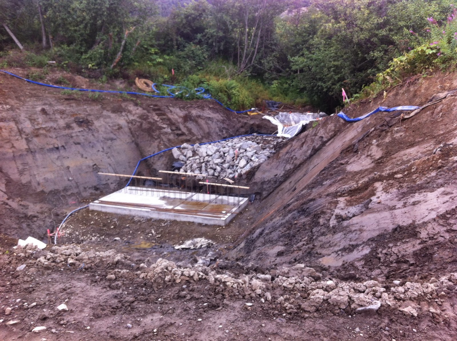
The agony of this summer has been traffic delays nearly every time we drive into or from town. Road construction from about mile 3.5 to 5.0 on East End Road as they redo ditches, replace all culverts, move power lines and build a bike path has us scratching our heads daily. They dig out the dirt, then fill it in, push the dirt around, dig it out and then fill it in again. There seems to be no rhyme or reason to all this dirt moving. 

Large concrete forms have been built for culverts to handle large amounts of water coming down from the bluff

Just a typical construction view...recent rain has probably been slowing things down

Ravines along this section of East End Road are deeper than one realizes
A 3 foot deep, 1 foot wide square-cut ditch runs the entire length of the project, with plastic drainpipes sticking up out of it at regular intervals. Tybar, the heavy duty black tarp-like stuff they put down under the roads is rolled out, waiting for fill to cover it up and the road to finally be widened. It took nearly 2 months just to move all the telephone and electric lines on the bay side of the road to the bluff side and take down the poles.

Each of my two to three trips to town each day are punctuated by 10-20+ minute waits, unless I am lucky enough to catch the line just as it is beginning to head through the construction area. The flaggers are as familiar as family, and yesterday I had the misfortune to turn off my car while waiting and when the line began to move I discovered it wouldn't start so a flagger had me put the vehicle in neutral and pushed me to the nearest intersection. I now plan my waiting-in-the-car activities: read my email, open the mail, check Facebook or make phone calls. On the good side my kids know better than to ask me to run them to town, because a "run" to town means an hour round trip. We try to go before 8 a.m. or after 8 p.m. when the road is open without delays.

While waiting in traffic one day recently Denver was asking me about the road project and I suggested he get online and look it up. Apparently this is a 6.5 million dollar project, with 90% of it being paid for by the federal government. The bike path portion of it is $800,000, so it seems like that part is being paid for by more local (state or borough) monies. It is a 2-year project, which staggers me that we'll have to deal with this next year too. For what?  One and a half miles of gorgeous road and more bike path? The road wasn't great, but I didn't think it was that bad either! And of course we are just hoping the road is paved before winter. We have had more issues with car repairs this summer than all the other years we've lived here, many of them bump-related repairs, which seems like more than coincidence.

What really strikes me each time I drive through the construction zone is how little I know about road-building. I can't even venture a guess for some of the things that they are doing. On one hand it gives me more respect for a career where folks can figure out things like this and run heavy machinery like pros; on the other hand I wonder if they even know what they are doing and if our taxpayer dollars are being drained by projects like this. I just don't know, and I am really, really curious to see if the road and ditches they create actually can handle the insane water and ice issues that develop in this area in the winter. Time will tell. Come to think of it, I should have written this blog post while waiting in traffic.

Sunday, August 10, 2014

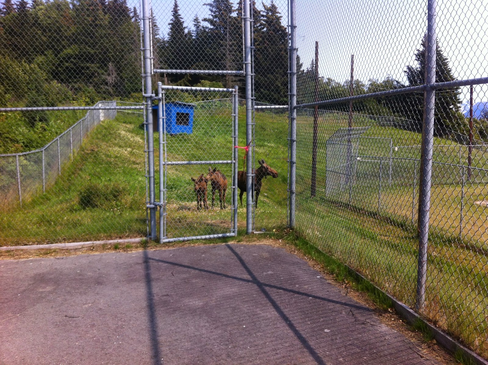
Moose Hanging Out...at the Tennis Courts


The little ones are curious about what we're doing

We've been playing tennis just about every sunny day that we're in Homer this summer, which has been three to four days a week--quite a treat! The 4 courts at the high school court are pavement, but smooth while the 2 courts at the Kachemak Community Center are the hard tennis surface but bumpy so balls bounce funny and water pools. So we usually opt to play at the high school.

Moose hang out on the trails and in brush behind the high school and we see them regularly, since they are just outside the fence as we are playing. The other day we were still surprised to see a momma moose and two babies come up to the fence while we were playing and just hang out for 5 or 10 minutes. Momma would get startled when we would hit the ball with a particularly hard thwunk, but the young 'uns just went about their business, lippity, lippity.

Monday, August 4, 2014

Lucky Strike and Hirshey Mines in Hope

We're back to the mines again. After getting partway up to the mines last summer on our trek out here, we had a rainy day in Hope that made climbing Hope Point out of the picture. You can check out my blog post about visiting this area last year, July 2013. This time was much more interesting and exciting, though.


The road to the Couer d'Alene Campground  wasn't as wide as I recall but it was still close to washboard free, impressive for a gravel road. The view was still awesome with a deeply remote feeling to it. Past the campground up to the end of the road has been improved (looks like recently--this summer) so I could go 25 mph instead of creeping at 10 or 15 mph over giant potholes. The last mile is still rough but nothing a sedan can't make it through.

Palmer Creek as it gushes downstream

View of the valley on a rainy day from a spot almost to the first mine
As before we hiked up the trail towards the mines, which are not visible when you first start out, crossed Palmer Creek, climbed up over a ridge and then we could see the mine tailings spreading down the mountainside. That was our goal.

This is the jumble of rocks that met us at the end of the trail, just above the mining tailings. Disappointment!
Going at a steady pace it only took us 30 minutes from where we parked to reach the first mine. It was just a jumble of rocks, so I figured it was plugged up. The road-like trail ended, but this time I noticed a trail climbing up above to the right of the mine, so we pressed on. It seemed not 50 yards further we came to another mine, this one still open. We didn't have a flashlight, and it looked like sections had caved in, but it was neat to see the wooden structures still present. There was a pile of snow just inside the entrance as well.

The trail past the first mine turns into a minimal path along the side of the mountain

We were startled to discover a second mine along that path

The mine doesn't look very deep (40 feet or so--as far as we could see without flashlights), but old wooden structures are still evident

After checking out the mine I noticed (again!) a trail that continued upward, this one even more faint than the last. We pressed on. I was determined to get to the top of this mountain rather than go all the way down to the stream crossing and follow the trail up along the waterfall. Well, it was a little hairy. 

A messy, wet near-vertical scramble up the mountain sans trail above the second mine

The trail soon petered out and there was loose talus that we slipped and slid on. The climb was pretty darn close to vertical. Each time we grabbed a rock to pull ourselves up on, it would come loose. So I am totally not recommending that route up. It wasn't far--15 or so minutes from the second mine until we reached the top.

Ah, but it was worth it! The view from the top was amazing! If we'd stopped on our scramble we'd have seen it too, but to me it was more beautiful for being on flatter solid ground.

View from on top--comfortable walking with view of craggy mountain peaks
The top was wide and relatively easy walking on moss and rock-covered ground. The ridge-top stretched off to both sides of us. Below us we spotted a cairn on the back side of the mountain we'd just climbed so we headed for that, expecting to find a trail. There was no trail, but from that cairn we found another and another, angling us back up the mountain. Eventually we looked into a higher bowl and saw the remnants of a dying glacier. When we got back Homer Denver pulled up the area on Google Earth and the photo from 2010 showed a glacier substantially larger than the bit that was left. Once again, we are saddened by the disappearing glaciers.

Only 4 years ago there would have been a lot more glacier to view
Then we followed the cairns back down to the two beautiful lakes that are tucked in the mountains and which feed Palmer Creek. 

A beautiful alpine lake

Amazing plethora of crowberries

Palmer Creek waterfall

The trail down by the waterfall
After crossing at the mouth of Palmer Creek, we headed down a well-worn path back to the road.

What a gorgeous area! And as we were leaving we saw another trail going up a different mountain and said, "We have to come back. There's another trail to explore!"