Monday, July 27, 2015

Hiking Grace Ridge '15

This is the third time I've hiked Grace Ridge. We are making this one an annual hike, despite the steep price tag of $85/per person (4 of us) on the water taxi. Perhaps it is time to befriend someone with a boat--or buy our own boat!

Mako's continues to be our water taxi of choice. We haven't had any problems with them besides being late on occasion, but that is to be expected with all the factors that play into across-the-bay travel. They also have a variety of different types of boats (landing craft, catamaran, skiff) for the varying conditions and pickup/dropoff types.


Homer Harbor on a calm, calm morning!
We chose our day well:  it dawned amazingly calm and clear. The boat ride over to Grace Ridge South was speedy and smooth. Mako Junior (not his name; the son of the owner) was our captain and he warned us the south end was pretty brushy. That turned out to be an understatement. But first we offloaded, agreed on a meeting spot for lunch with the speedy kids, and took a layer off from the chilly boat ride.


View of Tutka Bay near our dropoff point of Grace Ridge South

Calm waters looking towards the head of Tutka Bay

The ladder offload method
The beginning of Grace Ridge South:  the beach

Blueberries greeted us along the trail as we began the climb. So did one very messy area of downed trees, which ended up being the only downed trees on the trail the whole 7-8 miles. I was appreciative of being an agile and fit person for this obstacle as it involved going over and under a few trees!


Downed trees made a mini obstacle course

As we began to climb out of the temperate rain forest and moss-covered trees, the brush increased. Ripe salmonberries hanging over and along the trail tempted us, and I nabbed all the ones the kids hadn't eaten. The trail alternated between being invisible beneath the overhanging grass and being an absolutely perfect trail with no brush in areas with spruce trees. In the brushy areas there were times I would stop and look, unable to visually see the trail anywhere. Then I would look down and edge my feet along to look for the indentation of the trail on the ground. That made the hike a bit slower than it would have been under clear conditions.


Find the trail--if you can!
The brush was heavy with dew, so our pants and boots were soon soaked. Luckily it was a warm and calm day so it was not cold. We finally got above the tall trees into the shrubbery area (alders and elderberries and stunted spruce), and finally above treeline. But there are a number of false peaks so we would go up, then down, then up another false peak, then down, then up another peak. The climbing mostly continued till we stopped for lunch at a knoll at about the halfway point.


What not to do:  fuzzy pictures from putting my phone (camera) in the waistband of my shorts!
I was very bummed to discover when I got home that nearly all of my pictures from the top of Grace Ridge were fuzzy. I didn't have pockets in my shorts and for quick access to my camera I tucked it into the very sweaty waistband of my shorts. Mistake! Condensation ruined my pictures. I did manage to get one shot that turned out well. I probably held my camera in my hand for a few minutes while walking and the lens cleared off.


I love the sense of drop-off in this picture. The trail down is steep, but not a cliff!
It took us another 2 hours to make our way down to Kayak Beach moving at a good clip. There was a small section that was overgrown with grass, but the majority of it had been trimmed a foot on each side of the trail and the clippings raked off by trail crews, which made it feel like an expressway compared to our route up. 

Of course the kids ran down so they were busy tidepooling when we arrived at Kayak Beach. Curious to see if they'd found anything cool, I headed their way. Denver was waving at me to come, so I figured they must have found something neat. Neat indeed. It was an octopus!


Within minutes the tide had come in and the octopus was no longer visible, but I was impressed that the kids had had sharp eyes and found it. I've seen two octopuses in one summer, after not seeing any  before. What a treat!

A half hour past our pickup time, the Mako's landing craft skimmed into sight. It's a slick thing just walking right onto the boat. As we headed back to Homer I took a picture of Grace Ridge. As Denver exclaimed, it seemed so small! Funny how big it seems when one is going up it! It is 3105 feet so that's nothing to sneeze at for a good day hike.


Grace Ridge as we're heading back to Homer

Sunday, July 26, 2015

Climbing Hope Point


Wildflowers on trail up Hope Point trail

Friday evening while our family was flopped out in the living room after a busy day, Denver consulted his iPod and announced that the weather for Hope on Saturday was sunshine. Both kids looked at me expectantly, and I knew what question was coming:  "Can we climb Hope Point tomorrow?" I mentally took a deep breath and said, "I'm game." 

A few years ago we climbed Hope Point at the end of a 10-day mountain biking and mountain climbing vacation. We were near the top, with the actual top an unknown distance above us, when the clouds rolled in and obliterated our view. We made the executive decision to go down rather than push on to the top since we were tired--exhausted from days of breaking down our bodies. The kids have never forgotten it, and every summer summiting Hope Point comes up as a goal. Each summer we watch the weather on the weekends to see when we might make it happen as we didn't want a repeat of being socked in by clouds, and the trail is way steeper than anything I would want to do when it is slick.

Trailhead for Hope Point and Gull Rock 
So Saturday morning we left Homer at 8 and were on the trail by 11:35. The weather was warm:  I rarely start a hike with shorts and my short-sleeved shirt, but this time I did, and I only put on a long-sleeved shirt for a few minutes near the top when I took a break and was sweaty and the wind was chilling me.

The trailhead is for both Gull Rock, a 5.7 mile one way hike (the most non-descript, boring hike we have done in Alaska), and Hope Point (probably one of the most beautiful hikes we've done in Alaska). Shortly after we crossed the bridge and turned up the hill for the Hope Point trail, we were puzzled. None of us recognized the trail, which was unusual. I have a mind for trails and they tend to be imprinted in my mind. I couldn't figure out why it was completely unfamiliar. 
Trail construction sign:  rolling rocks
Then we came across a sign:  Trail Construction; rolling rocks. What? Rolling rocks? What rocks? We were in the middle of the woods; there were no rocks in sight. Right around there it was clear there was significant work on the trail. Trees were cut, the trail widened, and there were switchbacks that hadn't been there before. It made for some easy hiking. The switchbacks  were at such a gradual grade that I could dash right up them without a rest. We saw where the old trail had been, the part of the trail that kept me off it when it was wet:  steep and straight up the side of a mountain meadow. Now there was a virtual expressway up the mountain, or as Aurora put it, "What is this? An elevator to the top?!" While the kids were extremely vocal about their displeasure with the trail "upgrades," I just felt a bit queasy in my stomach. What was once a remote mountain climb was now a highly accessible trail. The sense was confirmed as we ran into group after group of people, many of them quite old and not your typical Alaskan mountain climbers. While it was nice to be able to dash up the mountain, it was positively overwhelming how many people were up there. What we had loved about that hike and what drew the kids back was how remote it seemed. With 10 other groups up there at the same time we were (busier than any other Alaskan trail I've been on besides Flattop in Anchorage and the Russian River Falls) as well as the trail crew that was putting the finishing touches on two years of work, it was anything but remote.

Lower trail, below treeline

Climbing up higher; substantial cuts for the new trail

Feeling like a highway across the once-remote meadow

Eventually the scars of the trailwork will grow over

A nice touch:  stone steps through one tricky area

The meadow that a few years ago one had to climb straight up

Once we got above treeline the trail improvements stopped and it was the "old trail" and while there were still plenty of folks up there, it felt slightly more remote. The herd of wild goats weren't grazing above the saddle, which wasn't a surprise. The views are still amazing.

The trail heading up with the goal the peak on the right

Turnagain Arm and the view towards Girdwood

More trail up, from the saddle. The last 15 minutes to the top

The view of Anchorage from Hope Point

The view of Hope from Hope Point
So while the beginning of the trail used to be more challenging and steep with the meadow climb, now the second half is more difficult. It took us an hour to get from the trailhead to the top of the meadow, and then another hour to get to the top. That was moving at a pretty steady pace. The top has a marker so that we knew we'd arrived.

We were sharing the top with some other folks. Amazingly there was barely a whiffle of a breeze and it was warm, so for one of the first times ever I sat comfortably in shorts and a short-sleeve shirt on top of a mountain in Alaska. Aurora's new thing is to bring her juggling balls up and juggle at the top of mountains we climb or hikes we go on, so we got the requisite picture of her doing so.


And for those who aren't inclined to make the 3630 foot climb, here is a video of the view, starting with the view to the north and Anchorage. On a clear day Denali would be clearly visible from here.


The spec sheet about the trail seems to have been updated since the trailwork began (it says 6/14, and they have been doing improvements for a couple years).

The trail specs appear to be updated with the new trail

There are plenty of other beautiful mountain views in Alaska. I am not sure why this particular mountain was chosen for such extensive trail renovations. I am so mixed about it. The joy of climbing a mountain is tempered by the fact that it was way easier than climbing any mountain should be. The meadow that was the glorious highlight of the hike is now criss-crossed by switchbacks and piles of dirt from the cuts. Time will soften those scars. I'll get used to the "new" trail and it will keep it accessible to be as I get older and climbing mountains gets more difficult. But I will still treasure the time we hiked it and it was the prototype of  what climbing a mountain in Alaska means to us.

Friday, July 24, 2015

Camping Right Beach


Sunset over Homer from Right Beach

It seems like every year when we go camping at Right Beach we do the same things:  kayak in Halibut Cove, jump off the rocks into the lagoon river, hike to the glacier lake. This year, though, Aurora and Elisa are interning at the Center for Alaskan Coastal Studies, so they help with tidepooling tours. Elisa is from Anchorage and we agreed to host her, so she is living with us for the summer. So when it came time to decide what to do, they clamored for tidepooling at Otter Rock, which is by the CACS Peterson Bay Field Station. It turned out to be a neat expedition.

The kelp covered rocks across this beach is Otter Rock
It was a quick few minute boat ride on smooth waters over to Otter Rock. We offloaded and then began exploring, with Elisa and Aurora being our guides. There were lots of gooey looking anenomes, oodles of starfish (which I now know should be called 'sea stars' as they are technically not fish), and plenty of hermit crabs scuttling about, along with a variety of other sea creatures. Then we hiked over to China Poot Bay, which is where the CACS takes people on tidepooling tours.

 Lagoon off China Poot Bay as the tide begins to come in
 A group was just leaving as we got to the beach. The leader was excited, telling us to check out Octopus Rock as they'd seen two octopus (apparently octopus is correct, not octopi). We made our way over there and sure enough, there were two octopuses squished in by a rock, looking like pink and white flesh. It was my first time seeing octopuses in their natural setting so it was fascinating.

Octopus in China Poot Bay
It was time to move on as the tide was coming in so we made the trek back to the boat. I am always struck by how neat the cliffs by Right Beach are, twisted in strange contortions.

Cliffs by Right Beach

Right Beach a few hours before high tide. By time the high tide hits there will only be a few feet of beach left below the grass.
Much of camping at Right Beach is waiting for the tides. When the tide is out we can walk to the lagoon, which is a fun place for the kids to play with the river with deep holes for jumping into and riding to current downstream. It's simple camping fun, which is what makes camping special.

A nice rapids is created by the outflowing waters

And then there is the hike to Grewingk Glacier. If the timing is right you can hike there and back via the beach, but we usually take the skiff to the Saddle Trail and hike from there, which makes it a short but beautiful hike.

View of the beach from the Saddle Trail trailhead in Halibut Cove

The start of the Saddle Trail

There were lots of boats moored off the Saddle Trailhead the day we hiked to the glacier lake

Trail crews did an amazing job cutting and raking the tall grass and shrubbery from along part of the Saddle Trail, which is being redone starting this summer
  
Almost to the glacier lake; following the cairns

Just a few ice floes on the lake this summer

But when we are not off adventuring, we were hanging out in camp and enjoying the view.

Calm waters at Right Beach, with oyster farm buoys visible in the distance
And then it is time to go...all too soon! All the gear (everything but the kitchen sink!) is loaded back up and kids gathered up and buckled into life preservers. Back to the boat launch in the Homer harbor, trash offloaded, gear divvied up and we head home to showers and the comforts of home, which we appreciate so much more having been without if for a few days!


Thursday, July 23, 2015

Hiking to Grewingk Glacier from Right Beach


The first week of July we often spend camping on Right Beach in Halibut Cove across Kachemak Bay with my aunt and uncle and cousins. This beach has cliffs on each end of it, so once the tide passes a certain point, there's no getting in or out except by swimming or boat. This makes the hike to Grewingk Glacier a matter of coordination, planning around the tides to hike out and be back before the tide reaches "that point",

My niece and I were the only ones at camp and up for the 14-15 mile hike to the glacier the first day at camp. We started bright and early at 8 a.m. to try to be back before the tide got past the cliff outcropping. It dawned a beautiful morning--with a rainbow over Homer! Luckily it wasn't raining where we were.


A rainbow over Homer greeted us the first morning of camping at Right Beach.
Hours later there was still a rainbow visible!
The first mile of the hike is on the loose pebbles and rocks of the beach, which I consider the most challenging part of this trek. After passing Left Beach, there is a stream crossing. Each high tide the lagoon behind the beach fills up; with the coming of each low tide a rushing river forms as the water empties out. After the cliff outcrops of Right Beach, this river is the other major obstacle to making it back to camp. Since it was a few hours into the low tide, the river was only about a foot deep. I had my hiking boots on with neoprene booties, which I hike in when I expect my feet to get wet (nearly always in Alaska!), so I just walked right through the stream. My niece took off her running shoes and socks and waded.


Wading the river formed by the emptying lagoon

Further along the beach,we found the trail in the beachgrass, which made walking faster and easier. The orange triangular T (trailhead) sign was our clue to head into the woods. The trail register greets the hiker first, and right behind it the outhouse. We set a fast clip. My estimation was that we had 6 hours tops to complete the hike and make it back to Right Beach without having to swim or get a boat ride back. While the map shows it as being a 14 mile round-trip hike, the glacier continues to retreat rapidly, so I am guessing it is at least 15 miles now.


The arrows mark our route to the glacier, starting at Right Beach

There was no bear scat the entire trail to the hand tram. The last time I'd done this hike the hand tram had been terribly difficult to operate, and there is no way I would have been able to do this hike if it were still in that condition. However, I'd heard it had been repaired and was easier now, and that was the case, though it was still a workout, especially past the midpoint when we had to pull ourselves up rather than down!


The tram spans the glacier river

After the tram the trail begins a steady climb up about 500 feet up a little knoll. The trail was quite overgrown in areas so it felt like wading through the grass and the pace slowed.
The knoll provides a nice view of the glacier outwash, river and lake

On the way down the knoll to the glacial outwash area, we passed an area with trailwork done, with the trail leveled and grass cleared. A shovel was leaning against a tree, though no person was around. That section was all too short and soon we were wading through grass and brush that towered over our heads again.  Once down to the outwash plain it wasn't as brushy but the trail was rockier and rougher.

The shock of our day was just past the turnoff to Emerald Lake. The sign said 1.4 miles to the glacier. We came around a corner and there, just twenty feet off the trail to the right, was a dead black bear, splayed out like you see them for bear rugs. It looked to be a two-year-old, and the flies were swarming it. My niece and I stopped in shock and uncertainty. What does one do when they encounter a dead bear?? Are live bears protective of them? It didn't look like anything had been feeding on it, which was a good thing. After snapping a picture and consulting each other, we opted to continue our hike. After that spot there was quite a few small bear scats on the trail for a quarter of a mile or so. As I would find out the next day when I ran into a state park ranger on the Saddle Trail, the black bear had no bullet holes that they could find but its jaw was broken. They moved it far off the trail later that day as someone had reported it.

Dead black bear along the glacier trail

The last 1.4 miles (supposedly) feels really, really long, as it did the last time I did this hike. Finally we got to a knob overlooking the glacier. Looking at  the time, we were a bit behind schedule to get back before the tide came in and cut us off from our camping spot, so we snapped a few pictures, ate a hurried snack, and did not actually go down to the glacier (which my kiddos did the next day when they did this same hike). I've been around enough glaciers it is not a huge ooooooooh and aaaaaaah experience for me anymore. Being on a tight schedule and being  quite tired added to the effect of "been there, done that."

Grewingk Glacier
Now we were really focused on getting back fast, but my legs were tired and it was hard to make them go fast, especially when we couldn't see the trail because of the overhanging grass. One sweet spot in our day was when we returned to the tram. It was on the other side of the river so we had to pull it across before we could get on. A backpacking couple from Europe that we'd passed on the trail arrived just as we were getting on it and they pulled us across so it was a free and fast ride! Sweet!

We started alternating running with hiking to pick up our speed, and the trail got very busy with folks heading up the trail to Grewingk Glacier Lake, a much easier and shorter hike. I had cell phone access so I called my cousin back in camp and asked her how the tide was looking and how much time she thought we had. She guessed we could make it, but it would be close.

Finally we were on the home stretch:  back on the beach. It was so hard to walk fast on those pebbles. My feet were so tired.  Back across the stream, this time closer to the lagoon as the tide was coming in and the spot that we'd crossed at 8 in the morning was now under 5-8 feet of water.

Final stream crossing near the end of our hike
Where we'd crossed the stream earlier in the morning was now under a lot of water as the tide came in
We weren't home free yet. We had to cross Left Beach, which is only a few hundred yards long, but we could see that the water was right up to the base of the cliff outcropping. We made it across as a wave went out and there was a moment when we could still walk across without getting our feet wet. We were literally minutes away from having to wade to get back to camp. It was two hours and twenty-two minutes before high tide. The hike had taken us 5 1/2 hours. I was so happy to be back! 

The next day when my kids did the hike they knew they wouldn't make it back in time since they left at 1:00 p.m. as the tide was already coming in. That is why in the video it shows them being picked up by boat on the beach by the trailhead.

It was a good day and I felt like I earned my s'more that evening as we sat around the campfire!

Wednesday, July 22, 2015

A Hiking Trip Video--Grewingk Glacier

All right, folks, congratulate me--I'm blogging two days in a row! This one is compliments of my son.  Here's the video he created after doing the hike from Right Beach to Grewingk Glacier (the glacier, not just the lake, which is the most popular hike in Kachemak Bay State Park). I'll blog separately about my hiking the same trail the day before he did, which might help explain some of what you see in the video.


Tuesday, July 21, 2015

How Does My Garden Grow?

Some folks may have wondered if I was ever going to blog again. I admit the thought crossed my mind as well. Insanely busy spring turned into even more insanely busy summer and now that I've gotten lots of yard/house improvements behind me, and a bunch of adventures under my belt, I think I may have found a breather to sneak in writing a few blog posts of some of those summer adventures.

But first, on the home front, is the garden. I've been harvesting lettuce, kale, spinach, parsley and basil for a month already, but now the cucumbers, tomatoes, kohlrabi and zucchini are coming it and it begins to feel like abundance.
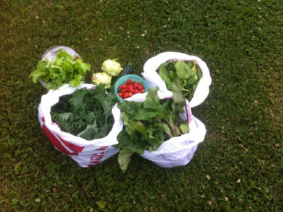
Today's harvest:  bibb lettuce, curly-leafed kale, beet greens, spinach, strawberries, kohlrabi, cucumber and zucchini
This year I planted my own starts for all but tomatoes and zucchini (only because I didn't have the seeds on hand when I was planting starts!). I keep my seeds in the freezer and discovered that they dated back to 2009, the last time I'd done starts. I wanted to see if they would grow. But as often happens, I planted waaaay too much, because everything except the turnips grew, and grew well! So rather than my usual 3 cucumber plants I have 15!

I ran out of space in my garden for the cole plants: broccoli, cabbage, kohlrabi and cauliflower so I threw them into any spare space in my greenhouse. Of course, spare space when I planted them is much different than now, so the gigantic zucchini plants are crowding out the poor broccoli plants. Don't know if that was an unwise move or not. I was going to transplant them outside if some of the outdoor plants died, but only one did so they didn't get transplanted.

After two mild winters and unusually warm summers, I'm not sure what normal is anymore, but it sure seems like everything is early. Funny how I can gladly adjust my expectations.  This warm summer has brought little rain, and I know it would be doing better if I watered it. Delivered water is now up to 6.5 cents per gallon so to maximize the profit of growing my own veggies I try to minimize watering. Even after we got 2 or 3 days of solid rain the other week, it was still dry under the surface. I keep an eye on the forecast and will it to rain, though for other reasons I sometimes will it not to rain!
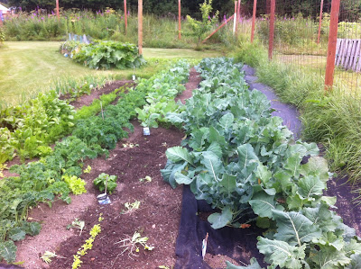
July 21 garden view
This year I planted fewer potatoes and way more cole plants and lots of kale. In any spot in the garden that seeds did not come up I've been tossing in more lettuce or spinach seeds for a late crop. We had some landscaping cloth leftover from past years' projects and on a whim I decided to utilize it to keep down weed in and beside the garden. It works like a charm; I don't know why I didn't do this years ago. It reduces my weeding time significantly, and it keeps down the weeds next to the garden in an area we can't get to with the mower. It also provides a buffer that the slugs would have to cross to get to the plants if slugs were an issue, which they are not since it is so hot and dry.

I planted a few different crops this year:  I had celery seed left over from years ago and threw it in; it is doing great in the greenhouse. It was a dud in the garden. I finished off the rutabaga and turnip seeds. As I mentioned the turnips didn't come up but the rutabaga are going nuts so I'll be making pasties again this fall, which is the only dish I use them in. I might have to expand my repertoire of rutabaga recipes this year.

As always, the compost lines are obvious in my garden, clearly delineating between soil that has been supplemented with good stuff and the natural soil. Both my rows of beets and carrots show this, giving me the heads up of where to plant my compost next spring. The store-bought fertilizers just don't do as much for my garden as fish gurry and compost, so if I want beautiful plants, I need to do the work to make my own fertilizer. I'm getting my routines down, though, so it goes more smoothly and easily.

The strawberries must love this warm weather. The plants are well over a foot tall and producing fairly well. I just put chicken and rabbit wire over them but the birds still manage to get in and munch the berries so I think I need to invest in some bird netting. I hung some old CDs around off the wire, thinking the movement and shininess might discourage the birds from hanging out with the strawberries so much, but when it is calm they don't move at all so I'm not sure they're helping much.

All in all, I'm pleased with the garden this year. Especially pleasing is the lack of weeds. I've had 2 light weedings of the entire garden since I planted it the end of May--once in mid-June and once in mid-July. A light weeding means the weeds were easy to pull and it took less than 2 hours to weed the whole garden. I don't know if it's because my soil has more nutrients in it now, or if it's just too dry for weeds to grow. Either way, I'll take it!