Sunday, August 12, 2012

Primrose and Lost Lake Trails

Lost Lake was so calm the days we were there it was difficult to tell reflections from the real thing!

Note:  I lost my camera, it was found and an awesome person mailed it back to me so now I have pictures to add to this entry!

In a year of my son being a member of our local Boy Scout Troop 555, I have only made it on one of his campouts, despite wanting to go on many more (made it to Swan Lakes a year ago June).  Originally the Lost Lakes hike was going to be last weekend, which I would not have been able to make, so when it was switched to Aug. 10-12, I was ecstatic!  This is one of the few "big" point-to-point trails I have not hiked on the Kenai Peninsula.  It turned out to be the best weather of the entire summer I think--just amazing--so we really lucked out.

A backpacking trip starts with packing, and I'd been at retreats the past 2 weeks so hardly had gotten any exercise, so I was being deadly with cutting weight.  Even my toothbrush didn't pass muster!  When I weighed in at 35 pounds, pre-food, I was feeling pretty good.  We ended up having 5 scouts and 4 adults going, which is actually a good ratio.  The adults can carry more than the kids so they loaded up with heavier items like stoves, fuel, filters, food, etc.  I'd done the food shopping for this trip at Costco so we had lots of food.  More on that later.
The Primrose Trailhead!

Originally we were going to do an out-and-back hike, up the Lost Lake side 6 miles, then back out the same way.  With a smaller and more capable group, our scoutmaster decided to have us do a point-to-point:  up the Primrose Trail 7.5 miles on a Friday, then 7.5 miles back down the Lost Lake side on Sunday, for a total of 15 miles with a day off in between.

After the woodchips, hard, packed dirt made for great hiking.

  
We left Homer at 8 a.m., and didn't get on the trail till 1:00.  We stopped for bathroom breaks, made our way through the construction zone on the Seward Highway, got a vehicle parked at the Lost Lake end, and divvied up food and loaded packs.  Probably the most humorous part of the weekend was the food:  since I'd done a Costco run, everything was in bulk.  I just handed all the food out of my vehicle to be put in a pile, expecting people to break down amounts and leave some in the car.  By time I got over there all that was left was a bag of bagels, so that was all I had to carry.  When we got to camp and started unloading the food, I laughed so hard!  We had 12 pounds of summer sausage, 2 large ziplocks full of rice, 6 large cans of canned chicken and even a large glass jar full of strawberry preserves (which was for peanut butter and jelly sandwiches at the car after the hike!).  We ended up eating nearly 9 pounds of the sausage--which was a real hit actually because it was substantial and easy.  The 36 string cheeses all got eaten too, for the same reason.

This was a surprisingly large waterfall!

The trail was nice--started out woodchips, then hard-packed, smooth earth, with gradual uphills.  After a couple hours it got steeper, just before we broke out of the trees onto the ridge.  When I asked Denver to describe the trail he replied, "It's a trail."  Embarrassingly, that was my description too.  The Primrose side is rated moderate, and is 7.5 miles to the large bridge which is the halfway point.  It's just a nice, pretty trail--it gets you there.  At mile 2.5 there is a very large waterfall about 200 yards off the trail (you can hear it as you walk by).  The highlight is when you break out of the trees up high and you get the view of mountainous mountains--spikey, rugged, jagged, snowy peaks all around.  On the ridge that you follow, there are dozens and dozens of alpine ponds (Denver's term--perfect description!)--pools from a few feet across to a few hundred yards across. They are amazingly picturesque. And then you see peeks of "the lake".  It looks like a big one, but you just see a little here and a little there.  That would be Lost Lake, which we didn't see in its entirety until our hike up a ridge above it the next day.

Primrose Trail, just out of the trees, with Kenai Lake in the background.
There are 2 established campgrounds before the 7.5 mile halfway mark.  Everything looks quite new:  a crew of 6 or 8 hardy young adults were hard at work improving the trail and campsites, closing old sites for revegetation purposes and cutting drainage ditches.  This group had a campsite across the river from us where they all rendezvoused each evening for dinner before scattering to their tents, which were in different locations.
Lost Lake is ringed by mountains and hills--an idyllic setting in nice weather!

A 15-20 foot wide river runs from Lost Lake into a lower lake.  We camped by that lower lake.  The bear container was recently installed by the looks of the fresh sod and the outdoorsy outhouse (no walls) was also new.  The bugs were bad, and as we discovered when the leaders created a fishing pole from a tree branch, line in their emergency kit, fishhook they found and cheese from our bountiful supply, the fishing was very good as well (8-12+ inch trout).

This picture has it all:  alpine pool, mountains, snow, flowers, rocks. 
This is your typical view on the middle section of this hike-Primrose/Lost Lake.


Friday night I caught my breath in awe when I stepped out of the tent for a bathroom run.  The moon was out and....stars!  For the first time since May I saw stars!  Only the largest constellations were visible as the night still wasn't deeply dark, but it was thrilling!  The mountains rose up in snowy majesty in the distance.  For my second bathroom run about 6 a.m. I got a second shock:  frost!  The dew on the tent had frozen into ice, and the grass was frost-covered.  It froze both nights I was there.  What a short summer! 

View from the toilet!
Open air toilet!  Guess we should be glad we had that!


Saturday dawned warm and sunny, a miracle in my book, though I know days like this do on occasion happen.  We had no plan:  it was a day of freedom.  Four of us decided to go for a hike.  We continued up the trail and then headed up the ridge rising above the far side of Lost Lake.  The lake was so glassy and smooth you could hardly tell what was reflection and what was real.  Gigantic, fat marmots peered at us as we stepped through their territory.  From the top of the ridge, I counted 12 glaciers on the mountains across from us--an expansive sweep of peak after snow-covered peak.  It was a blessing to just sit and gaze in wonder over the expanse of hills, mountains and lakes since it is normally too chilly to want to sit around or, like at camp, too buggy.

This was my favorite lookout spot for watching the bikers, runners and hikers go by.
It was a nice, sunny, warm nook!

One of the most interesting parts of Saturday was finding a cozy, sunny knoll on the bluff above the river with a view of the trail.  An amazing amount of traffic went by!  I saw groups of bikers, runners, day hikers and backpackers.  I was amazed at how late in the day people were going by (7:30 p.m.).  It was fascinating seeing conditioning level of athletes.  Some runners would walk up the stairs, while others dashed up with no hesitation.  In a couple weekends there is the Lost Lake Run, a fundraiser that hundreds of people show up for and run the 15 miles that we hiked.  So I suspect the beautiful weather and weekend drew out lots for training runs.  If I want to quiet backcountry experience, this is NOT the trail I will hike--or I'll hike it in September!

Alpine tundra at the top.  Resurrection Bay in the distance, and Seward straight ahead,
though down 1900 feet 9 miles or so.

Sunday too dawned clear and calm.  We started breaking camp at 8 am and by 9:15 were on the trail.  The pace was steady.  We thought we were at the top but there was still a ways to climb before we reached the highest point on the trail.  Then we finally began to descend.  At that point Resurrection Bay opened up ahead of us, and we could see Seward in the distance. 
This was about 1 1/2 hours from the 7.5 mile mark--about halfway down the Lost Lake side.
Vegetation is larger here, though not rain forest mossy yet.

Descents are always interesting as you go through one climate after another.  We were in alpine tundra when we started, with plants only a few inches tall at the most and very dry.  Then the plants began to be taller and more succulent, and there was a profusion of blooms across the meadows.  Below that, maybe an hour and a half from the top, the plants were well over our heads--ferns, devil's club, pushki--and I was very grateful that they'd trimmed the brush a foot out on both sides of the trail.  The trimming made the difference between this being a very nice hike or a miserable hike.  Impressively, even at the lower elevations, the pushki had not even flowered or bloomed yet (it has been done for weeks on the rest of the peninsula), there were no berries on the devil's club and the ferns were still unfurling.  This area got hit extremely hard with snow this past winter, so I suspect the trail has not been open as long as usual.  We only came across snow right on the trail at mile7.5, though there were patches off to the side here and there over about 1300 feet.  And finally we reached the rain forest, with everything covered with moss, and large hunks of moss hanging from the trees.

Of the people who have hiked this trail, they have stories of it being wet, rainy and cold.  I was prepared for that, but am very grateful that we had a glorious weekend of sunshine and warmth.  There were only 3 bear scats the entire trail, on the Primrose side, old, and down near the trailhead, so we didn't get a strong sense of bear presence along here (the traffic could be a contributing factor!).  On the Lost Lake trail side, there is a cabin that can be reserved.  It is down a separate loop trail, so there are actually 2 routes that can be taken. 

With only a 1500 foot elevation gain, this is a fairly easy longer hike.  For biking there are some sections that are steep or rocky and would be challenging, but much larger sections that would be wonderful biking.  I think I would have to psych myself up for dealing with crowds if I do this again, though perhaps the combination of weather and weekend brought people out in droves.  The views are absolutely incredible and worth coming back for--just choose a clear day!

Thank you, Lynn of Anchorage, for sending my camera back to me!

Friday, August 3, 2012

Calvin and Coyle Trail

Bridges over the streams on the Calvin & Coyle Trail are an appreciated addition.
Five years ago when we moved to Homer we checked out the Calvin and Coyle Trail, just over 1 mile out East End Road from the 4-way stop intersection.  It was boggy and grassy and unmarked, we had to park along the road, and it was so unworthy of any mention that I didn't blog about it.  I wouldn't have wanted anyone to check it out.  In the 5 years since then it has been improved greatly, and it is now a trail worth mentioning!

A new kiosk and parking area improve access to the Calvin & Coyle Trail.
Now there is a parking area and trailhead kiosk with a map and explanations about the area.  It is owned by the Kachemak Heritage Land Trust, so they are the ones who do the improvements.  In 2009 a local Boy Scout built bridges over some of the streams as part of his Eagle Scout project.  And last year Troop 555 (including my son) added 8-10 interpretive signs.  Now about 80% of the trail is boardwalk.  It is a boggy area, so those boardwalks are sorely needed. 

The viewing platform overlooks the bogs east of Beluga Lake

Boy Scouts put in the interpretive signs last fall. 
They were later vandalized but then restored.
The trail goes out, splits into a loop that heads out to an observation platform that overlooks the swampland at the head of Beluga Lake, then loops back around to the main trail.  We estimated it is about a mile total.  Yesterday when Denver and I did it, the trail was weedwhacked so we weren't wading through the tall grass.  There were several benches along the way.  I wasn't able to appreciate the scenery too much because Denver set a blistering pace, and I took the pictures as I walked.  Now that I know that it has been redone, I will visit this trail more often, particularly when it is really windy since the trail is sheltered in the trees and would be more protected than the beach or spit.  Next time I'll take it a little slower, though!

Much of the trail is boardwalk now, but some sections are hardpacked earth.

Wednesday, August 1, 2012

Stillpoint Lodge, Halibut Cove


View from Point of View cabin, Stillpoint Lodge, Halibut Cove

 Early in the spring I signed up for a retreat at Stillpoint Lodge in Halibut Cove.    I don't think I realized what a treat I had signed myself up for.  A few months later I looked on Stillpoint's website, and I was expecting rustic, basic cabins.  Instead, it looked luxurious and beautiful.  In reality, it was somewhere between the two.  It is quite an amazing place, though, so here's a brief on the place and the experience.

The travels begin at the Halibut Cove check-in office on the Homer Spit.  From there I made my way to Pier One and the Danny J, a wooden J boat from World War II that now functions as the main ferry from Homer to Halibut Cove.  The boat was full the day I headed over, last Thursday.  Most people would be heading over just for a few hours, to eat at The Saltry, wander the boardwalks and peruse the art galleries.  Part of the ride included a swing by Gull Island to check out the gulls, puffins, cormorants and other seabirds that might be hanging out.  We saw a few sea otters as well.

Eating at The Saltry, Halibut Cove's one restaurant, was next on the agenda.  All of the retreat participants sat together at one table (7 of us), plus the 2 nuns who were facilitating our retreat (Marguerite Buchanan & Suzanne Toolan), plus Stillpoint's owner, Jan Thurston.  It was sunny and warm so we sat outside, enjoying great service, excellent food and each other's company.  Some of the retreatants had been there before, while for others it was their first time.

After lunch, we wandered down the boardwalk and up a trail to the Halibut Cove cemetery, and a view of the arch.  The gazebo is the final resting place for Diana Tillion, who passed away a couple years ago.  She and her family were (still are) huge influences on life in Halibut Cove.

At 4:00 we arrived at the mail dock (the post office is on a dock) to catch a quick ride across the cove from the island (which we were on) to the mainland (which Stillpoint is on).  The adventure was just beginning!

The dock at Stillpoint
Stillpoint appeared to have 3 boats and 6 kayaks, which makes sense as there is less driving on roads than there is driving around the cove dropping off and picking up people, mail and freight.

Main lodge, view from entryway, Stillpoint
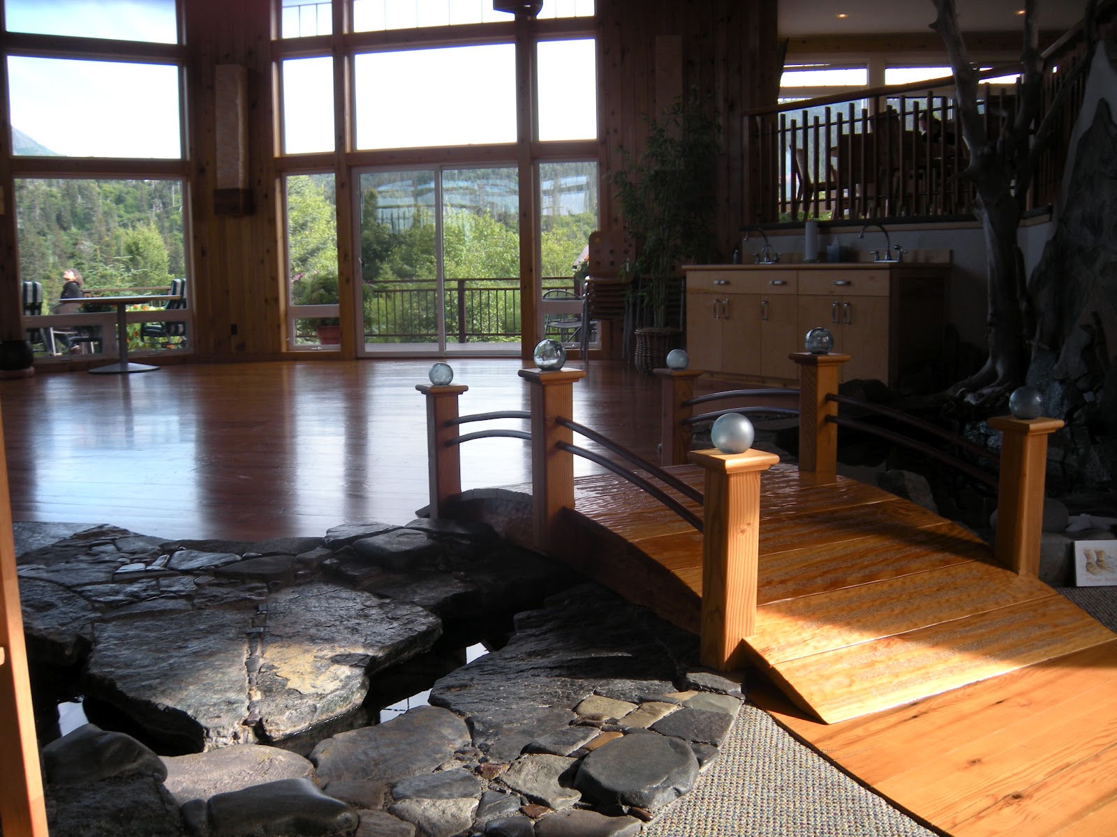
We headed up to the main lodge, which is an amazing place.  The first sight to greet you when you walk in the door is a stream meandering by with a bridge over it and the activity/yoga room.  The floor of the activity room are from the deck of a ship--practicing the recycling philosophy that is central to Stillpoint.  No shoes are to be worn indoors so a room with cubbies is by the entrance, offering booties for those who want warm feet.

Lounge in main lodge at Stillpoint
We headed up some stairs to the left to the lounge, a comfortable area with a fireplace, sound system, overhead projector and stunning view of Halibut Cove.  Across from the lounge area was the dining room and kitchen.

After a brief primer on how things would go at the retreat, each person was turned over to a staff person who would take us to our cabins.  Our luggage had been stowed on the Danny J in Homer and transported to our cabins already.

View of dining room from lounge in main lodge
There are 11 cabins plus the Heritage (for private or individual retreats).  Some cabins are 'doubles,' right next to another cabin, while 3 of the cabins are by themselves.  All of them have composting toilets, and the only water in them is urns with spigots that run into sinks.  All of them have different views as Stillpoint is on a peninsula.  Some are lower and closer to the water while others are higher up.  The water comes right under some at high tide, while others are a bit off the water.  I was assigned to Point of View, which has one of the best views of all the cabins.  Black bear are often seen from the deck.  And as you can see from the picture at the top of this blog entry, the view was idyllic first thing in the morning on a calm, sunny day--truly a 'still point'.

Point of View cabin
When Stillpoint first opened in 2004, the first retreat was for quilters, and payment for coming was to bring a finished quilt to go in the room.  Carpet swatches and color schemes were given so all the cabins are decked out with homemade quilts.

I received instruction on how to use the composting toilet, how to use the blinds, and then was left to freshen up, unpack and get my bearings.

Inside of Point of View
The rooms were very comfortable.
 I wandered around on the trails, checking things out.  I found the garden especially fascinating as it has landscaping carpet put down with wood chips over it and holes just for the plants.  They switch what gets planted where each year but the overall format is the same every year.  They also have a couple of greenhouses and container gardens all over the place.  Much of the food served is grown right at Stillpoint and harvested within hours of mealtime.  Vegan food choices were standard, though some seafood was served as well.  Which leads to dinner....

Dinners were beautiful, and fed the spirit as well as the body.

Meals were amazing affairs.   Breakfast and lunch were served buffet style and were taken in silence, respecting peace and reflection of the retreat setting.  Dinner, however, was set beautifully each day, with fresh flowers, linens and different dishes each day and it was a relief to chat and get to know fellow retreatants.  I found myself wanting to take a picture of the table setting every day, an urge I have never once in my life had.  I tend not to overeat, but the food was so beautiful and so tasty I just wanted to keep eating!  It was satisfying and filling, despite no meat (just small amounts of seafood).  The food was probably one of the most inspiring parts of my experience at Stillpoint as I discovered the joy of fresh, organic ingredients, tasteful presentation and a slower pace of eating.

 The atmosphere and food aside, the retreat itself was a treat.  There were 7 ladies there, all from Anchorage except for me.  The retreat was called "The Heart of Compassion," which is kind of a amorphous title.  One lady, who has come to retreats here every year since it opened, said, "I would come to this retreat even if the topic was moose hunting!  Marguerite and Suzanne are wonderful!"  The two nuns from San Francisco, come up every year to run retreats, changing the topic each year.  They are sweet, but also very real, endearing and not above teasing, qualities I respect in their advanced age (they're both in their 80's).  They guided the retreat with a grace that allowed us each to reflect and go inside, but also to express ourselves.  It was a nurturing balance.

The only time we could talk was during sessions when we would share our inner thoughts and growth, and dinner.  There were 3 sessions a day, punctuated by meals.  It set up an atmosphere of being there for that growth rather than just a social chit-chat thing.  The day would begin with optional yoga and then meditation, both which were rejuvenating, and the instructors, Lucas and Gita, were wonderful!  After the morning session and lunch we had 4 hours of free time to kayak, hike, get a massage, spiritual direction, nap or whatever.  I did all of those except the nap, and each were fulfilling and special in their own way, adding to experience.

This year there are 10 retreats and workshops being offered at Stillpoint, with topics ranging from painting and journalling to living a meaningful life and spirituality.  The mission of Stillpoint is to develop deeper spiritual connection and creativity.  Throughout the summer one can go there on their own to the Hermitage (which has its own kitchenette) for a private get-away, yet still take advantage of the kayaking, hiking, spiritual direction, sauna, library, labyrinth, and more.
 
 Part of what I appreciated about this retreat was getting to know the people and place of Halibut Cove.  It is a very isolated community, only 10 miles across Kachemak Bay from Homer, with 120 people in the summer and only 25-30 in the winter.  It is part of the history of Homer and so I loved getting the sense of the place by being there, talking to people and watching the traffic in the cove: boating, sculling, paddleboarding and kayaking.
Main lodge, main entrance at Stillpoint

We were blessed with glorious weather for the three days we were there--warm enough to wear shorts even one day--and that probably helped make this a special time, but it was an amazing retreat and I so recommend it to anyone who might get the chance to go there!

See http://www.stillpointlodge.com/ for other pictures, the retreat schedule and more information.

Monday, July 2, 2012

Summing it Up--Our Biking Vacation

Six months ago I would not have even conceived of this biking trip.  A year ago I would have said, "No way, I can't bike those trails!"  And even more so, I wouldn't have thought the kids could do it--or would even want to. What happened to take us from "No way" to "Yes!  Let's do a 10-day Alaska biking trip!"

The kids are both teenagers now.  During each stage of their development we've had to reinvent our family, so to speak.  We have to tweak our vacations to fit their need for adventure, level of fitness, interests and needs.  At the same time we have to balance it with Douglas and I, our needs (yes! for adventure!), time, budget, level of fitness and interests.  We've been on the Alaska Highway 5 times in 5 years of being in Alaska.  Been there, done that, and though it could be explored more fully, it is a long haul and gas is stunningly expensive along it.  So in contemplating an Alaska trip, I tried to think of something that would 'grab' the kids.  Aurora pooh-poohed mountain biking, said it was too easy and suggested we do the entire 38 miles of the Resurrection Pass in one day.  A few days into our vacation she ate her words, and she realized that she loves to mountain bike.  It is challenging, a bit dangerous, provides an awesome adrenaline and endorphin rush, and she gets dirty!

It has been over a week since we've been back home and I am itching to get out and bike again.  But what did I learn from all this?  What were my observations?  Here are some thoughts:

All geared up and ready to go for our first ride on the Russian Lakes Trail
Gear:  The amount of gear needed seems intimidating:  bikes, helmets, biking gloves and shorts, hydration packs.  In our case, multiply by 4.  And then add accessories for the bikes.  Douglas and I were still wearing our helmets from high school (want to guess how old those are??!!), but our biking shorts had long since disintegrated so we had some investments to make before we could go on this vacation.  I wouldn't do it without padded biking shorts--that made all the difference in comfort.  And we just wore our junkiest shoes because they ended up getting completely muddy.   An odometer is an investment I highly recommend.  It was very helpful to know how far we'd biked, and the new odometers have miles per hour in addition to mileage.  What we have discovered recently in looking at bikes is that Douglas and I are on bikes that are waaaaaay to big for us.  Doug rides a 23" (meant for people about 6'4"), and I ride a 21".  We should be on 19" bikes probably.  So we were hauling around a lot of extra bike and lost a degree of maneuverability in the process.
 
Gear check:  Wheels get rattled loose, junk gets caught in the gears, mud clogs up the brakes.  Every so often when we were on the trail we'd call out "Gear check!" and we would all check our wheels for tightness and basically look over things to make sure all was well.  This is so important, and I'm glad we did it as about every third time we checked there was something that needed adjusting.  My only next time for this is that we know how to repair bike problems a little better.  We had some problems that we had to work through on the trail that bike repair/maintenance tips would have helped.


Food:  We were expending huge amounts of energy during our bikes and hikes.  Having substantial lunches plus snacks was an essential part of enjoying ourselves.  Though I kind of felt like bear bait, we generally had some sort of high protein lunch:  ham or tuna sandwiches or sausage and cheese.  It has to be food you want to eat.  The last day when we climbed Hope Point all we had was dry stuff:  chips and crackers and granola bars.  They weren't appetizing so the kids didn't eat much.  That affected the quality of the hike.  When out there I was so aware of food as fuel.  In our sedentary culture we often lose sight of the connection between food and what it is really doing, beyond comfort and satisfaction:  fueling our bodies.  When exercising hard for 3-5 hours a day I became so aware of my dependence on my fuel and the ability of that food to actually "fuel" me.

Water:  Hydration packs are the best!  Denver has a 3 liter pack and I have a 2 liter pack.  Douglas and Aurora have water bottle holders on their bikes.  Everyone had to have their own water.  As the week wore on and the weather got warmer (ooooh-60 degrees!), we took more and more water each day.  Normally when we hike mountains we have a bunch of waterbottles and we shove them in the backpack and they are so clunky.  Having the hydration packs allowed us to take a lot of water plus food and extra clothes.  We also had one backpack that we dedicated to rain gear, an emergency kit and bike repair items.

Bear:  In a week of biking, we really didn't see a lot of fresh bear scat.  The Russian Lakes Trail had quite a bit of fresh scat, and that was our first ride when we were still naive newbies.  Our bikes make noise, but usually we don't talk a lot while biking, so I would whistle when I had enough breath to.  I admit I was particularly nervous when we did the downhills because we were going so fast and going around curves and could easily startle a bear on the trail.  We didn't have a gun or bear spray with us.  Were we dumb?  I don't know.  

Point to point:  We'd taken 2 cars on this trip, hoping to do some point-to-point bike rides, since all the passes are point-to-point.  However, the shortest one would have been 23 miles (Johnson Pass), and our conditioning level wasn't there yet.  So we settled for out-and-back, which was fine too because it was a bit more predictable (when we turned around we knew just what was coming!).  Plus, every trail seemed to be uphill, so when we turned around they were all downhill.  Be a bummer to miss out on the downhill!

Gear, gear, gear!

Will we do this again?  Yes, in a flash!  We all enjoyed it, and it will only get better as Denver gets in better shape and as both the kids develop skill and technique.  Our AK biking adventure was a success!  And I discovered that "Yes, I can do it!"

Thursday, June 28, 2012

Hope Point Climb--Hope, AK

Pink lupine were a special treat.
We were feeling a bit beaten up by all the tough mountain biking we'd done, and we'd biked all the trails we'd set as our goal for this trip, so for our final day we decided to drive up to Hope (about a 40 min. drive from Cooper Landing) and climb Hope Point. 

This was not going to be a cakewalk:  the trail description said there was an elevation gain of 3,630 feet in 2.2 miles.  That would make this our biggest climb yet--ever!  But after all we'd been through the past 8 days (3-5 hours a day of vigorous exercise) we knew we were in as good of shape as we were going to be in.  Plus, it was just a hike!  How hard could a hike be compared to biking it?!

Up through the meadow.  It was a lot worse coming down!
The trailhead, at the end of the road in Hope, just before the Porcupine Campground on the left, was so new there was still a shovel and broom sitting out for cleanup.  The trail starts off graveled and wide.  After crossing a small bridge the trail splits, with Gull Rock trail veering off to the right and Hope Point heading left along a rushing mountain stream.

So, of course, this trail went UP!  And up and up.  What did we expect?  Well, it was steep.  And in the most beautiful section, we broke out of the trees into a glorious mountain meadow covered in a profusion of wildflowers:  lupine, geraniums, and on and on.  Hope was already far away, way down there, and Turnagain Arm was spreading out to our right.  Through this meadow the trail was gravel on top of hard-packed earth, with a pretty darn close to vertical incline.  It was challenging going, and I found myself taking lots of breaks.  Partly, though, the breaks were because the view was so stunning.  Of all the hikes I have been on in Alaska, this one TOPS my list for beautiful.  I'm afraid I have used too many superlatives in the blog entries describing this vacation, and maybe it was a result of large quantities of endorphins flooding my system from all the exercise, but the beauty just stunned me, and my family concurred.

Our route was up that ridge straight ahead, then left along the snow.  We thought we were going to the peak seen here, but it is the one hidden in the clouds.
Spectacular views of Turnagain Arm
Up, up, and up.  We kept looking up, wondering where the trail would lead us.  Once we got high enough we could see the trail traversing the slopes above us, but then we would lose it in the snow or the clouds.  It was all single track, with loose rocks aplenty.  The technique for getting up these climbs is one step at a time.  Breaks and water are good too.  One thing we did right was bring lots of water:  our hydration packs were filled to the max of 2 and 3 liters respectively, and Douglas and Aurora each had waterbottles as well.  By climb's end we'd have drunk nearly all our water.

Above the meadow the trail leveled out as it followed the top of a ridge.  Below us spread out Turnagain Arm.  We could see Anchorage to our left, the Seward Highway wound around the cliffs of the Turnagain, and far to the right was the head of the arm and the start of the Kenai Peninsula.  Of all the hikes we have taken, this was seemed the most remote, which is ironic because we were in sight of the major population center of the state.  Or perhaps because we were in sight of and yet so far away from all that busy-ness.  It was a perspective that really turned things around.

Heading down--back along the spine of the ridge ahead of us.

At one point we were following a snow chute up, hiking alongside the snow.  When we got to the top, Aurora was waiting for us, eagerly pointing out the mountain goats she'd seen.  We watched them for awhile and then pressed on.  We'd thought we were near the top, but the trail, rather than jogging left across the snowdrift to a peak, continued up to the right across the saddle and into the clouds.

We saw up to 14 mountain goats at one time:  sleeping, playing, fighting, grazing.  It was a treat!

By this time we'd been on the trail over 2 hours, climbing steadily up for probably about 3200-3400 feet.  The signs of fatigue were there:  Douglas was not drinking a lot of water, crabbiness, fuzzy-headedness, lack of decision-making.  The kids were rarin' to go and didn't want to stop, but finally I insisted on a food break.  It was our last day of camping and our snack supply was depleted so we didn't have the hearty lunches we'd had other days:  tuna or ham sandwiches, sausage and cheese.  All we had were crackers, carrot sticks, pudding and granola bars.  I had gotten onto the trail hungry that morning, so I was ravenous by this time.  The kids weren't that hungry and were just begging to push on.  Douglas was getting nervous because the clouds were rolling in quite thickly so visibility was cut way down.  We could no longer see the summit or even any false peaks above us, and below us was all clouds with occasional openings through which we could see the mountain goats wandering the snowfields and meadows below us.  Turnagain Arm was out of sight.

View of Anchorage (not much a view with the clouds)
View towards the head of Turnagain Arm.  Hope is in the bottom right corner of this picture.
We hemmed.  We hawed.  Douglas wanted to turn back.  The kids wanted to keep going.  I wanted to keep going but I was also aware of how tired Douglas and I were, how little the kids had eaten, and how far we had to go back down.  We figured we had to be pretty close to the summit, but we'd thought that a few times before and we discovered we weren't even close.  Finally I decided:  "We're heading down."  The kids were so bummed.  I was bummed too, but it felt like the best choice for the circumstances.

Down we went.  Back past the mountain goats, past the snow chute, down out of the clouds, along the ridge, through the meadow, along the stream to the trailhead.  When Douglas and I walked up to the car, the kids looked like zombies.  They were tired.  On a clear day, with better food we might have pressed on, but for that day, it was what it was.  The view was stupendous, the mountain goats were a treat, the workout was beyond words and the sense of remoteness disquieting.  The kids and I made a pact to come back and complete it--all the way to the top.  It was a stunning and awesome grand finale to our vacation.

Up Snug Harbor Road: Cooper, Russian & Rainbow Lakes


 A couple weeks ago Denver and I had driven up Snug Harbor Road in search of the other end of the Russian Lakes Trail.  We were stymied a mile or two short of our destination as the road still had a foot or more of snow on it so we'd been unable to reach the trailhead.  After biking the Resurrection/Bean Trails we were ready for some mellow activity, so we headed up the Snug Harbor Road to explore.

Ten miles up the road (give or take) was the Rainbow Lake Trailhead.  It looked so beautiful and inviting we just had to stop.  We ate a snack and checked out the trail specs:  1/2 mile, 50 feet elevation gain.  We could handle this!  Out of habit we threw on our hydration packs and away we went.  The Rainbow Lake trails is a sweet, fun little hike.  The trail looks to be handicap accessible and is gravel the whole way.  The views of the surrounding mountains were beautiful.  At Rainbow Lake there was a picnic table and we chatted with the fisherman sitting there, a guy from South Carolina with the thickest accent I've ever heard!  Just down the trail 50 feet was another lake in another picturesque spot.  I have tucked these into my file of "picnic spots" that I want to go back to someday.

Rainbow Lake Trailhead, off Snug Harbor Road

Back to the car we continued up the road. A bit further we reached the Russian Lakes Trail--the other end of it.  We'd driven 2 cars on this vacation in the hope of doing a point-to-point bike ride or two.  Unsure as to whether the snow had melted and the road was accessible, we'd not come back up here to see.  The snow was melted (off the road anyways) and we saw a couple of people jogging down the Russian Lakes Trail.  If we'd done this it would be 20 miles from here down to the Russian River Falls Trailhead, more downhill than up from what I hear.  It is on my bucket list!

Cooper Lake
A mile further along, at the end of the road, was Cooper Lake.  We got out to explore, only to be greeted by some vicious dogs that seemed ready to attack us.  We backtracked hastily and found another spot to check out.  This lake is at a fairly high elevation.  It is dammed up, and I suspect that the beautiful gravel road we'd driven up was built for the purpose of building and servicing the dam and perhaps hydroelectric power as well.  We didn't actually see where the dam was, though our rafting guide had told us where to park for the 6 mile hike from Cooper Landing up to the dam (also on my bucket list).

Bean Creek & Resurrection Pass-Biking Them

This was supposed to be our 'off' or easy workout day.  It ended up being yet another intense one.  Seems like we just can't help ourselves....

In exploring Cooper Landing backroads, we'd discovered a trailhead sign labeled Bean Creek Trail.  It was a rough road, and we drove it till it got too rough to drive (.7 miles up it), and then resolved we would come back and bike it to see where it went.  Meanwhile, we found out that the Bean Creek Trail connects with the Resurrection Pass Trail, which we also wanted to bike.  The Resurrection Pass trailhead is right in Cooper Landing (south end) so we knew it wouldn't be too far.  The question was, how hard was the trail?  It had gotten to the point that everyone laughed at me when I gave my opinion about the difficulty of trails because I kept saying, "It's easy" but it ended up being a killer (Honestly, most trails we biked were pretty darn difficult and not your typical beginner or kid trails.).  So I said, "I think the Bean Trail is pretty easy," and everyone rolled their eyes and laughed.  The reality was it was....uhhhh...a bit rough. 

The road part of the trail ends about a mile past the trailhead sign, which is up Slaughter Ridge Road (which is off Bean Road, the road you take to Kenai Princess Lodge).  That first part was uphillish, but hard packed so pretty easy.  Then it turns into a 4-wheeler type trail.  It was still uphill but not too bad.  Then it turns into a single-track trail that is either massive mud and/or covered with tree roots...AND it is still going uphill.  I cannot believe we made it a mile on a trail like that.  There were spots that had been improved and were smooth, wide and graveled, and I suppose those spots gave us hope. 

Resurrection Falls
Two miles from the trailhead we reached the Resurrection Trail.  Only two miles.  The sign said Resurrection Falls to the left, or Trout Lake/Juneau Lake to the right.  Oh what the heck.  Even Denver was willing to go right and see if we could get to the falls.  Bigish downhill on the way....we are all thinking about biking back up that.  Was this a mistake?  When we got to the falls we realized it was the best decision of the day.  The falls was stupendous.  There was so much water going through it, and we had it all to ourselves, and we could feel the spray even though the falls was falling hundreds of feet into the chasm and we were across from it.  Wow.  I love that falls, but especially with so much water coming through.

We ate lunch and headed back.  At the Bean Trail turn-off we had a pow-wow.  Aurora wanted to keep biking.  Denver and Douglas had had enough.  I didn't like splitting up, but all week I'd stopped short of how far I really wanted to go, and I knew this was our last ride of the vacation.  I said yes, I'd bike 2 more miles with Aurora.  Douglas and Denver headed down the bumpy, muddy Bean Trail, and we headed north towards the Devil's Pass intersection and Hope.

Turnoff to Trout Lake
The trail in that direction was comfortable:  wide enough, gently rolling, not too bumpy and no bear scat.  Pretty soon we'd gone the two miles I'd said I'd go.  We were going at 8-10 mph, making good time and feeling good.  We opted to keep going.  Another mile down the trail we got to the Trout Lake turnoff.  It was 2 more miles to Juneau Lake, which was definitely further than I wanted to go though it was where Aurora had wanted to go.  Trout Lake was a mere half mile off the main trail, so we opted to go there.  Really, it was my curiosity that was spurring me on at that point.  I love to explore and see new places.  A little ways down that trail I saw a black bear print in the mud; ah, time to make some noise. 

Trout Lake Cabin
The Trout Lake cabin is sweet!  It is two stories, with 2 queen beds upstairs (just the wooden platforms, no bedding), a bunkbed downstairs, along with the woodstove, kitchen counter and picnic table.  It is new, with a handicap ramp even.  I most definitely want to come back and stay there sometime.  Aurora waded, we ate the last of our food and drank lots of water and headed back.  The 5.5 miles back to the car was insanely fast and fun.  We were pushing hard, bombing the hills, mud flying, ripping right over the tree roots.  Aurora was in the lead and going fast, but there were still times I had to slow down on the downhills.  The amount of mud on us and our bikes was amazing.  Not an inch of us was not covered, including face and helmets.

Trout Lake
Two die-hard mountain bikers I know say the Resurrection Pass Trail is their favorite for biking.  Now I can see why as it was very do-able.  My uncle had just told me a story of his biking from Hope to Cooper Landing on the Resurrection and a brown bear was on the trail in front of them on the section of trail we were on.  It was too far to turn around and go back to Hope so they just waited for the bear to wander off the trail and then bike on, but my uncle recalls being pretty freaked out.  So I whistled a lot and prayed some that this wouldn't be the day we ran into a bear.

It was a beautiful day to be biking and it felt good and we were each able to get our fill of adventure and exercise. All I can say about the Resurrection Trail is:  I'll be back!