Tuesday, July 26, 2011

Exploring the Flattop Area--O'Malley Gulley

The Flattop/Glen Alps trails criss-cross the hillside.

The Flattop/Glen Alps area is a huge attraction in Anchorage: miles and miles of hiking trails and a nice, wide graveled mountain biking trail up the powerline too. We've driven up there a number of times, having discovered it by accident once when driving around exploring town. I was in Anchorage for a week for a silent retreat last week, just minutes away from Flattop, so I got up there a couple times.

It was not your typical silent retreat type atmosphere: cars were circling the parking lot like piranhas, waiting for a parking spot to come open in the packed lot, masses of people gathered around the pay pipe to pay their $5 (I think) fee to park in the lot, more masses of people qued up at the bathrooms. I ended up parking down the road a ways and hiking back up the road. It saved me my parking fee and added to my workout.

The first time I went up there I was going to hike up to Flattop, a 1280 foot climb (according to Wikipedia; a van giving tours of Flattop advertised it as a 1320 foot climb) in 1 1/2 miles, but there were so many people I didn't think I could stick to my silence so I opted to hike the powerline trail, which is mostly flat and heads straight up the valley. There were masses of people along there too, but I got through with a smile and a wave, even though every group I met verbally said hello to me (Jeepers! The one time I wouldn't have minded people NOT saying hello, everyone did!).

A couple days later I headed up to the trailhead again. This time I decided to take a trail less traveled, but it was only slightly less traveled! I headed up the gulch trail, and discovered it reminded me of Mt. Marathon in Seward and Skyline in the Skilak Lake area: hard packed trail with loose gravel on top of it. Yuck! To add to that it was HOT out. I had a plastic glove on to protect my burnt hand (from my 2nd/3rd degree burns in March) from the sunshine. Each time I stopped for a rest I would take off the glove and sweat would pour out of it.

The O'Malley Gulley winds its way up the side of this slope to a snowdrift at the saddle.

I put my head down and plodded up steadily. A big snowdrift marks the top of the saddle. Trails continue to the left (to overlook Anchorage) to the right and straight on along a face. I was there more for the solitude than the hike, so I opted to go left to an area overlooking Anchorage. In looking more online, the trail that goes straight heads to O'Malley Peak, and there is an excellent description of these hikes at http://www.summitpost.org/o-malley-peak/536178.

Minutes after I found a comfy rock to enjoy my silence, a dog came panting up and two couples sat down behind me. So much for solitude! Ironically, when I headed down later and was soaking my feet in a stream at the bottom of the trail, the same dog brushed by me and stood at my feet in the stream, and the same group took photos at the bridge.

I blogged about Kincaid Park awhile back, saying that if I lived by Kincaid, I could stand living in Anchorage. Now that I have discovered all the trails at the Flattop/Glen Alps area, I would love to live near them. Even with the crowds of people, the hiking is just incredible, the views outstanding and the workout potential extraordinary. I actually have an ache in me with disappointment that I don't live by Flattop. I want so badly to go explore all those trails! What a gem to have all those trails so close to a city! And to top it all off, I found ripe crowberries to munch on before I headed back to my car. What a treat!

Byron Glacier

Byron Glacier has the look of a retreating glacier.

Last year some friends hiked up to Byron Glacier. I was supposed to go with them but wasn't able to get there in time and missed it, so I've been meaning to go. In April I tried taking our exchange student, but the road was blocked off for the winter and I didn't know how long of a hike it was back to the trailhead so we skipped it. I was on my way to Anchorage for a retreat last week and had a couple hours to spare so decided it was the perfect day for a side excursion.

Byron Glacier is about 45 minutes south of Anchorage at the Whitter-Portage Glacier turnoff. You drive right by the Portage Glacier visitor center and then take the road around the glacial lake as if you were going to go on the Portage Glacier Lake boat tour, but before you get there a parking area announces the Byron Glacier trailhead.

The bear alert posted prominently at the trailhead didn't seem to be discouraging anyone, as there were many people on the trail. This must be billed as a 'family' hike because most of the people out there were families with young children. It is a .8 mile hike on a wide, gravel nearly flat trail, so it provides an accessibility that many hikes in Alaska don't provide. There was a person being pushed up the trail in a wheelchair and strollers were a common sight.

The .8 miles may have at one time gotten one to the base of the glacier, but now it just takes you to a viewpoint. I decided to scramble over the boulders and glacial scree a bit further, and discovered after 20 minutes of scrambling that it would probably take me another 45 minutes or more to get to the glacier itself. I didn't have enough time for that so I took my pictures and headed back.

Turning around, I was treated to an awesome sight. There was a ring of mountains, with at least 4 glaciers on the one section of mountain range. I get used to seeing glaciers in Alaska--they're everywhere it seems--but I'd never seen 4 of them in a row like that. If I were doing a quick visit of Alaska, I would want to put this hike on the list just because it was easily accessible and yet had some beautiful views of glaciers.

Sunday, July 17, 2011

What Some Alaskan's Do for Fun!


Each summer we spend a week in Ninilchik at my aunt and uncle's for Vacation Bible School. A number of people stay there for the week so it has become a tradition to go swimming and floating in Deep Creek each July during VBS. We'd never been part of it before, but it was one of the highlights of the week for our kids.

We get life preservers on everyone, find a good spot to head in with the deepest water (not more than 4 feet anywhere) and strongest current, and then let go and float down! This year we lucked out and it was actually a little bit hot--64 degrees in the shade! I wasn't going to float, but it looked like so much fun I broke down and did it. I was impressed that I was warmer when I came out of the water than in in (normally once you're wet the wind makes it chillier to be out of the water than in!). The water was surprisingly warm too. I'd waded in that water before and it was so cold your feet hurt within minutes. I stood in the water for 10 minutes before jumping in with no loss of feeling in my feet!

The clincher was that just as we were done wading someone discovered bear prints in the mud of the coal bar that we'd been walking on (seen in the picture). It looked fresh within a couple of days. We'd had a heavy rain two days before, and there were a few water drop marks in the track, but for the most part it was a clear track. Apparently if you can see the claws it is a grizzly/brown bear, and the claw marks are clear on the front paw print of the picture below. Obviously we'd been walking right by these tracks for an hour without even seeing them (the footprint next to the hind pawprint was not done on purpose for the picture). The kids weren't overly nervous, but we did look around a bit after that, just to make sure we weren't being stalked!!

Saturday, July 16, 2011

Swan Lakes Canoe Trip

The lakes we canoed are just what I picture the Boundary Waters to look like.

Ever since I was a kid growing up in northern Wisconsin, I wanted to go on an overnight canoe trip, and it has been my dream to canoe the Boundary Waters in northern Minnesota. When we moved to Alaska, one of my friends and I laughingly said I'd have to fly down and we'd canoe the Boundary Waters together. While Alaska is a long ways from Minnesota, I am pretty sure my recent canoe trip with my son's Boy Scout troop had some things in common with that trip I've dreamed of all my life. And now that I've experienced carrying 4 canoes, 1 kayak and 3 days of supplies over 7 portages, I no longer dream of doing it again! But I get ahead of myself. Here's our adventure:

When I heard Denver's Boy Scout troop was going on a 3-day canoe trip, I wanted to go, but I wasn't sure they would let a woman go with Boy Scouts. The scoutmaster was gracious and I joined him and one other parent on the trip, along with 6 scouts ranging in age from 11 to 17. I'd received drybags for Christmas in anticipation of a boating trip of some sort (this is Alaska, where there is water everywhere!) so Denver and I packed our gear in them. I wasn't sure how to pack at first, but after talking to the scoutmaster I realized that I should pack for a canoe trip with portages like I would pack for a backpacking trip. I'd just done that a week before and still had my equipment out so it was a cinch, adding ziplock bags over anything that didn't fit in drybags.

We met at 8:30 on a Friday morning, loaded up a couple pickup trucks and headed out. No trip from Homer is complete without a stop at Fred Meyers in Soldotna for a potty break and to pick up last minute supplies or food, so we battled summer crowds and then we were back on the road.

In Sterling just past the elementary school there is a turnoff marked by a brown recreation sign. We turned down that road and drove the gravel for 45 minutes to the Swan Lakes trailhead. Once there, the fun began. We unloaded all the gear, canoes and kayak and carried everything 150 or so yards down to the first lake. Supplies were divvied up between the canoes, with the one 17-footer getting the heaviest load. Supplies were bungied and tied in, life preservers secured and we shoved off.

We looked around the tiny lake and then realized that we were going to have to paddle through the daylilies. It was novel and exciting for a little bit, but we soon got used to it. We broke through the lilies into the main part of the lake, which twisted and turned, till we spotted the little brown canoe sign that indicated the take-out point.

The scoutmaster had been on this route a couple times before and he said there was a narrow stream that led to the next lake, but we might have to get out and drag the canoe through some places if it was too shallow. He didn't think his 17-foot canoe would make it through. Denver and I opted to portage with our canoe and his while the rest of the group paddled through. Just as we pulled out, a group with 4 canoes was heading down the trail towards us, so it was a mess jockeying around each other. Denver and I had our backpacking packs on full of gear and were trying to carry the canoe too. It was a recipe for failure. A kind man in the other group offered to finish carrying Denver's end of the canoe the rest of the way, and Denver carried his gear to the end they were putting in at. By that point I was hot, sweaty, exhausted and dreading the rest of the portages. The rest of the paddlers were waiting for us, having made it through the stream with no problems.

We got our gear loaded up again and set off. Less than 5 minutes later it seemed we spotted the take-out point sign, and with a sigh, started the process over again. This portage was a bit longer (1/4 mile?), but the trail was flat and in pretty good shape. We no longer tried to carry our gear and the canoes at the same time. And we were working out a system for who carried what and how to most efficiently carry the canoes and kayak. Denver was so much shorter than everyone else that I ended up assigning him to carry gear back and forth, so he usually made 3 trips back and forth from one end to the other of the portage, while everyone else made 2 trips: one for gear and one for a canoe. By the trip coming home the best system was discovered: hook on the drybags to the canoe and carry it on your shoulders. I didn't actually carry a canoe like this till the final walk back up to the staging area at the end, and I was amazed at how easy it was compared to hauling gear in a straightarm hang or some other contorted way. Now I know. I got such a good workout that I am still sore from the portaging a week later!

Soon we got into our routine of put in, paddle, take-out, unload and haul, load up and put in again. This was interspersed with conversation, snacks, potty breaks and just a tiny bit of complaining. Mostly, we just put down our heads and did what we had to do. I spent some of my time pondering what food I was carrying that was so gosh-darn heavy. I discovered that it was a bottle of syrup, an entire box of pancake mix, scads of oatmeal, among other things. We ate well, and I worked for it!

After 4 portages (3 for some of them), we had a river portage. This one was fun as the river twisted and turned through the grass, and if we pushed off the banks we could go really fast. Once we got through this river we were in Spruce Lake, our destination. There were 4 'developed' campsites on this lake (you know from my prior blog posts that 'developed' doesn't mean much!), one on the right side of the lake when we came in and three on a nice level grassy bench with poplar trees on our left. We opted for the middle one of these as it had a nice launch area and had the largest grassy area for pitching tents. As you can see from the picture, it looks like previous groups of Boy Scouts had a lot of fun 'developing' this campsite!

Within 10 minutes of landing the kids had their tents set up and were back in the canoe paddling around the lake and exploring the camp area. It had taken us 4 hours to paddle across 5 lakes, make 4 land portages and 1 water portage. It was 6:00 p.m. What a process!

The camp was beautiful and comfortable, with even an outdoor bathroom (which no one used since it was in full sight of the camp!). There were virtually no bugs. I put bug spray on the first evening to deter a few mosquitoes, but after that never even thought about bugs though I was prepared with headnets. Loons were calling back and forth, we saw a momma swan with 4 little babies cruising around the lake, occasional eagles flew over, and the temperature were typical 55-60 degrees, which is what we are used to most of the summer in Alaska. It was very peaceful, even with Boy Scouts running around, whittling swords out of sticks, planning mock fights and all the things that boys do.

I had more fun on that canoe camping trip than I've had in a long time. The kids were great, the conversations good, the weather excellent and I had a good book. Because I wasn't in charge and I did not want to take over and 'mommy' the kids, I held back and let them cook and clean, giving me a lot more leisure time than I am used to when it comes to meals. We stayed until Sunday morning so had a full day to loll around, chat, explore, read and play. I don't normally plan on days of 'doing nothing' into our camping trips, and I discovered how delightful it was! Best of all, I got to see the inner workings of a Boy Scout trip. The quantity of sharp objects was amazing, the amount of industrious building and creating was fascinating, and the level of 'niceness' of the boys was just cool. I can't say every outing is like this, but I sure enjoyed this one, and it was worth every sore muscle!

Thursday, July 7, 2011

Halibut Cove

Everyone talks about Halibut Cove like it is 'next door,' and it is--if you have a boat or are willing to pay water taxi rates (@$85 per person). The last time we went to Halibut Cove was 6 or 7 years ago when we were visiting Alaska, long before we ever considered moving here. On July 4th, the group of us that were camped on Right Beach decided to take a boat ride over to Halibut Cove and walk around.

I admit, Halibut Cove is a neat place. We docked at The Saltry, an indoor/outdoor restaurant that abuts a natural rock, creating a cozy spot for a fire and a unique dining atmosphere. Boardwalks wind around through the village, with art galleries, a coffee shop and gift shops scattered along the way. While the population of Halibut Cove swells in the summer months, there is a core of people who live there year-round, including the physician who treated my burned hand earlier this year. That lady grew up in Halibut Cove and lives there still, commuting the 5 or 6 miles across Kachemak Bay by boat to the Homer Harbor to get to work a couple times a week. From what I hear, artists flock to Halibut Cove, and there is an oyster farm there as well. There are many nooks and crannies to explore, whether by land or water, and it is a very popular place for kayakers as well as hikers. We saw a number of very well-kept horses and people out riding, so apparently there is enough space to make it worth saddling up a horse and going out, though we didn't venture that far.


We expected the cove to be hopping with Fourth of July festivities, but besides the Saltry and one gallery, everything was closed. We saw a lively softball game going on behind one gallery, so apparently the fourth is a day of rest in Halibut Cove rather than a day of work. And later that evening as we sat at our campsite on Right Beach (which is on an undeveloped arm of Halibut Cove), fireworks began going off over the village.

One can hardly mention Halibut Cove without mentioning Gull Island, as it is a big rock covered with common murre, cormorants, gulls, puffins and more on the path between the Homer Harbor and Halibut Cove. We decided to explore the coves, bays and lagoons down the coast towards Seldovia after we were done meandering through Halibut Cove so we made a jog over to Gull Island to check out the teeming seabird life.

There is a sense of special coziness to Halibut Cove, though 'cozy' can at some point feel claustrophobic if one no longer wants to live there. It can be very isolated in the winter when storms come up and batter the shore, keeping boats off the waters. Part of me said, "I could never live here," but I think I would need to explore it more before I said that. And it is the people that really make a place a community, so without getting to know the people there it would be premature of me to say I couldn't live somewhere. It did remind me of my time living on Mackinac Island on Lake Huron (again, cozy or claustrophobic, depending on your state of mind), with the quaint uniqueness of a small town on the water. I do hope to get back over to Halibut Cove and explore more over the next few years.

Grewingk Glacier Hike


We see Grewingk Glacier every day from our yard, so it is an everyday sight. We were spending 4 days camping on Right Beach near the Grewingk Glacier trailhead this past weekend and we were hoping for an opportunity to get closer to the glacier than the Grewingk Glacier Lake. I took a look at the map and figured it would be a 6 mile hike one way, which would make it 12 round trip--a long day hike. I wasn't sure I was up for it, but Aurora was really pushing for it, and Douglas was willing to go so I decided to pack a day pack and go.

I'd been up till 3 am the night before and slept in till 10, ate a hearty breakfast of pancakes and it was 12:30 before we finally made the the decision to GO! We've been doing so much backpacking and camping lately that I have my 'essentials' down pat, so our day pack contained lunch (summer sausage, cheese & crackers), snacks (pepperoni sticks, granola bars), 3 waterbottles, a water filter, rain gear, a first aid kit, hat and gloves, a lighter, a map, my iPhone (for the camera if not reception), bug dope, sunscreen and baseball cap.

It was a mile from our campsite to the Grewingk Glacier trailhead. When we got to the trailhead, the mileage said it was 6.5 miles to the glacier. Yipes! That meant 7.5 miles one way, or 15 miles round trip!! Were were up for this? Aurora was--I'm not sure Douglas and I were, but we were taking this one leg of the journey at a time.

The first 2.5 miles from the Glacier Spit to the tram were fairly smooth on a hard-packed trail. The first section was through the woods, while the next section traversed over the glacial river basin area so the trail was rocky and the vegetation was primarily short, scrubby poplar trees.

Things got interesting when we arrived at the tram. This is basically a rope on a pulley system strung across the river (in this case, the river that runs from Grewingk Glacier and Lake to Kachemak Bay) with a little 2-seater metal box hanging from it. A wooden platform at each end is the staging area for pulling yourself across the river by pulling on the ropes. When we arrived the tram was on the other side so we had to pull it across to our side. Aurora and I boarded and then I pulled on the rope from the tram and Douglas pulled on the rope from shore. My heartrate shot up and my arms felt like they were going to drop off in short order. It was much more difficult to pull this tram than the one in Girdwood. Once we got to the other side, Aurora and I got out and we all heaved on the rope to get it back to Douglas's side to pick him up. It was not much easier whether someone was in it or not. We got our technique down for putting the most heave on the rope at a time and utilized our legs and core muscles rather than just our arms. Another 10 minutes and we had Douglas on our side, and we all stood there heaving and sweating, dreading the return trip.


Once we crossed the river the trail began to climb. I'd been expecting it to follow the river and stay on the flats but it went up and up and up--500 feet as I discovered later when I finally looked at the map. The trail wound right along the edge of the steep dropoff at times, making me think twice about my footing. The trail was in awesome shape: it looked like it had been weedwacked just a few days before so there was a couple feet swath on each side of the trail cleared, saving us the challenge of dodging pushki that might have been hanging over the trail. We got some great views of the Grewingk Lake and huge hunks of ice floating in it, as well as peeks at the glacier itself.

Once we got to the top of this huge hummock (some glacier creation perhaps), we descended it back to the glacial outwash flats again. As we neared the glacier, we climbed a bit through a forest and between a giant rock outcropping (which we can see from our house and is on the left of the picture below) and the mountainside. Once past that, the trail got really rough and in some places nonexistent as it meandered among boulders and fresh glacier fallout. When we finally reached one high esker? moraine? we got a good view of the glacier itself. At that point I was so tired it would have taken a lot to get me to go any further closer to the glacier. I figure it would have been another hour of scrambling over boulders and whatnot to actually touch the glacier ice.

We stopped for lunch in view of the glacier, scarfing down the sausage, cheese and crackers and downing the last of our water after bundling up in the face of the cold glacier breeze. A group was camped at a non-glacial lake near our stopping point for lunch (pictured here), and I considered that would have been much more humane than hiking 15 miles round trip in a day.

A fresh water stream cross our path a few minutes down the trail from the glacier so we stopped and filled up our waterbottles and then started on, feeling the energy from the food revving us up. I was feeling quite woozy and had known I needed food and water, and it was amazing what a difference the fuel made for my brain. Climbing back up the 500 foot hummock I felt good and strong, and my attitude was stoic as we approached the tram once again. But my arm muscles still got a workout to exhaustion, especially since someone had come by since we'd been there and the tram was on the other side.

The disadvantage to camping on Right Beach is that it is only accessible by water at high tide since it is bordered by cliffs that jut into the water. There is also a river at Left Beach that floods a lagoon each tide and then clears out. Depending on the tide, the river can be too high to cross. High tide was at 5:11 that day and we were going to be coming through at about 7:45 p.m. so we figured it would have gone down enough that we could get through, but our backup plan was to call my uncle to come get us in the boat or else sit and wait. The river was still about thigh deep, so Douglas and I just forded it with our boots on. It felt luscious on our tired feet and legs and I could have stood there for awhile. The water was still pummeling the base of the cliff onto Right Beach, but it was low enough that we could climb over the rocks, carefully avoiding ripping ourselves on the barnacles.

Relief! We were back! It took us 7 1/2 hours to hike the 15 miles, including tram time. We'd done that distance with backpacks only days before. Amazingly, I was not at all sore the next day. I was tired, but not hurting. I have to admit that I find the Grewingk Glacier to be much more spectacular from our house than it was close up, but it was still worth the hike for the sense of accomplishment and adventure of exploration.

Johnson Pass Backpacking Trip

There were a couple awesome waterfalls along the Johnson Pass Trail.

We have been trying to get in one backpacking trip per summer. Last summer I did Crow Pass without the family, but this year we were determined to make Johnson Pass happen. It is only 23 miles long, from near Moose Pass at the south end to near Turnagin Pass on the north end. It is rated easy, with only 1000 feet elevation gain over the trail (that's total, not counting the ups and downs on the way). One of my cousins told me that the pushki (aka cows parsnip) and other vegetation grows up over the trail later in the summer, so we had decided that if we couldn't get the hike in before July 1 we would wait until next year. A small window of opportunity appeared the last week of June so we pulled out our backpacking equipment, bought a new water filter and made our plans.

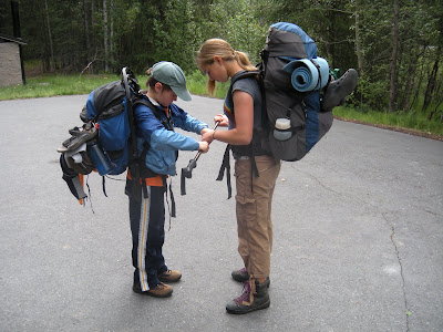
Since it is a point to point hike, we had to have a vehicle at both ends. My cousin recommended starting at the south end and hiking north since it is a long, gradual uphill, while the north end of the pass has a couple of steep, rocky climbs. After dropping one vehicle at the trailhead by Granite Creek off the Seward Highway last Wednesday, we drove the 35 or so miles to the other end, parked and doped up (bug dope!). For other backpacking trips we'd built up to it by carrying loaded or partially loaded packs on walks for a few weeks or months before the hike. This year we didn't do that at all, so I was curious to see how our bodies held up. Leaving the house, my pack was 45 pounds, Douglas's was 35, Denver's 30 and Aurora's 20.

The first day was sunny and we, being cool weather lovers, were dying in the heat, especially as we traversed areas that were not shaded. We began at 12:30, and our goal was a campsite 6 miles in at a river. We took water breaks every 30 minutes or so, stopping for a minute or two for everyone to sip (gulp!), and every 1 1/2 hours we took a 10-15 minute sit-down break. The trail followed the edge of a large lake for the first couple hours. Besides occasional patches of pushki over the trail, conditions were super. The trail was a dry, packed single-track that was fairly smooth and free of rocks and roots. As clouds came in, we were happier and more comfortable as well.

By 4:00 we'd made our 6 mile goal and the developed campsite (basically, a sign that indicated there was a flat place to pitch a tent). None of us felt like setting up camp so early, particularly since the bugs were annoying as we sat and took a break by the river. We decided to push on and stop for dinner somewhere before we set up camp if we needed to. We did not have a good map and there were no mileage or other signs on the trail, so we really had no idea where we were. We knew there were 2 lakes at the summit, but besides that we were just guessing where we were. 
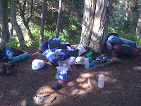
Two hours of hiking later, we had increased our elevation significantly and came upon a grove of spruce trees with a small stream next to it and a raging river nearby that we could hear but not see. We decided to make that camp, even though it didn't have a sign indicating it was a 'developed' campsite. It had a level spot for pitching a tent, a tree to hang our food in and non-glacial water nearby to pump and drink. Our basic needs were met.

Dinner was delicious: spaghetti with sauce and mashed potatoes with sausage and cheese. An hour after we'd arrived dinner was over, dishes washed, waterbottles filled, the tent up, food and smellies hanging from a tree, gear stowed under waterproof covers for the night and we were cozy in the tent playing a family cribbage tournament. It was a satisfying day. We figured we'd gone 8 miles that day, a pace of just under 2 mph.

The next morning we woke up at about 9 and began the process in reverse: let down the food from the tree, make breakfast (bagels with cream cheese and ramen noodles), pump more water, pack up sleeping bags, pads and tent, and repack packs. Aurora had complained that she wasn't tired at all the day before so we loaded her up, giving her heavier items from each of our packs. It took an hour from the time we woke up till we walked out of the campsite, moving about our tasks at a steady but not hurried pace.

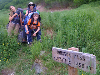
Only one hour after we began, we arrived at the summit, marked by a sign: Johnson Pass, Elevation 1450 ft. There was a pile of snow nearby (it is barely visible above my shoulder in this picture), but besides that, it was not an exciting moment. We'd been expecting to get above treeline as we'd done on other passes we'd hiked, but there were still willow and alder bushes around us at the summit and higher above us too. It did open up a bit, though, so we weren't in the tall trees and we could finally see further ahead and where the trail led.

Between the two lakes at the summit, a section of stream had rerouted onto the trail so we had a bit of muck hopping and branch balancing to do. Other than that, it was good hiking, though the further down the north side of the pass we went the more encounters with pushki over the trail we had. Doug did end up with a blister on one arm after that day, which wasn't bad considering how much pushki we'd plowed through. Some Silvadine, a medication I'd gotten when I burned my hand a few months ago, made the blister disappear overnight--to us a miracle as pushki blisters tend to itch, ooze and be a real pain. Now that we know Silvadine works on pushki burns, it is going to be a staple in our first aid kit (Unfortunately, it is a prescription only medication).

We didn't have a plan for how long we were going to hike. We kept asking each other, "How far are we going to go today?" and we just didn't have an answer. About 2:00 we stopped for lunch along the trail (soup, bagels & mashed potatoes with sausage) and sometime around then someone mentioned pizza and Coldstone ice cream and how good that would be. I asked the kids if they were willing to hike out that day (estimated at 15 miles) for pizza and ice cream and they responded with firm "Yes!" Without mileage signs we didn't know for sure where we were at at any point so it was hard to say where to stop. Plus, we didn't want to pitch camp and sit around for hours and hours. Thus, it was not a difficult decision to press on to the end, though our bodies were getting very tired by that point. I had a blister on one heel (the moleskin rubbed off) but I was fine as long as I didn't have to go uphill. The mostly smooth, downhill trail was a blessing.

At 6 pm we walked into the north trailhead parking lot. We'd been on the trail since 10 am, and we think 15 miles is pretty close to what we hiked that day. We met at least 15 mountain bikers the first day on the trail, but only 2 the second day. From what I hear, this is a very popular mountain biking trail, and I would enjoy it--early in the season before the plants overgrow the trail.

The only bummer of this trip is that I lost my camera the first 3 or 4 miles of day 1 near the south trailhead. It was clipped to my backpack belt. When I noticed it was gone during a water break, I took off my pack and ran a half mile or more back on the trail looking for it but never did find it. I asked some southbound bikers to keep an eye out for it and mail it to me if they found it. Thus, the pictures you see are what we took on Douglas's iphone. I am still holding out hope that my camera will be found and returned.

We were all proud of ourselves for accomplishing this hike, especially in 2 days. It has been over 15 years since Douglas and I have backpacked that much in a day, and I know our kids never had, though they'd done 13 miles a day on their previous backpacking trips (Chilkoot Pass and Resurrection Pass). This was a milestone for our family as well: we have never gone for a backpacking trip with just our family ever before. We'd always gone with my aunt and uncle and cousins, so it was neat for us to do this on our own. Our confidence level of hiking in the backcountry of Alaska has increased a lot in 4 years of living here. It is a good feeling to have, and I am now plotting the next backpacking trip for the family!

Addendum: Stan and Lisa found my camera on the trail and mailed it to me, so I have my camera back!! I am going to add 3 more pictures I think you would all enjoy. And a note to the prepared among my readers: put your name and address on your camera and anything else you would want returned to you if you lost it. This is the second camera we'd lost in 3 years. The last one disappeared around the Kenai River, but we didn't have it labeled so even if someone had wanted to return it, it would have been difficult. We learned from our experience!


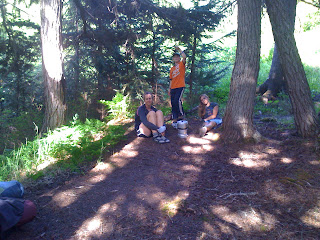
Aurora and Denver adjust the walking stick.


The trail followed the lake for the first couple hours. We didn't realize how big the lake was, but it kept going on and on!