Wednesday, July 29, 2015

Backpacking the Ptarmigan Trail


Thanks, Alisa Aist, for this beautiful photo of Ptarmigan Lake

This summer has been a series of last-minute trips since we're never quite sure when Aurora and Elisa have off from their internship with the Center for Alaskan Coastal Studies. The Ptarmigan trip was the first, back in June. The girls had Friday and Saturday off; Thursday evening the girls begged for a backpacking trip--somewhere! Any of the shorter trails are also less scenic, but this trail had been on my to-do list for a few years since we did a day hike to the lake and back while camping along the Seward Highway in the Ptarmigan Campground. It is 3.5 miles to the lake over gradual terrain (e.g.:  not a mountain pass!). It has been a couple years since I'd backpacked and I'd been having back issues so I figured this was do-able. Off we went despite a weather forecast for rain!

Besides going across Kachemak Bay to Kachemak Bay State Park, the nearest good, long hikes are in Cooper Landing, 2 plus hours from Homer. I consider that the biggest downfall of living here. Normally if we make a trip of 3 hours we want to go for the whole weekend, but that is more restrictive in finding camping spots or expensive cabins/hotels. So I threw out that attitude and that has allowed us to do the hikes we've done this summer.


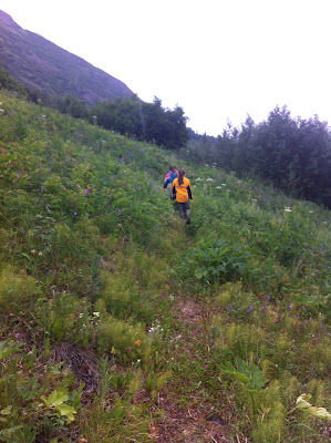
View of the hike, about mile 2.5 (picture by Alisa Aist)

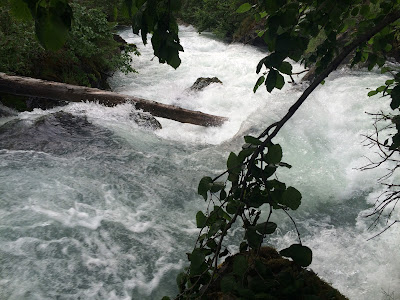
Ptarmigan is just over 3 hours away, a few minutes past Moose Pass on the way to Seward. The trailhead parking lot is adjacent the campground. Our packs were all loaded and ready to go so we just got on our footwear of choice and off we went. The first half mile or so is a very well developed trail, smooth gravel. At a turnoff it continues to follow Ptarmigan River, a gorgeous rushing glacial stream. I have special affection for this trail. We camped at the campground 10 years ago when we visited Alaska, before we moved here. I recall going a little ways along this trail and it was quite rough and seemed immensely remote. Now it seemed positively tame.


Beautiful campsite, with loons calling from the lake
An hour and a half got us to our campsite, a level area jutting out into the lake with rocks and spruce trees creating an intimate and peaceful setting. Some folks were fishing and had a hammock strung between two trees, but they were only day use so we set up our tents, pulled together day packs, and took off for the head of the lake, another 3.5 miles. There are 4 campsites along the lake, three of the clustered at the end we were at and another at the far end. There was even a bear container for food and smellies, and an open air outhouse:  the toilet with no walls.


The trail along the lake traversed across mountain meadows


The 3.5 mile long Ptarmigan Lake is hemmed in by mountains


Glaciers on the mountains feed the lake


The river at the head of the lake, taken from near the campsite


A study was being conducted along the lake

The equipment was wired off, probably with electric wire to keep the bears away


The hike to the head of the lake was uneventful and while it was scenic, I barely saw it as I was trying to keep up with 3 very speedy teenagers whose natural walking pace is far faster than mine. Occasionally they would stop to tie their shoes and I would catch up to them and catch my breath for a moment before they were off again. I'd been smart to insist on leading when backpacking in otherwise they'd have left me far behind.

Once back to the campsite the kids wanted to go explore. We could hear a waterfall nearby where the lake turned into a river. Turns out it was a rough trek to get the few hundred yards to the spot, but the wild rapids were worth it.

The kids looking towards the end of the lake where the river begins


The calm, smooth lake instantly turns into a maelstrom the moment it becomes a river
 (photo by Alisa Aist) 

Bear scat along the first 3.5 miles of the trial was nonexistent; along the lake we saw 5 or 6 bear scats that were relatively fresh. I wasn't too worried about it. Later that evening after eating dinner in camp, I walked the few hundred yards through the brushy trail to the pit toilet. As I came up to the main trail from the side trail to our campsite, there was a movement about 15 feet from me, a rustle and I saw a black furry back melt off into the brush. I was like, "Helll-oooooo!" knowing it was a black bear and that if he/she was displeased with me being there I would already be toast. I opted to continue to the outhouse, making more noise than I had been before.  After returning to camp I was telling the kids I'd just seen a bear and the bear itself, a fairly large blackie, came into view along the lake trail, heading up-lake, away from us. Apparently he'd been strolling the main trail when I disturbed him; he took a detour and once I was gone he continued on his way up the trail. The next day when we returned to the trailhead there was fresh bear scat not far up the trail where there had been none the day before.

I know Alaskans who won't hike in the summer because they are nervous about encountering bear. I am aware of bear mauling people. My experience encountering bear in the wild has been that every time they have avoided me, oftentimes quite vigorously, running away at high speed. I also know that I have likely had more bear encounters than I've been aware of:  they are all over and most of the time they do not make their presence known; they just slip off before we become aware of them. If I hadn't been so close to this one and facing it, I would not have known it was even there.

The hike back was speedier than coming since we'd eaten our food and I'd offloaded much of my load onto the kids (why didn't I do that the first day?!). It had been raining so the extensive grass hanging over the trail was wet and we were soaked in short order, but it was warm and we were exercising so we were not cold. It was a fun trip, despite being less than 24 hours. It whetted my appetite for backpacking, though I recognize that I am limited more by time than anything else since there are so many awesome hikes I want to do and not enough time to do them all!

Tuesday, July 28, 2015

Skyline Revisited

Hiking the Skyline trail near the Kenai Wildlife Refuge between Sterling and Cooper Landing is like visiting an old friend. This is one of our annual hikes--treks we make a point to do once every summer. This year saw some new side trails forged to avoid challenging sections, a development I appreciate (better footing; safer) and dislike (confusing to know which one to take). Trail use has increased greatly on Skyline since we moved here 8 years ago, and what was once a single ribbon of a trail up the 3000 or so feet to the summit now has widened as people continue to search for firmer footholds along the side of the trail on the steep, gravel-covered inclines. This trail has not seen any "upgrades" in years. About 10 steps were put in about 5 years ago in one section, but besides that, this trail seems completely untended.

The views of Skilak Lake are always a treat, as are the many smaller lakes and mountains. Once one reaches the summit it can be continued along the ridgetop and then a descent to the Fuller Lakes, making it a point-to-point hike. That's on my to-do list someday!


I love this grove of trees about 2/3 of the way up, almost to the saddle

Near the top--the area that usually is snow-covered latest in the season. No snow this year.
The "orange box" at the top for signing in the accomplishment

Aurora doing her juggling thing at the top

Monday, July 27, 2015

Hiking Grace Ridge '15

This is the third time I've hiked Grace Ridge. We are making this one an annual hike, despite the steep price tag of $85/per person (4 of us) on the water taxi. Perhaps it is time to befriend someone with a boat--or buy our own boat!

Mako's continues to be our water taxi of choice. We haven't had any problems with them besides being late on occasion, but that is to be expected with all the factors that play into across-the-bay travel. They also have a variety of different types of boats (landing craft, catamaran, skiff) for the varying conditions and pickup/dropoff types.


Homer Harbor on a calm, calm morning!
We chose our day well:  it dawned amazingly calm and clear. The boat ride over to Grace Ridge South was speedy and smooth. Mako Junior (not his name; the son of the owner) was our captain and he warned us the south end was pretty brushy. That turned out to be an understatement. But first we offloaded, agreed on a meeting spot for lunch with the speedy kids, and took a layer off from the chilly boat ride.


View of Tutka Bay near our dropoff point of Grace Ridge South

Calm waters looking towards the head of Tutka Bay

The ladder offload method
The beginning of Grace Ridge South:  the beach

Blueberries greeted us along the trail as we began the climb. So did one very messy area of downed trees, which ended up being the only downed trees on the trail the whole 7-8 miles. I was appreciative of being an agile and fit person for this obstacle as it involved going over and under a few trees!


Downed trees made a mini obstacle course

As we began to climb out of the temperate rain forest and moss-covered trees, the brush increased. Ripe salmonberries hanging over and along the trail tempted us, and I nabbed all the ones the kids hadn't eaten. The trail alternated between being invisible beneath the overhanging grass and being an absolutely perfect trail with no brush in areas with spruce trees. In the brushy areas there were times I would stop and look, unable to visually see the trail anywhere. Then I would look down and edge my feet along to look for the indentation of the trail on the ground. That made the hike a bit slower than it would have been under clear conditions.


Find the trail--if you can!
The brush was heavy with dew, so our pants and boots were soon soaked. Luckily it was a warm and calm day so it was not cold. We finally got above the tall trees into the shrubbery area (alders and elderberries and stunted spruce), and finally above treeline. But there are a number of false peaks so we would go up, then down, then up another false peak, then down, then up another peak. The climbing mostly continued till we stopped for lunch at a knoll at about the halfway point.


What not to do:  fuzzy pictures from putting my phone (camera) in the waistband of my shorts!
I was very bummed to discover when I got home that nearly all of my pictures from the top of Grace Ridge were fuzzy. I didn't have pockets in my shorts and for quick access to my camera I tucked it into the very sweaty waistband of my shorts. Mistake! Condensation ruined my pictures. I did manage to get one shot that turned out well. I probably held my camera in my hand for a few minutes while walking and the lens cleared off.


I love the sense of drop-off in this picture. The trail down is steep, but not a cliff!
It took us another 2 hours to make our way down to Kayak Beach moving at a good clip. There was a small section that was overgrown with grass, but the majority of it had been trimmed a foot on each side of the trail and the clippings raked off by trail crews, which made it feel like an expressway compared to our route up. 

Of course the kids ran down so they were busy tidepooling when we arrived at Kayak Beach. Curious to see if they'd found anything cool, I headed their way. Denver was waving at me to come, so I figured they must have found something neat. Neat indeed. It was an octopus!


Within minutes the tide had come in and the octopus was no longer visible, but I was impressed that the kids had had sharp eyes and found it. I've seen two octopuses in one summer, after not seeing any  before. What a treat!

A half hour past our pickup time, the Mako's landing craft skimmed into sight. It's a slick thing just walking right onto the boat. As we headed back to Homer I took a picture of Grace Ridge. As Denver exclaimed, it seemed so small! Funny how big it seems when one is going up it! It is 3105 feet so that's nothing to sneeze at for a good day hike.


Grace Ridge as we're heading back to Homer

Sunday, July 26, 2015

Climbing Hope Point


Wildflowers on trail up Hope Point trail

Friday evening while our family was flopped out in the living room after a busy day, Denver consulted his iPod and announced that the weather for Hope on Saturday was sunshine. Both kids looked at me expectantly, and I knew what question was coming:  "Can we climb Hope Point tomorrow?" I mentally took a deep breath and said, "I'm game." 

A few years ago we climbed Hope Point at the end of a 10-day mountain biking and mountain climbing vacation. We were near the top, with the actual top an unknown distance above us, when the clouds rolled in and obliterated our view. We made the executive decision to go down rather than push on to the top since we were tired--exhausted from days of breaking down our bodies. The kids have never forgotten it, and every summer summiting Hope Point comes up as a goal. Each summer we watch the weather on the weekends to see when we might make it happen as we didn't want a repeat of being socked in by clouds, and the trail is way steeper than anything I would want to do when it is slick.

Trailhead for Hope Point and Gull Rock 
So Saturday morning we left Homer at 8 and were on the trail by 11:35. The weather was warm:  I rarely start a hike with shorts and my short-sleeved shirt, but this time I did, and I only put on a long-sleeved shirt for a few minutes near the top when I took a break and was sweaty and the wind was chilling me.

The trailhead is for both Gull Rock, a 5.7 mile one way hike (the most non-descript, boring hike we have done in Alaska), and Hope Point (probably one of the most beautiful hikes we've done in Alaska). Shortly after we crossed the bridge and turned up the hill for the Hope Point trail, we were puzzled. None of us recognized the trail, which was unusual. I have a mind for trails and they tend to be imprinted in my mind. I couldn't figure out why it was completely unfamiliar. 
Trail construction sign:  rolling rocks
Then we came across a sign:  Trail Construction; rolling rocks. What? Rolling rocks? What rocks? We were in the middle of the woods; there were no rocks in sight. Right around there it was clear there was significant work on the trail. Trees were cut, the trail widened, and there were switchbacks that hadn't been there before. It made for some easy hiking. The switchbacks  were at such a gradual grade that I could dash right up them without a rest. We saw where the old trail had been, the part of the trail that kept me off it when it was wet:  steep and straight up the side of a mountain meadow. Now there was a virtual expressway up the mountain, or as Aurora put it, "What is this? An elevator to the top?!" While the kids were extremely vocal about their displeasure with the trail "upgrades," I just felt a bit queasy in my stomach. What was once a remote mountain climb was now a highly accessible trail. The sense was confirmed as we ran into group after group of people, many of them quite old and not your typical Alaskan mountain climbers. While it was nice to be able to dash up the mountain, it was positively overwhelming how many people were up there. What we had loved about that hike and what drew the kids back was how remote it seemed. With 10 other groups up there at the same time we were (busier than any other Alaskan trail I've been on besides Flattop in Anchorage and the Russian River Falls) as well as the trail crew that was putting the finishing touches on two years of work, it was anything but remote.

Lower trail, below treeline

Climbing up higher; substantial cuts for the new trail

Feeling like a highway across the once-remote meadow

Eventually the scars of the trailwork will grow over

A nice touch:  stone steps through one tricky area

The meadow that a few years ago one had to climb straight up

Once we got above treeline the trail improvements stopped and it was the "old trail" and while there were still plenty of folks up there, it felt slightly more remote. The herd of wild goats weren't grazing above the saddle, which wasn't a surprise. The views are still amazing.

The trail heading up with the goal the peak on the right

Turnagain Arm and the view towards Girdwood

More trail up, from the saddle. The last 15 minutes to the top

The view of Anchorage from Hope Point

The view of Hope from Hope Point
So while the beginning of the trail used to be more challenging and steep with the meadow climb, now the second half is more difficult. It took us an hour to get from the trailhead to the top of the meadow, and then another hour to get to the top. That was moving at a pretty steady pace. The top has a marker so that we knew we'd arrived.

We were sharing the top with some other folks. Amazingly there was barely a whiffle of a breeze and it was warm, so for one of the first times ever I sat comfortably in shorts and a short-sleeve shirt on top of a mountain in Alaska. Aurora's new thing is to bring her juggling balls up and juggle at the top of mountains we climb or hikes we go on, so we got the requisite picture of her doing so.


And for those who aren't inclined to make the 3630 foot climb, here is a video of the view, starting with the view to the north and Anchorage. On a clear day Denali would be clearly visible from here.


The spec sheet about the trail seems to have been updated since the trailwork began (it says 6/14, and they have been doing improvements for a couple years).

The trail specs appear to be updated with the new trail

There are plenty of other beautiful mountain views in Alaska. I am not sure why this particular mountain was chosen for such extensive trail renovations. I am so mixed about it. The joy of climbing a mountain is tempered by the fact that it was way easier than climbing any mountain should be. The meadow that was the glorious highlight of the hike is now criss-crossed by switchbacks and piles of dirt from the cuts. Time will soften those scars. I'll get used to the "new" trail and it will keep it accessible to be as I get older and climbing mountains gets more difficult. But I will still treasure the time we hiked it and it was the prototype of  what climbing a mountain in Alaska means to us.

Friday, July 24, 2015

Camping Right Beach


Sunset over Homer from Right Beach

It seems like every year when we go camping at Right Beach we do the same things:  kayak in Halibut Cove, jump off the rocks into the lagoon river, hike to the glacier lake. This year, though, Aurora and Elisa are interning at the Center for Alaskan Coastal Studies, so they help with tidepooling tours. Elisa is from Anchorage and we agreed to host her, so she is living with us for the summer. So when it came time to decide what to do, they clamored for tidepooling at Otter Rock, which is by the CACS Peterson Bay Field Station. It turned out to be a neat expedition.

The kelp covered rocks across this beach is Otter Rock
It was a quick few minute boat ride on smooth waters over to Otter Rock. We offloaded and then began exploring, with Elisa and Aurora being our guides. There were lots of gooey looking anenomes, oodles of starfish (which I now know should be called 'sea stars' as they are technically not fish), and plenty of hermit crabs scuttling about, along with a variety of other sea creatures. Then we hiked over to China Poot Bay, which is where the CACS takes people on tidepooling tours.

 Lagoon off China Poot Bay as the tide begins to come in
 A group was just leaving as we got to the beach. The leader was excited, telling us to check out Octopus Rock as they'd seen two octopus (apparently octopus is correct, not octopi). We made our way over there and sure enough, there were two octopuses squished in by a rock, looking like pink and white flesh. It was my first time seeing octopuses in their natural setting so it was fascinating.

Octopus in China Poot Bay
It was time to move on as the tide was coming in so we made the trek back to the boat. I am always struck by how neat the cliffs by Right Beach are, twisted in strange contortions.

Cliffs by Right Beach

Right Beach a few hours before high tide. By time the high tide hits there will only be a few feet of beach left below the grass.
Much of camping at Right Beach is waiting for the tides. When the tide is out we can walk to the lagoon, which is a fun place for the kids to play with the river with deep holes for jumping into and riding to current downstream. It's simple camping fun, which is what makes camping special.

A nice rapids is created by the outflowing waters

And then there is the hike to Grewingk Glacier. If the timing is right you can hike there and back via the beach, but we usually take the skiff to the Saddle Trail and hike from there, which makes it a short but beautiful hike.

View of the beach from the Saddle Trail trailhead in Halibut Cove

The start of the Saddle Trail

There were lots of boats moored off the Saddle Trailhead the day we hiked to the glacier lake

Trail crews did an amazing job cutting and raking the tall grass and shrubbery from along part of the Saddle Trail, which is being redone starting this summer
  
Almost to the glacier lake; following the cairns

Just a few ice floes on the lake this summer

But when we are not off adventuring, we were hanging out in camp and enjoying the view.

Calm waters at Right Beach, with oyster farm buoys visible in the distance
And then it is time to go...all too soon! All the gear (everything but the kitchen sink!) is loaded back up and kids gathered up and buckled into life preservers. Back to the boat launch in the Homer harbor, trash offloaded, gear divvied up and we head home to showers and the comforts of home, which we appreciate so much more having been without if for a few days!