Wednesday, July 31, 2013

Water Delivery!

Water delivery truck
Sometimes I still shake my head in amazement that hundreds of households in the Homer area, particularly on "the bench" below the ridge, have water delivered to their homes.  Water delivery trucks like the one pictured above are common sights around town.

We run out of water when our 1300 gallon bladder in our crawlspace is empty and we weren't paying attention to how much water we were using.  That is not a problem when it happens on a weekday, as our water company, Moore & Moore, is good about putting those who are completely out of water high on the delivery list.  But twice this summer we were gone on vacation and we ran out the weekends we returned, probably because our housesitter had to water the garden and greenhouse so much with this hot weather.  Either we call and pay the $25 weekend delivery premium or we just hold on till Monday.  We actually have a cistern in our cabin as well, so we are never completely out of water, we just have to haul it from the cabin and no showers for us!

The price we pay for an awesome view of Kachemak Bay:  water delivery!
At 5.5 cents per gallon, the water is not cheap.  Teenagers, watering the garden and washing the cars can all throw off our water consumption, which for years was a very steady 100 gallons per day.  I collect rainwater for watering the garden, though this summer it hasn't rained enough to keep us supplied. 

Most people have cisterns, either above or below ground, and are on a regular fill-up schedule.  When delivering to cisterns, the delivery guys blast the water at full pressure and when it comes out, the cistern is full.  With a bladder that doesn't work.  They have to run it at 50% pressure and they have to watch that they put in only the amount we request, which is usually 1100 gallons.

This is one of those things we've gotten used to, but it seems to me like an uncommon luxury to have a well with an unlimited amount of water--free water once that well is put in!  Every so often we dabble with the idea of putting a well in for outdoor water use or, even, we can filter the water in the house, but the water is so full of minerals that even filtering it would be costly, and it wouldn't fully clean the water.  Even the well drilling companies we talked to seemed to think it was a 50-50 proposition as to what quality and quantity of water we would get, and we wouldn't know until they started drilling. So we look at it as one of those things we just have to deal with to live here, and we are happy that we have water, because we know people who don't have water to their house in any form!

Monday, July 29, 2013

Climbing Bird Ridge

The view of Turnagain Arm from the highest point on Bird Ridge

One of my daughter's friends has raved about the Bird Ridge hike, which is about 20 minutes south of Anchorage along Turnagain Arm, comparing it to Mt. Marathon in Seward.  Both trails have races on them, though Mt. Marathon is up and down while the Bird Ridge race is just up.  Both have pretty hefty elevation changes, but the landscape of each are quite different, as I discovered yesterday when I did the hike.

We went into this hike without knowing much about it.  I'd climbed a short lower section of it a few years ago, but didn't have a clue about the elevation gain or trail conditions further up.  It was a hot day--somewhere in the 70's with only a few occasional whiffs of breeze--and a brilliantly sunny day.  We had 2 or 3 liters of water in our hydration pack and snacks for the top.

We parked in the overflow parking lot, hoping our vehicle would catch a little shade.  The trail begins with a nicely paved section, then a raised boardwalk, then nicely graveled.  Where it meets up with the other parking lot trail there is a restroom, and then the climb begins.  At first the trail is mostly protected by the trees, and already at 11 a.m. shade was on my mind.  There were rocky patches with no shade as the trail went up, up, up and always up.  It was just Aurora and I, and Aurora is in amazing shape and probably would have been happy to run up that trail.  For me, I huffed and I puffed and every so often yelled at Aurora to wait up so I could get some water (I made her carry the hydration pack in an attempt to slow her down!).

The rocky trail up with the view obscured by a fog that rolled in
We would look up and wonder, "Is that the top?" and we would get there and yet another section of trail rose above us.  Once we got up over the initial steep and rocky section the trail's incline, while less steep, was hard-packed dirt more often than not.  There were patches of alders and scrub juniper bushes that offered patches of shade in those upper reaches, though eventually even those petered out.  Birds did indeed flit about, above us, below us and around us, which I was on the lookout for since I wanted to see if there was a reason it was called Bird Ridge.

You can see the trail following the spine of Bird Ridge

I was a bit annoyed by the crowds of people on the trail:  we met 15 people or so the 3 hours we were on the trail so that is Alaskan standards of crowds.  But what was more annoying was climbing at the same pace as other people and having to listen to their conversations.  Eventually we left them behind as Aurora set a steady no-breaks pace (except to wait up for me, and once I drank some water, off she went again).  I was happy that most everyone had their dogs on leashes and their wasn't too much dog poop on the trail.

Finally, we were sure we saw the top:  it was a finger-like promontory and it seemed the mountain was about done.  Nope.  We got there and there was yet another outcrop beyond it.  Aargh!  But I appreciated that there was a stake driven in at the highest point so that we knew we'd indeed arrived.  It had been a long hour and a half, and in that time I'd only caught my breath once, when we'd stopped to admire the view long enough for me to breathe.


Heading back down, Aurora wanted to run.  It didn't help that a very fit older man jogged past us; I could see Aurora itching to take off and keep pace with him.  I was tired, but now that it wasn't a cardiovascular challenge I figured I'd let gravity do it's work and pull me down the ridge, particularly on the better trails up high.  Well, this was my first climbing hike of the summer, so about a third of the way down I started feeling my legs, and by halfway down by knees were screaming, my quads and glutes were cramping and blisters were popping up on my feet.  I kept looking down thinking that the cars on the Seward Highway below still looked awfully small and they weren't getting bigger fast enough.

At this point my goal was simply to make it back to the car--not keep up with Aurora, not go fast, not look good.  Stopping was not a pleasant choice because by now the flies were horrendous.  When Aurora would stop and wait for me I could tell how close I was getting to her by the volume of the slap-slap-SLAP as she smooshed flies.  Even when I got to a flat section, my legs were still screaming, though a slight uphill near the end was a welcome relief.  It took us an hour to get down the 2 1/2 mile trail from the top.

Later that evening, back home and soaking my blood-blistered feet in peroxide water, I looked up the elevation change of the hike.  Aurora guessed it was 3000 feet; I guessed 2000 feet.  Boy, was I ever off!  The DNR website says this hike is a 3505 foot climb.  Yikes!  I felt horribly out of shape on that hike, and I am going to be feeling this one for a week (today, my quads are seriously sore!).  Once I found out it was over 3500 feet, I mentally readjusted and now I think I'm in pretty darn good shape to do that hike in an hour and a half up, in the heat, first climbing hike of the season.

The views of Turnagain Arm and the Chugach Mountains were tremendous, and while I do like the hike more than Mt. Marathon in Seward, I actually think the view is prettier in Seward (Resurrection Bay, glaciers, more snow on the mountains).  The Bird Ridge trail has more vegetation, flowers, grass and birds than Mt. Marathon, making the hike itself more scenic.  I'll do this one again...someday....  Next time I'll have to psyche up to do it, though, because now I know how high it is!

Thursday, July 25, 2013

Cooper Landing Revisited

We got hooked on Cooper Landing as a vacation destination last year with our mountain biking/hiking/rafting adventure, but hadn't done everything we wanted to do last year so made a point to go back for a shorter sojourn this year.  Johnson Pass, Crescent Creek and Russian Lakes trails all beckoned us and I've blogged about those, but I thought I'd give an update on this year's trip.

Bears played a big role in this year's camping vacation.  We were staying at the Cooper Creek South Campground in Cooper Landing.  A notice at the checkin kiosk said that a bear had damaged tents in the campground just 3 days before so we were on high alert for bear safety, keeping most everything we weren't using in our vehicles all the time and strictly enforcing no-odor stuff in the tents. 

A day or so later Aurora was just past our car heading to the bathrooms when she noticed a brown bear not 25 feet away.  It was walking from the creek to her right towards the campsite across the road from us, leaving a wet path.  It sniffed around that site a bit (it was unoccupied), then headed on through it and disappeared into the brush, away from our site.  We were just starting to make dinner (it was about 6:15) so we were a bit apprehensive.  We drove to the bathrooms, then circled around and reported the bear to the campground host.  They thanked us and said the bear had walked right by their site and on through into the woods.  We were a bit edgy the rest of the evening, but it sounded like it was passing through.  We'd gone walking on a trail behind the campsite the evening before and come across brown bear tracks (claw marks obvious as they down retract like black bear claws) so it was no surprise they were around, it was just a surprise to see one mosey on by our site without even a glance at us in broad daylight!  It was a smallish brown bear--like the size of a big black bear.

Not a great picture, but brown bear is running across road, almost in woods in Russian River Campground
The next evening we went for a hike at the Russian River Falls trail just down the road.  Afterwards we decided to check out the campground since we'd never driven through there before.  We drove around a curve in the road and saw a large brown bear in the RV dump station pull-off.  We stopped and the bear ran out to the road, then ran back to the dump station, then ran back across the road into the campground.  This was a different experience as it was bigger and it seemed agitated and we could sense the immense power in those massive paws.  We felt bad for scaring it into the campground.  We reported this one also but the attendant seemed indifferent.  Could be they see lots of bear in that campground!

While Aurora and I were biking/running Johnson Pass, Denver and Douglas ran down to Girdwood and they saw a black bear while out hiking to the hand tram and watched it for awhile.  Funny how black bear holds so little fear for us compared to brown bear!  Besides seeing 3 bear (our first brown bears seen on the Kenai Peninsula in 6 years of being here), we just saw lots of bear scat everywhere we went--some of it quite fresh.  The bears are eating plants right now as the scat was green and uniform colored.  It will change as they eat more berries, and salmon.

Regarding that Russian River Falls hike.  It is a nice, easy 2.3 mile hike out to the falls on a wide, gravel trail.  Families hike it, bike it, run baby strollers along it.  We've seen the price to get in and park at the trailhead parking lot nearly double in the 6 years we have lived here, so $11 per car per entry, for 12 hours, no re-entry allowed, seems like a rip-off and irritates me.  This has got to be a big, fat cash cow.  There were no bears at the falls and the fish weren't jumping, but there was a slew of salmon at the bottom of the falls, milling in a writhing mass of red-tinted bodies (the sign they are dying), which was fascinating watching.  For us this was a very mellow evening hike though seeing the brown bear afterwards was exciting.

We also went back and visited the Catholic church a mile down Snug Harbor Road.  During my painting class this spring I painted a picture of the cross up the 200 foot climb above the church and I wanted to go back and see it again.  The contours of the mountainside were so familiar to me as I'd spent hours on them--painting them--and I observed the difference in light and my portrayal of colors.


Besides that we discovered the joy of taking showers while camping:  Wildman's has 10 minute hot showers for $4.25, which we appreciated beyond words after spending a day of intimacy with pushki, bugs and sweat biking the Russian Lakes trail.

And a trip to Cooper Landing didn't seem complete without a visit to Sunrise Cafe, though we opted for a heavenly piece of peanut butter cheesecake pie and cole slaw instead of dinner!

It still makes me shake my head that I like Cooper Landing, of all places, to vacation.  But I recognize that others like it too, which is why this time we got reservations at our campground instead of leaving it to chance that a spot would be open (there would have been since we were there mid-week).  And I still detest driving through Cooper Landing because the roads are horribly rutted and curvy and traffic is slow.  That will improve a bit when the paving project through there resumes soon (suspended for the month of July due to high traffic volume).  But if I want a good take-off point for lots of hikes and bike rides, this is a great place to be!

Wednesday, July 24, 2013

Biking the Russian Lakes Trail, Point-to-Point

A view of trail and mountains from the upper end of Russian Lakes Trail.  This section was fast and fun.


We ran out of energy and time on our Cooper Landing vacation last year and I have been dreaming of doing the Russian Lakes Trail ever since, so was thrilled that it was actually going to happen!  I feared weather or injuries or bike malfunctions might sideline us from this trip, and it almost did as Douglas' knee was hurting him badly the first few miles of this ride until he adjusted his seat.

There were plenty of bridges along this trail.  Here, a section of the stream was washed out.   

A view of the stream and area from the bridge pictured above.

In the end, it happened though.  We started by parking one vehicle at the Resurrection Pass trailhead in Cooper Landing.  We drove 30 minutes up Snug Harbor Road which turned into the Cooper Lake Road.  It feels like a long, long drive on gravel, and luckily road conditions are good and traffic light.  As we drove it seemed we were going up and up, which was exciting to think we would be biking mostly down!  Yes!

We parked at the Russian Lakes trailhead.  Apparently it is also the trailhead for the Resurrection River trail that goes to Seward (The Forest Service website describes this trail with this warning: "Travel on this section of trail is for those who seek risk and solitude, are self-reliant and want a challenge.).  There were Forest Service trucks parked at the trailhead and signs warning about construction on the trail.  That could be a good thing or a bad thing for bikers, and it turned out to be a very good thing for us.  Four-wheelers on the trail meant that heavy overgrowth was matted down to the width of a 4-wheeler, which made for easier riding the first 5 miles that were being worked on.
 
This section of trail would have been more difficult to bike if we'd been going uphill rather than downhill on the soft dirt.

In addition to the 4-wheeler tracks, there was a section of trail that looked like a bulldozer had come tearing through.  Stumps were ripped out and piled along the trail, dirt was leveled out and gravel put down.  It was a startling evidence of civilization and progress that we don't often see in the backcountry.  Bridges, however, were plentiful signs of civilization.  On a less-used/developed trail we might have just had to ride through little streambeds, but there were bridges over them on this trail, which made for a faster ride.  Denver had a run-in at one bridge when a flock of about 10 prairie hens (we call them stupid birds) flew up into his face and in trying to avoid biking into them he took a face-plant off his bike onto a bridge.  As the rest of us caught up to him, one of the birds was still on the trail, and as we patched him up with bandaids we could hear a cacophony of cluck-cluck-clucking emanating from the bushes around us.

Can you see the trail....or the biker just ahead?  This should be titled:  Swallowed by Pushki

The moment we got past the 4-wheeler traversed area, the pushki towered above us.  True, in places it was ferns, fireweed, grass, elderberry bushes or alders that towered over us and crowded us on the trail, but it was the pushki that was most common and most detested, knowing that it could cause blistering burns if the day became sunny and the photosensitivity effect took place.  The bugs were horrible.  Each time we stopped, even for a few moments, flies would descend upon us.  Like I mentioned in the Johnson Pass blog, eye protection and keeping your mouth shut are two awesome pieces of advice I can give anyone doing this trail.

A porcupine climbing a tree next to the trail was a highlight.
We saw moose droppings along the path and bear scat became more common the closer we got to the Lower Russian Lake.  We met only 2 people on the first19 miles of trail:  a couple backpackers near the Upper Russian Lake, and we saw a porcupine climbing a tree right around that time too.  In the last 2 miles of the trail we saw dozens of people, most heading to the Russian River Falls.  That was it for the wildlife, though.

This trail is 21.8 miles long with an elevation decline (since we started at the top) of 1100 feet.  It wasn't as if there weren't any uphills, but there weren't any really long uphills.  There were a few short spots that we had to walk our bikes on particularly rough, rocky uphills, but mostly this felt like a relativly easy ride.  A big part of the fatigue of these rides seems to be mental:  moment by moment you have to be paying attention to the trail, looking, watching, evaluating speed, slowing down, speeding up, maneuvering, balancing, judging.  There are very few sections on any mountain bike rides where I can glance at the scenery or off the trail for more than 2 seconds, and when I do I seem to end up riding off the trail.  When I look back over this day, I can think of a number of potentially dangerous situations:  times that if we were not paying attention we could have biked off the edge of a ledge, flipped over the handlebars or something.  Fatigue could turn a relatively easy ride into a bad situation quickly, so I monitored myself and the kids, watching for signs that we needed to take a break.
There weren't many good stopping places with a breeze;
this was as good as we got for a lunch spot.  We didn't get eaten.

By time we reach the turnoff to Barber Cabin at mile 18 or so, we were ready to welcome the nicely graveled, wide trail.  And that last mile or so to the trailhead is just a screamingly fun, fast ride.  The crowds of people with small children, strollers and fishing rods were the only thing we had to really look out for.  We had a mile or so to ride to the Sterling Highway, and a quarter mile on the highway itself to the Resurrection Pass trailhead (we opted to do that to save on the $11 per vehicle/no re-entry at Russian River Falls/Campground trailhead, which would have added up for each time we came in to drop a vehicle and then pick up after).  Denver needed to get 25 miles in to qualify for a ride for his Boy Scout merit badge, so while Douglas and I drove back up to the upper Russian Lakes trailhead to get the car, he rode 1 1/2 miles around the parking lot to get his 25 miles in.

This is a typical view of the trail from about miles 15-19, near the Barber Cabin turnoff of Russian River Falls trail.
I look forward to doing this trail again.  It was not as cardiovascularly taxing as some of our other bike rides, and besides the pushki hanging over the trail, it is really a very fun ride.  Regarding the pushki:  I spent so much time being intimate with pushki this week.  While I will avoid it if I can, I spent hours in it and lived to tell about it--though getting a shower at Wildman's in Cooper Landing after the ride might have helped!  None of us ended up with blisters, though Douglas and Aurora had a few sores that might have been from pushki.  I would not need to get as psyched up for this ride as for some, though the point-to-point is inconvenient.  I could do it from the lower to the upper, but I'd really rather not.  It was just too much fun doing it this way!

A rare moment:  I stopped and got a shot of fireweed with Lower Russian Lake in the background.

Biking the Crescent Creek Trail

Last year during our Cooper Landing vacation we biked from the Quartz Creek Campground to the Crescent Creek trailhead and then on up the trail.  That extra 3 miles from the campground to the trailhead did us in, along with mechanical problems, so we didn't make it more than halfway to Crescent Lake last year.  That is why this year it was on my bucket list to make it all the way to the lake.  It is just 6.4 miles and rated easy so I thought it was perfect for the day after Johnson Pass.  It was just about right.

The trail is in fairly good condition with moderate uphills.
Although this trail is rated 'Easy,' it is not necessarily easy.  The elevation gain is 865 feet in the 6.4 miles, and while there were no places that were particularly steep, it was just up-up-up or flat nearly the whole way it seemed.  It wasn't until we turned around, though, that we realized just how much was uphill.  Even on the flats we were flying on the way back.  There are quite a few hairpin turns, which on the uphills were made challenging by rocks scattered strategically in our path on the turn, and a bit difficult on the way down because of the speed we were going.  There are rocks and roots as well as wide, pine-needle covered corridors and narrow paths across talus slopes above dropoffs to a rushing river (which we walked).  However, we did manage to go the 6.4 miles to the lake in 1 1/2 hours, and it only took 50 minutes to get back.

There were some very nice bridges along this trail.
Up at the lake there are 2 cabins for rent from the Forest Service and quite a few nice camping spots.  I was surprised to see a sign pointing the way to the "Beach Access," but what we were greeted with was not what I'd pictured:  it was a tiny gravel bar along the lake.  The lake by the beach was shallow (just a few inches deep), which is unusual for these mountain lakes.  The lake branches when it gets to the lake, with the trail to the right going to one of the cabins and it follows to the other end of the lake where you can descend the Carter Lake Trail.  It is 17 or so miles from the Crescent Creek Trailhead to the Carter Lake Trailhead, but it is not bikeable.  Apparently it gets too overgrown in the summer so it becomes a case of bushwacking.  To the left at the Y is a beautiful bridge, campsites, the other cabin and beach access.

"Beach access" at Crescent Lake:  a gravel bar
I recall this trail being very busy last year, but we met only one other party of 5 bikers who were loaded down, so obviously they'd spent at least a night.  (Frankly, I can't imagine biking that trail with a loaded bike--the the folks were easily in their 60's I'd guess.  They were heading downhill and they looked tired.)  It helped that it was mid-day during the week, and our experience of the trail would have been very different if we'd kept meeting other parties as the trail is narrow and one or the other would have to stop to let the other by.  There were few areas that were overgrown and we didn't need to worry too much about pushki, which also made this a more pleasant ride.

The water of Crescent Lake does not appear glacier-fed (it was clear), but near the mouth of the river a glacier-fed stream feeds Crescent Creek

While this trail can be a bit of a challenge with the uphills, this is a good introductory mountain biking trail for families who are willing to take their time and want a challenge.  We did the whole thing, including lunch at the lake, in 3 hours.  And the ride back to the trailhead from the lake is an amazingly fun ride.  It is worth it just for that!

Biking and Running Johnson Pass

Since we backpacked Johnson Pass a couple years ago, Aurora has wanted to run Johnson Pass, or at least do it in a day.  This was the year to make it happen.  Running 23 miles is just not my thing, so I said I would bike it while Aurora ran it.  We planned another camping trip around our bucket list (blog posts about those coming too) and off we went.

One of the two lakes at the summit of Johnson Pass
The day of the run dawned.  I had my biked geared up (pump, repair kit) and backpack packed (food and drink, extra clothes, sunscreen, bug spray, emergency supplies) the night before so just the cheese and sausage and Odwalla's (fruit smoothies) needed to be thrown into the bag.  A quick drive from our campground in Cooper Landing got us to the southern end of Johnson Pass.  Mosquitoes were swarming and I sprayed, which seemed like an effort in futility in the face of the aggressive bugs.  I velcroed the bear bell to the handlebar of my bike and off we went.

As we headed past the first lake, a float plane flew over and dropped off 4 folks that we met on the trail.

The elevation change of Johnson Pass is 1000 feet over the 23 miles, so that's a pretty mellow incline.  The trail started off rough and rocky.  Within a mile of starting, Aurora in the lead, I heard a squeal and high-pitched screams.  Rounding the bend, Aurora was excitedly chatting with a couple of her good friends (plus moms) who were just finishing 4 days backpacking the trail.  They gave a us a trail report:  few downed trees, pushki over our heads and plenty of fresh bear scat.  They offered us their bear spray, which we declined.  I figure that by time I get it out it would be too late anyways if a bear was really that aggressive, and I was counting on our bear bell scaring away the normal shy bears.

The trail was nearly obscured by pushki and tall grass in some places.


Soon after we began to climb, slowly but surely.  It was insidious:  a short, fast downhill, then a longer climb.  Those elevation gain descriptions can be deceptive since there are many ups and downs in the course of going up 1000 feet.  On the relativity scale of ups-and-downs, this trail wasn't bad. After the rocky patch the trail was pine-needle covered for miles through the forested trail.  As it neared the lakes, the trees were poplar, there was more pushki hanging over the trail (pushki like sunshine), and the trail leveled off.  It was nice having the trail flatter, but because the pushki was obscuring the trail I couldn't see what shape the trail was in.  I unexpectedly hit many rocks and was bounced around.  There were just a few places on this whole trail I had to walk the bike.


The trail in the pass, before beginning a long, gradual descent.  It wasn't quite as grown over here.
Once we started descending towards the north end of the trail, I kept thinking, "We're almost there," but it went on and on and on.  I was sure we were just 15 minutes from the end, particularly when we could hear cars zooming by on the Seward Highway, but no, it was a situation of getting into mental zombie mode and just keep going because what else can you do, after all?

There are a couple amazing waterfalls along the Johnson Pass trail.  Here is one, seen from above.

We ended up completing the 23 miles in 4 1/2 hours which is just over 5 mph, stopping just twice for 5 minutes to eat and various other times for quickie breaks.  Slow!  And yet I put this in the category of "I did it!"  For Aurora the run was just plain fun.  She didn't have to wait up for me too much on the uphill, and once we got through the flat-but-rocky-pushki-covered section, I had to brake quite a bit to stay behind her so she was able to stride out more.  When we finished I joked that she could run another 3.2 miles and say she ran a marathon.  I think she was tired because she didn't respond.

My trusty bike.  I am getting better on my less-maneuverable 29" wheels.  North trailhead checkin in background.

I have a few crucial pieces of advice for someone biking this:
  • Keep your mouth shut while going through sections of pushki.  I got a mouthful of pushki blossoms more than once.  Luckily the sun doesn't get into my mouth often so I didn't get blisters!
  • Take lots of bug spray and reapply liberally each time you get off your bike.
  • Wear eye protection!  Between the bugs circling and the pushki hanging over the trail, I got things in my eyes more than once.  If it is too cloudy for sunglasses, just wear non-darkening eye protection.
  • Be ready for a bumpy ride!  While this wasn't as bumpy as, say, the Primrose Trail, it had rocks, roots, drainage ditches, mud that was dried into bumpy shapes.  
  • This would just be more fun in June before the pushki is so tall, though it is certainly do-able any time.

Thursday, July 11, 2013

Biking the Old Sterling Highway/North Fork Road Loop

Some memories are seared into one's psyche, and my memory of a hellacious drive up North Fork Road to the Russian village of Nikolaevsk to watch Aurora's basketball game a few years ago has kept me as far away from North Fork Road as I could be.  That day a thick, heavy snow was falling and there were 8 inches of wet, slushy stuff over a winding, hilly gravel road.  I didn't know where the turnoff to the school was, and visibility was virtually nil.  I crept along, trying to stay on the road while straining to see up crossroads for a sign indicating where to turn. Today's bike ride imposed a positive experience over that so I won't be dreading driving it quite so much in the future.

We started at a friend's house off the Old Sterling Highway, where we were greeted with a "halll-ooooo!" from the house and a luscious plateful of fresh fruit (I think I need to go visit that friend more often!!), which went delightfully with a sunshiney, warm blue-sky day.  My crazy friend sent us on our way with a song, which was a fun start to our ride.  So down the Old Sterling Highway we went, starting near the intersection of the Sterling Highway with the Old Sterling Highway nearer Homer.  It was paved, mostly flat, warm in the shade with only light traffic.  The natural gas pipeline is being put in along the road, so there were some construction crews and we got stopped a couple times for that (I appreciated the breaks!), but mostly the 9 miles of the Old Sterling Highway flew by as we passed wildflowers, bogs and little bog lakes.  We cross the wooden bridge over the Anchor River, then up a hill to the intersection of the Sterling and Old Sterling Highways in Anchor Point. 

A cute, old cabin along North Fork Road

A short little .2 mile jog to the left onto the Sterling Highway got us to the beginning of North Fork Road.  From there it was more smooth sailing:  mostly flat, good pavement, wide shoulder and still the traffic was light.  After about 4 miles the pavement narrowed and became curvy and slightly hillier.  All told, we got 8.6 miles of pavement on North Fork Road before we hit the gravel.  And once we hit the gravel, we began to have more hills.  Up a hill, down a hill, around a curve, repeat.  It wasn't bad since the hills weren't huge and the scenery was amazing.

Mount Illiamna and Cook Inlet in the distance, with a bounty of pushki in the foreground
Broad, sweeping views of Cook Inlet and the Alaska Range greeted us as we biked higher, and about 2 1/2 miles past the end of the pavement we reached the highest point along North Fork Road.  The gravel road was packed hard and dirt, so was almost as good as pavement though we had to dodge some potholes and washboards and watch for loose gravel on the curvy downhills.  Few cars passed us so we didn't get dusted often and a brisk breeze blew it away quickly.  The temperature was right around 70, which is about as warm as it ever gets in this area, and for a change the breeze was warm rather than cool so we didn't need jackets (which was good because we hadn't brought them!).

The 9.3 miles of gravel road on North Fork Road was in good condition, belying the mess spring breakup makes of this road.
After the highest point we still had some uphills mixed in with longer downhills, till we got to "the awesome downhill":  a long, curvy swath that zipped us from the panoramic views right down to the flats of the river basin in a few short minutes.  On the ride down we got views of Diamond Ridge and beyond that the Kenai Mountains. Two miles on the flats got us to the intersection of the Sterling Highway with North Fork Road.

Diamond Ridge and Kenai Mountains.  I took this picture after our bike ride when we drove it to get mileages.                     I wasn't going to stop on the downhill just to take a picture!
Nearly a mile on the Sterling Highway was the one section of the ride I was dreading.  Luckily no semitrucks passed us in the few minutes we were on it, but campers, RVs and pickups cut it closer than I was comfortable with even though we were riding on the shoulder.  I had my brilliant Homer Women's Nordic biking jacket on so they couldn't miss us.  Those were mostly certainly the only rude drivers we met during the 2 1/2 hours we were out there, and while getting groceries in Save-U-More after the ride a guy who'd passed us (a complete stranger) asked us how our ride was.

So this loop is 27.7 miles, which is a nice, comfortable ride.  Of that, 18.6 miles were on pavement, and was easy riding.  We definitely chose the right direction to go for the easier workout:  if we'd gone up North Fork from the south towards Anchor Point we'd have faced that huge hill, and if we'd taken the Old Sterling Highway from Anchor Point towards Homer we'd have had a slight uphill rather than the slight downhill.

As I bike more I've been looking for longer rides around Homer, and I've just found my favorite.  I'm looking forward to doing this one again.  Hopefully similar conditions will prevail!


Wednesday, July 10, 2013

Diamond Creek Trail Update


I am waiting for the day that this entire trail breaks off and slides down into Diamond Creek.  In six years of hiking this trail I have seen mudslide after mudslide obliterate sections of this short little trail.  A few days ago, though, it seemed like there was more water going down the river than we'd ever seen before.  It took the kids a lot of work to get across the stream that normally they can clamber over quickly.

The most disquieting aspect of this hike was seeing a crack in the trail.  I've never been there when a slide happened, and I've never seen where the next slide was going to happen, but seeing this crack on the trail (and making jokes, "Don't step too hard there!") brought the reality home a bit more.  More than ever before, the trail was one big slippery slime path that required careful footing and grabbing onto handy alder trees.

We always enjoy a picnic at the bottom, watching sea otters and seabirds swim by and poking among the high tide debris for treasures.  This time a geocache was a neat find.  I'll keep you posted on this trail and will get pictures when it finally goes kaput!

Monday, July 8, 2013

Hope Viewing Area and Bike Path, Seward Highway

Our introduction back into civilization after camping, hiking and biking for 3 days was the pull-off at the bridge where the road to Hope cuts off.  There is an 8-mile or so stretch of beautifully paved bike path from the Hope Bridge (I don't know if that's the formal name but I'm going to call it that), following alongside the Seward Highway from the cutoff to the Johnson Pass trailhead.  I've often wanted to bike it but have never had my bike or the time to do it.  We decided it would be a nice, mellow thing to do before we headed home.  The bike ride was mellow and fun, but the parking area was insane!

We've driven by and noticed two coffee trucks parked in that parking area before and wondered how they ever got enough business to sustain themselves way out there, well over an hour south of Anchorage and in the middle of, quite literally, nowhere.  Now we know.  From the time we pulled into that parking lot, tour bus after tour bus stopped, spit out folks who queued up for either the bathrooms or the coffee shops, snapped a few pictures, got back on their bus and away they flew up the road to Anchorage or down the road to Seward.  RV after RV, campers, cars and more streamed in with people getting their pictures taken with the view.  Doug and I looked at each other, puzzled.  The view was so boring compared to most views we see in Alaska--rolling hills (not even mountains) with a river rushing by (which you couldn't see in the picture anyways).  No peaks, no snow, no cliffs--none of the stuff we would expect someone to get a picture of.

So we crashed this tourist party with our grimy, smokey selves, got on our bikes and enjoyed the ride.  As long as you can ignore the highway with tons of traffic zooming by (day after the Fourth, and a Friday, and the beginning of dipnetting season on the Kenai Peninsula), it is a very pleasant ride.  We had a headwind the whole way out so I was looking forward to turning around and getting that wind on my back.  There were rolling hills and then flat sections, which we discovered when we finally did turn around that the flat sections were actually gradual uphills, so gradual we hadn't realized we were going uphill.  So when we turned around we cruised.  It was so sweet!!

We went almost 7 miles out and then back, so a nice 14 miles.  It was just about right.  Granite Creek Campground is right along this section of paved trail and Johnson Pass is at one end of it so we very well may be back again.  I don't know if I have ever, in 6 years of driving along here, have seen anyone biking or walking on this bike path.  But then, when I'm driving I only go by for a few minutes every month or so so I could easily miss other users.  We had it to ourselves.  I don't think I'd want to rollerblade it:  we were going 20 mph on our bikes and I just don't see myself braking that on rollerblades!

Palmer Creek Road: Old Mine and Waterfalls

Our style of exploring new places is to drive down random roads that look interesting to see where they go.  The first time we drove down Palmer Creek Road, it was only my stubbornness that kept us going the 7 miles to the campground (Coeur d'Alene).  I'm glad I was stubborn because in chatting with a lady at the campground we discovered that the road, that continues 5 miles past the campground (though significantly rougher), heads up to an old mine and a waterfall.  Thus, after hiking 10 miles out to Gull Rock, getting some food in us back in camp, the restless kids talked us into driving back up Palmer Creek Road to check out the mine.

The view towards the mine from where the road was blocked off and we hiked.
Trails.com has a wonderful, succinct description of this area that I copy here:

"High in the hills above the old mining community of Hope is the scenic valley of Palmer Creek. Here, waterfalls and weathered hemlocks punctuate the rolling tundra. Higher yet, a hanging valley cradles two alpine lakes. This is a delightful day trip for children and agile grandparents alike. The only sobering note is the last 5 miles of road—high, narrow, winding, and slow, but normally drivable in dry weather by passenger cars. The road is unsafe for large campers and trailers but is good for mountain bikes. Gold was first discovered along Palmer Creek by George Palmer in 1894. A rush to the Turnagain goldfields took place in 1896. Two towns, Hope and Sunrise, grew out of the rush, and as many as 5,000 people were reported living in the area in 1898. Palmer Creek was the site of early placer mining and, later, lode mining, beginning in 1911 with the Lucky Strike vein. The Lucky Strike and Hirshey Mines figure in the hikes offered here. Active mining continued into the 1930s, and some people still have claims in the area today."

A stream crossing aided by old mining paraphernalia.  The trail up to the falls goes right up this slope.

Leftovers from the old mine.  A couple pipes were alternately buried and exposed on the hillside up to the mine.

A view of the valley we'd just come up (driven and hiked), from just below the mine entrance.

The mine was up 2 more switchbacks from where we stopped (14 miles of hiking that day took their toll on me!).

The mountains above us were shrouded in fog, with an old stone building in the foreground.
Where the road was blocked off, the trail began in good shape, but as it made it's way upward it was rougher, and in places the trail was a river from melting snow.  We only saw the entrance to one mine on the mountainside above us, though the trails.com description mentions two (There were two pipes traversing the length of the trail, one originating at the mine we could see.  Perhaps the other went to the other mine).

The trails.com calls this a day hike; we managed to do it in less than a couple hours, but there was much more to explore.  The trail to the falls, which took off to the left at the stream crossing, looked like a mountain goat path, hugging the side of the hillside.  Apparently that trail can be the take-off point for exploring other ridges and peaks, including above the mines.  There were a few tents set up along the 5 miles of road from the Couer d'Alene Campground up to the mine parking area, and what looked like designated camping areas (free, of course).  If someone wants a really backcountry, remote experience without backpacking, this is totally a great choice.  It feels so wild and far away from the world.  We didn't see any wildlife, though there were many beaver dams along both sides of the road from the campground to the mine parking.  I can see going back here sometime.  It would be fun to explore more and the road past the campground is also very bikeable.  Once again, put that one on the schedule for Denver's Boy Scout troop to do someday!

Gull Rock Trail in Hope, AK

We woke up to our first morning in Hope to scattered showers as well as to sore, tired muscles.  We'd all slept in late and it didn't look like Hope Point was going to happen so we considered some alternatives:  Gull Rock hike or the old mine up Palmer Creek Road.  Turns out we would do both, but at the time we didn't know that.

From the Porcupine Campground, a very nice, graveled trail connects to the Gull Rock trail, a 5-mile trek out to, we assumed, Gull Rock.  What the significance of the rock was, we didn't know.  Because the beginning of the trail was so nice and Aurora was itching for another long run (15 miles the day before on the Lost Lake Trail wasn't enough apparently), we decided we would bike it and Aurora would run. 

It was somewhere between mile 1 and 2 that we ditched our bikes in the woods on the side of the trail and decided to hike the rest of the way.  Once again, rocks and roots were our demise.  It would have been a difficult trail to bike as there were talus slopes to cross, boggy sections, and overgrown spots.  There was about an 800 foot elevation change over the course of the trail, but they were long, gradual climbs or descents mostly so that was less of an issue.  But we were tired from the day before and had less patience with climbing off our bikes often.  There was one section that was very sweet--a pine-needle-covered gradual trail that was smooth, though there was not much room for error as one side was a steep drop down towards Turnagain Arm.

It was a long 5 miles.  Some trails just zip along and feel like quick jaunts, but this felt long.  When we arrived at Gull Rock we were disappointed.  There were no gulls, and there was no special view or scenery or rocks or anything.  It seemed underwhelming.  We walked all the way out to the point, ate our lunch (we'd been thinking this would be a quick little 10 mile bike ride so had just thrown yesterday's leftovers in a backpack), snapped the obligatory I-did-this-and-I-can-prove-it picture, and headed back, threading past a few camping sites.  In fact, the scenery was so unimpressive we didn't even take a picture of the view.

Lunch break on Gull Rock.
The trek back felt just as long as the way out, though was better because we knew how far we had to go.  This is one of those hikes that we would only do again if we were absolutely desperate for a hike.  There were no impressive views since though we followed the shore the trees blocked the scenery.  When we did get a peek, it was incongruous to see the Seward Highway across Turnagain Arm.  It felt like we were so far away from civilization, and yet just across from Gull Rock we could see Anchorage, and jets flew over regularly as they headed into the airport there.  This would be a hike just to hike, and definitely not a bike!

Sunday, July 7, 2013

Hope, Alaska

We've been through Hope before, but have never stayed there.  Last year on our vacation we'd climbed Hope Point, but hadn't quite made it to the peak of the 3630 foot climb.  Ever since Denver has been bugging us to get back there and do it again--making it to the top this time--so after we did the Lost Lake/Primrose Trail we headed up to the Porcupine Campground in Hope to camp for a few days, hoping the rain on the forecast would lighten enough for us to attempt the climb.  Hope Point was encased in fog nearly all of our time in town, though ultimately it was our strenuous schedule and physical fatigue that kept us from attempting it.  However, it was a great trip because we got to explore Hope!

Old, picturesque buildings are an attraction in Hope.  This one, built around the turn of century, has been updated with a covered entryway (and car!)

First of all, there is virtually nothing to Hope, Alaska.  There might have been something like a convenience store, but not a grocery store.  They have a library that also appeared to be a secondhand store, ice cream shop and espresso shop.  They have a lot of OLD buildings--like, from the early to mid-1900's, which is rare in Alaska.  There are 3 restaurants (maybe 4--one might be open only in the winter; it is called Winter Cafe).  There are 3 campgrounds (more on that later), 2 ATM's apparently (that's a long story how I know that--our campground neighbors arrived without money expecting the campground would take credit cards.....so off they went in search of an ATM!), and a gas station that I was pretty doubtful about (it looked like a wooden shack that maybe had a pump inside??  There was a Tesoro sign out front and they said they had gas but it wasn't quite clear where to go to get it....).  They have a school, but last I heard they only had 7 students and if they didn't get their enrollment up to like 10 they were going to close the school.  Not sure what happened to it, but obviously the school building is still there.

The big thing that I think keeps Hope alive is Resurrection Pass, which traverses 38 miles from Cooper Landing to Hope and is a popular recreational path for mountain bikers, runners, hikers, backpackers, horseback riders, hunters and in the winter, snowmachiners. 

Whenever we explore these little towns, trying the restaurants is high on our list.  On Main Street we found a cafe (I'm afraid I didn't get the name of it as it just said, "Cafe" on the outside) that was one of those very old buildings.  It certainly had a lot of character, and I was startled to see an entire wall devoted to a bookshelf filled with books when we first walked in.  The tables were large, the prices were reasonable and the food just okay.  My veggie burger was undoubtedly out of a box, the Coke was in a can, and they had bean-less chili which fascinated my daughter so much she ordered it.

We also wanted to try Discovery Cafe, but it closed at 3 p.m. the days we were there and we were always out and about adventuring past 3 so we never made it back in time.  We'll put that one on our list for "next time" (and there will be a next time!).  It is also in an old building--very quaint looking--along the main road into town.

Porcupine Campground was closed last year for remodeling.  It was very nice with a paved road and paved parking at each site, bear boxes for the tent campers, and new restrooms.  It was $18/night, and they charged $5 per extra vehicle, so it was $46 to stay there 2 nights.  The campground is in a birch forest with the usual profusion of bushes and shrubbery so it was fairly private, particularly the tent sites that were down little trails from the parking spot.  The RV spots are on a reservation basis and when I'd check a week before we went they were 100% booked.  However, I noticed that there were tent-only sites that were on a first-come, first-serve basis so we'd decided to take our chances and hope we got a spot.  When we pulled in in late afternoon on the day before the Fourth, we got the second to last spot available out of the 24.  Whew!  The other nearby campground was on Main Street with no trees for protection from the winds ripping along Turnagain Arm. 

Coeur d'Alene is a free campground with 6 sites, but it is 7 miles down Palmer Creek Road, way off the beaten path.  It is a cute little place, with a stream running through the campground, a bridge over it, tucked into a little knoll.  I could see going out there if I really wanted a wilderness experience and didn't want to run into town to check out the restaurants or if I wanted to explore the nearby mountains.

So that is Hope.  I think the hope for gold is what started this little village.  Few people drive the 15 miles off the Seward Highway to check it out, but it is a cute little place with some good hiking (Gull Rock, Hope Point, the Resurrection Trail and the old mine and falls).  We'll be back because we need to climb Hope Point, we may want to explore the old mine and mountains above it (more on that in another blog post), and we'll be doing Resurrection Pass again sometime.  Plus we have to check out Discovery Cafe!

Ptarmigan Creek Trail and Campground


As a base close to the Lost Lake/Primrose Trails, Ptarmigan Creek Campground worked out very well, just 10 minutes or so from the Primrose Trailhead.  It is a quiet little campground--16 fairly private sites and not very busy the night we were there a couple days before the 4th of July.  We stayed in this campground before years ago, maybe even on our visit to Alaska before we moved here, and I recalled a trail heading out of the campground that I wanted to check out.  So once we got registered for the night, we packed up a backpack with snacks and rain gear and headed out.

We didn't know how long the trail was...or how difficult.  Luckily the trail was very moderate with just rolling hills as it traversed first the river bottom along Ptarmigan Creek and then the hillsides as the trail cut across mountains towards the source of the creek:  Ptarmigan Lake.  The first section of the trail was in amazing condition:  a fresh bed of gravel contained by wood boards on each side.  I can think of only a few trails that are this nice of all the trails I've hiked in Alaska.  After a cutoff to either the lake or a mine road, the trail became the typical Alaska trail:  a single dirt track with lots of plants hanging over it--Alaska's summer jungle.  Some overgrowth is worse than others (like pushki that causes blister burns, or grass that towers over our heads), but this was not bad and we only noticed it in a few places.

It was evening, we hadn't had dinner yet and we didn't know how far the trail went, but with our typical stubbornness, we persisted.  Having hiked in the mountains before, we saw the signs that looked like there was a lake around the next curve of the mountain.  Sure enough, it was, there, but it still took us 30 minutes to get there from the time we spotted it.

Ptarmigan Lake--a gorgeous, glacial blue alpine lake 3 1/2 miles long
There was a sweet little campsite along the lake near the outlet where it turned into a river (the picture above was taken from it).  We snacked there, appreciating the serene beauty before heading back up the 3 1/2 miles to the campground.  We discovered later when we got back to the trailhead (we'd started from a cutoff in the campground so hadn't actually started from the trailhead) that Ptarmigan Lake is 3 1/2 miles long and there are 4 campsites along it:  one at the spot we were at, another nearby, one halfway along the lake and another at the far tip of the lake.  OH NO!  That means we have to go back and hike it again because we actually only went halfway--the prettiest half of the trail, along the lake, is the part we missed.

Honestly, though, this trail is going to be on my destination list again.  It is a gem.  The trail is easy and the lake is beautiful, with hanging glaciers gracing the peaks above it.  Even Denver told me to remind him to bring it up with his Boy Scout troop as a potential trip.  So our evening excursion proved fruitful and enjoyable, and the rain which had been pelting us when we pulled into the campground held off so we stayed dry.  This little adventure ended well.

Lost Lake-Primrose Trail--Running and Biking It!

A couple years ago when we backpacked Johnson Pass, Aurora got it in her head that she wanted to run it--23 miles!  Last summer was too busy, but we decided this summer we would make it happen.  My motherly prudence told me we ought to try something a little shorter first, so I thought the Lost Lake/Primrose Trail near Seward would be perfect:  I'd backpacked it last year and the trail was in good condition and it was only 15 miles (14.8 to be exact).  Ha.  Well, it was quite the ride.  Here's the story.

We started by dropping Douglas and Aurora off at the southern end, the Lost Lake Trail, which begins nearly in Seward.  I'm not sure why we decided to do it south to north, but it ended up being a very good thing for Douglas, though not so good for Denver and I, as you will soon read about.  Douglas was the one loaded up:  food, water, extra clothes, gear for the bike.  It seemed like an epic to make sure we had everything.  The night before we'd each packed a ziplock bag with our food of choice:  granola/energy bars, dried fruit, nuts, apples, fruit smoothie, summer sausage/cheese/crackers.  The Camelback was filled with water with a couple water bottles to supplement it.  The bike pump was attached.  Everything was checked, double checked, and after a quick picture to commemorate the event, away they went.

Denver and I promptly hopped in the car and drove to their ending place, which was to be our starting spot.  We were going to bike up the north end, or the Primrose Trail (for some reason the trail names change at the halfway point so it is the Lost Lake Trail on the southern 7.3 miles and the Primrose Trail for the northern 7.5 miles) and meet them.

When backpacking last summer on the section we were going to bike, I recalled the trail being smooth and easy, with only a few steep spots up near the top before breaking out of the trees.  I must have only recalled the first 20 minutes of hiking, which was delightfully smooth.  Soon enough, though, the trail got rocky with large roots protruding across the trail.  It didn't take us long to let our egos take the back seat and we just hopped off our bikes when an intimidating hill loomed ahead of us:  uphill, criss-crossed by roots and pocked by rocks.

One of the sections of trail, nearing the top where we broke out of the trees.

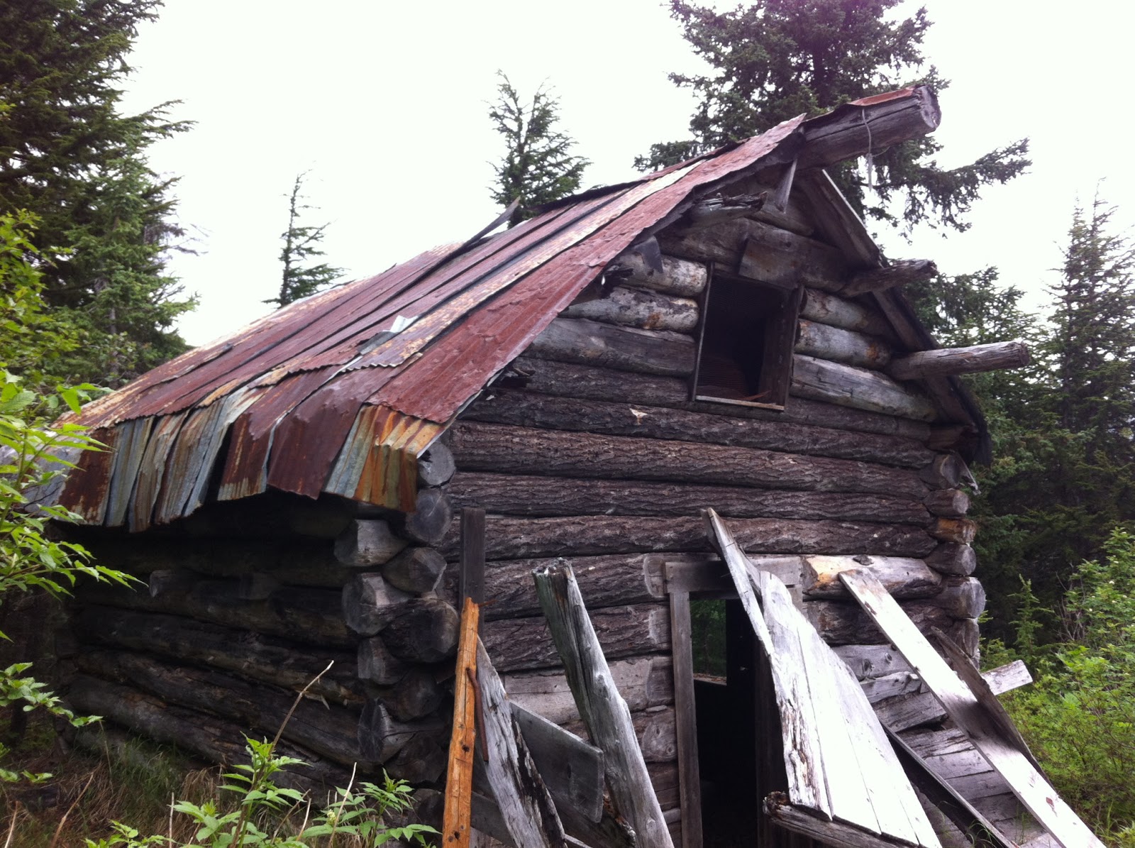
We've biked a little bit this summer, but not heavy duty backcountry trails.  Plus we'd just gotten off a month of fairly sedentary vacation, so we were not in shape.  Nor were we mentally prepared for the rough ride.  We just kept getting off our bikes and walking up or around the unbikeable sections.  We took frequent breaks, sometimes just standing by our bikes gasping, other times plopped down in the moss along the trail.  At one point we stopped and checked out an old cabin along the trail.  We skipped the trail turnoff to the waterfall, marked by a 3-rock cairn, not wanting to take a break quite that long.

An old cabin along the Primrose Trail.
We decided that our goal was to get above treeline.  Just minutes after we broke out of the trees, Aurora came running at us from the south, and then Douglas came over the rise, biking through the misting rain.  Aurora was in fine shape--not tired and very happy.  Douglas was tired.  Apparently nearly the entire trail from the beginning to the point where they met us was uphill besides a few small downhills (some that had to be walked down!).  I think he was too tired to chew me out for underestimating how far uphill it was.  Aurora was ahead of him the whole way, besides the times he made her push the bike!  It was a long 1800 foot climb for him, though it was smoother for him than it had been for us and he'd rarely had to get off.

The first patch of snow we come across in the summer is always cause for a snowball or two!
We all took a break and Denver and I had our lunch (read:  more substantial snack).  Then we turned around and headed back the way we'd come.  Aurora took off, her running pace being far faster than our biking pace even downhill.  In the first 10 minutes we were off our bikes quite a few times, walking down slick, muddy rocks, over patches of snow and dropoffs below tree roots.  Aurora patiently would wait up for us every so often.  We hardly had to pedal the whole way down it seemed (think--1800 feet in 5 1/2 miles), but we had to brake nearly constantly the whole way down too.

Even with controlling our speed it was a wild ride.  I fell off my pedals a number of times while standing on them going over the big roots (very grateful I am a female--hitting that middle bar is not comfortable either way!).  My 29" tires, which are great for going over things, are not as great at maneuvering around rocks and such, so it was a bit gnarly.  We all made it down in one piece, though as we found out later, our bikes did sustain some damage.  Our bike mechanic shook his head when he heard of our adventure and said, "That is one trail that is faster to run than bike!

So Douglas and Aurora did the whole thing in just over 4 hours including breaks, and Denver and I did about 11 miles (5 1/2 out, 5 1/2 back) in just under 4 hours.  It was....an adventure!  I don't have any inclination to do that again, but this blog entry will be my memory-jogger in case I ever do consider it!

I will say that when you're mountain biking a trail like this your complete attention is on the trail at all times so we had no time to look around and enjoy the scenery.  It was fast, intense and engaging, but we gave up some of the appreciation of the area by doing it that way.  I think that I would not want to do a trail like this only mountain biking.  I would want to hike it too in order to actually feel it and see it as opposed to just traverse its length.  And next time I hike a trail I'll notice the trail in terms of it's bikeability.  I totally did not notice those roots and rocks when I backpacked this trail just one year ago.  If I had, we might not have biked it!